Captain Jacks Stronghold Topo Map California
To zoom in, hover over the map of Captain Jacks Stronghold
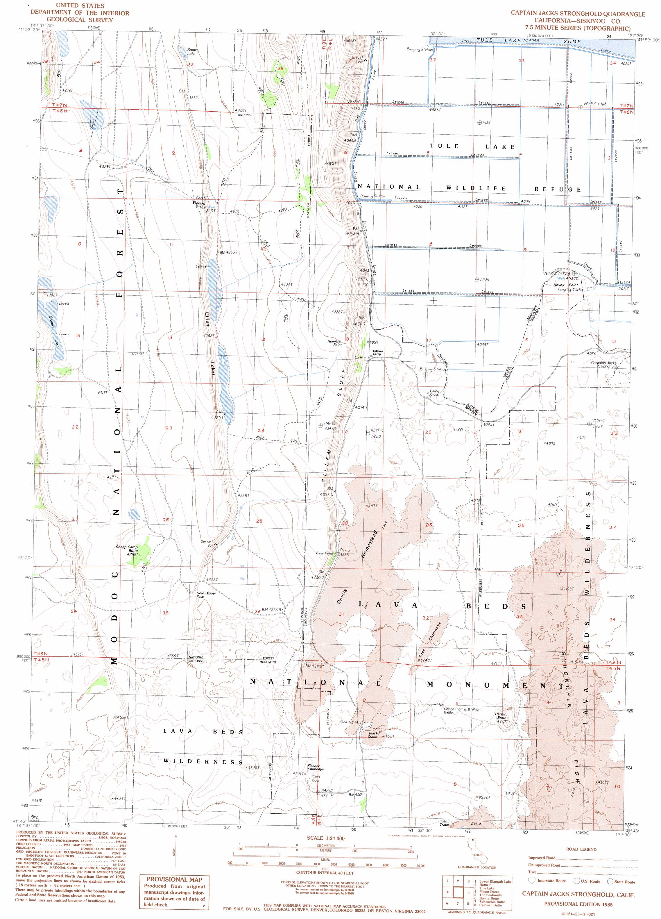
USGS Topo Quad 41121g5 - 1:24,000 scale
| Topo Map Name: | Captain Jacks Stronghold |
| USGS Topo Quad ID: | 41121g5 |
| Print Size: | ca. 21 1/4" wide x 27" high |
| Southeast Coordinates: | 41.75° N latitude / 121.5° W longitude |
| Map Center Coordinates: | 41.8125° N latitude / 121.5625° W longitude |
| U.S. State: | CA |
| Filename: | o41121g5.jpg |
| Download Map JPG Image: | Captain Jacks Stronghold topo map 1:24,000 scale |
| Map Type: | Topographic |
| Topo Series: | 7.5´ |
| Map Scale: | 1:24,000 |
| Source of Map Images: | United States Geological Survey (USGS) |
| Alternate Map Versions: |
Captain Jacks Stronghold CA 1985, updated 1985 Download PDF Buy paper map Captain Jacks Stronghold CA 1993, updated 1997 Download PDF Buy paper map Captain Jacks Stronghold CA 2012 Download PDF Buy paper map Captain Jacks Stronghold CA 2015 Download PDF Buy paper map |
| FStopo: | US Forest Service topo Captain Jacks Stronghold is available: Download FStopo PDF Download FStopo TIF |
1:24,000 Topo Quads surrounding Captain Jacks Stronghold
Worden |
Lost River |
Merrill |
Malin |
Bryant Mountain |
Sheepy Lake |
Lower Klamath Lake |
Hatfield |
Tulelake |
Newell |
Red Rock Lakes |
Mount Dome |
Captain Jacks Stronghold |
The Panhandle |
Copic |
Sharp Mountain |
Bonita Butte |
Schonchin Butte |
Caldwell Butte |
Perez |
Garner Mountain |
Little Glass Mountain |
Medicine Lake |
West Of Kephart |
Kephart |
> Back to 41121e1 at 1:100,000 scale
> Back to 41120a1 at 1:250,000 scale
> Back to U.S. Topo Maps home
Captain Jacks Stronghold topo map: Gazetteer
Captain Jacks Stronghold: Areas
Canby Bay elevation 1228m 4028′Captain Jacks Stronghold: Basins
Semig Basin elevation 1304m 4278′The Thumb of the Glove elevation 1320m 4330′
Captain Jacks Stronghold: Bays
Peninsula Bay elevation 1227m 4025′Captain Jacks Stronghold: Capes
Hovey Point elevation 1237m 4058′Captain Jacks Stronghold: Cliffs
Gillem Bluff elevation 1334m 4376′Howitzer Point elevation 1346m 4416′
Captain Jacks Stronghold: Craters
Black Crater elevation 1340m 4396′Captain Jacks Stronghold: Gaps
Gold Digge Pass elevation 1318m 4324′Captain Jacks Stronghold: Lakes
Boozey Lake elevation 1333m 4373′Crumes Lake elevation 1290m 4232′
Gillem Lakes elevation 1287m 4222′
Captain Jacks Stronghold: Lavas
Devils Homestead elevation 1268m 4160′Ross Flow elevation 1285m 4215′
Schonchin Flow elevation 1336m 4383′
Captain Jacks Stronghold: Parks
Lava Beds National Monument elevation 1340m 4396′Tule Lake National Wildlife Refuge elevation 1230m 4035′
Captain Jacks Stronghold: Pillars
Fleener Chimneys elevation 1363m 4471′Ross Chimneys elevation 1288m 4225′
Captain Jacks Stronghold: Populated Places
Canby Cross elevation 1237m 4058′Fleener Place elevation 1307m 4288′
Captain Jacks Stronghold: Ridges
Roemer Ridge elevation 1286m 4219′Wright Ridge elevation 1330m 4363′
Captain Jacks Stronghold: Summits
Cranston Knob elevation 1313m 4307′Hardin Butte elevation 1351m 4432′
Harris Knoll elevation 1324m 4343′
Howe Point elevation 1323m 4340′
Sheep Camp Butte elevation 1333m 4373′
Thomas Hill elevation 1325m 4347′
Captain Jacks Stronghold: Trails
Gillem Bluff Trail elevation 1242m 4074′Captain Jacks Stronghold: Valleys
Clinton Draw elevation 1288m 4225′Captain Jacks Stronghold digital topo map on disk
Buy this Captain Jacks Stronghold topo map showing relief, roads, GPS coordinates and other geographical features, as a high-resolution digital map file on DVD: