Shoeinhorse Mountain Topo Map California
To zoom in, hover over the map of Shoeinhorse Mountain
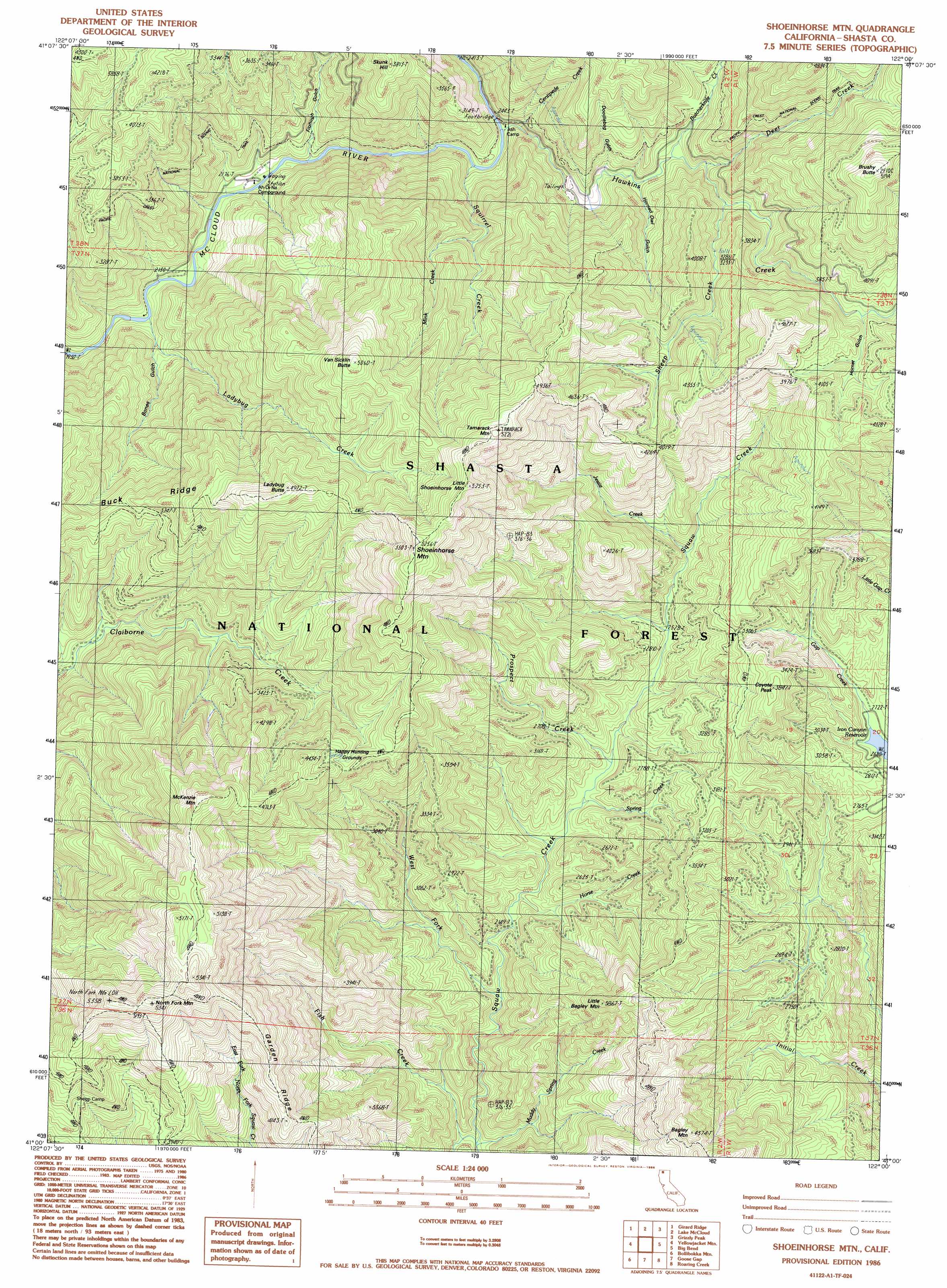
USGS Topo Quad 41122a1 - 1:24,000 scale
| Topo Map Name: | Shoeinhorse Mountain |
| USGS Topo Quad ID: | 41122a1 |
| Print Size: | ca. 21 1/4" wide x 27" high |
| Southeast Coordinates: | 41° N latitude / 122° W longitude |
| Map Center Coordinates: | 41.0625° N latitude / 122.0625° W longitude |
| U.S. State: | CA |
| Filename: | o41122a1.jpg |
| Download Map JPG Image: | Shoeinhorse Mountain topo map 1:24,000 scale |
| Map Type: | Topographic |
| Topo Series: | 7.5´ |
| Map Scale: | 1:24,000 |
| Source of Map Images: | United States Geological Survey (USGS) |
| Alternate Map Versions: |
Shoeinhorse Mountain CA 1986, updated 1986 Download PDF Buy paper map Shoeinhorse Mountain CA 1998, updated 2003 Download PDF Buy paper map Shoeinhorse Mountain CA 2012 Download PDF Buy paper map Shoeinhorse Mountain CA 2015 Download PDF Buy paper map |
| FStopo: | US Forest Service topo Shoeinhorse Mountain is available: Download FStopo PDF Download FStopo TIF |
1:24,000 Topo Quads surrounding Shoeinhorse Mountain
City Of Mount Shasta |
Mccloud |
Elk Spring |
Kinyon |
Bartle |
Dunsmuir |
Girard Ridge |
Lake Mccloud |
Grizzly Peak |
Dead Horse Summit |
Tombstone Mountain |
Yellowjacket Mountain |
Shoeinhorse Mountain |
Big Bend |
Skunk Ridge |
Hanland Peak |
Bollibokka Mountain |
Goose Gap |
Roaring Creek |
Chalk Mountain |
O'Brien |
Minnesota Mountain |
Devils Rock |
Montgomery Creek |
Hatchet Mountain Pass |
> Back to 41122a1 at 1:100,000 scale
> Back to 41122a1 at 1:250,000 scale
> Back to U.S. Topo Maps home
Shoeinhorse Mountain topo map: Gazetteer
Shoeinhorse Mountain: Ridges
Buck Ridge elevation 1100m 3608′Garden Ridge elevation 1317m 4320′
Shoeinhorse Mountain: Streams
Butcherknife Creek elevation 867m 2844′Centipede Creek elevation 761m 2496′
Deer Creek elevation 890m 2919′
Fish Creek elevation 580m 1902′
Gap Creek elevation 826m 2709′
Hawkins Creek elevation 723m 2372′
Horse Creek elevation 658m 2158′
Jessie Creek elevation 843m 2765′
Ladybug Creek elevation 613m 2011′
Mink Creek elevation 938m 3077′
Muddy Spring Creek elevation 600m 1968′
Prospect Creek elevation 725m 2378′
Sheep Creek elevation 953m 3126′
Spring Creek elevation 712m 2335′
Squirrel Creek elevation 714m 2342′
West Fork Squaw Creek elevation 648m 2125′
Shoeinhorse Mountain: Summits
Brushy Butte elevation 1579m 5180′Coyote Peak elevation 953m 3126′
Ladybug Butte elevation 1503m 4931′
Little Bagley Mountain elevation 1158m 3799′
Little Shoeinhorse Mountain elevation 1421m 4662′
McKenzie Mountain elevation 1541m 5055′
North Fork Mountain elevation 1609m 5278′
Shoeinhorse Mountain elevation 1568m 5144′
Tamarack Mountain elevation 1583m 5193′
Van Sicklin Butte elevation 1533m 5029′
Shoeinhorse Mountain: Trails
Curl Ridge Jeep Trail elevation 1517m 4977′Shoeinhorse Mountain: Valleys
Bones Gulch elevation 644m 2112′Doodlebug Gulch elevation 840m 2755′
Fitzhugh Gulch elevation 706m 2316′
Horned Owl Gulch elevation 841m 2759′
Hornet Gulch elevation 1107m 3631′
Shoeinhorse Mountain digital topo map on disk
Buy this Shoeinhorse Mountain topo map showing relief, roads, GPS coordinates and other geographical features, as a high-resolution digital map file on DVD: