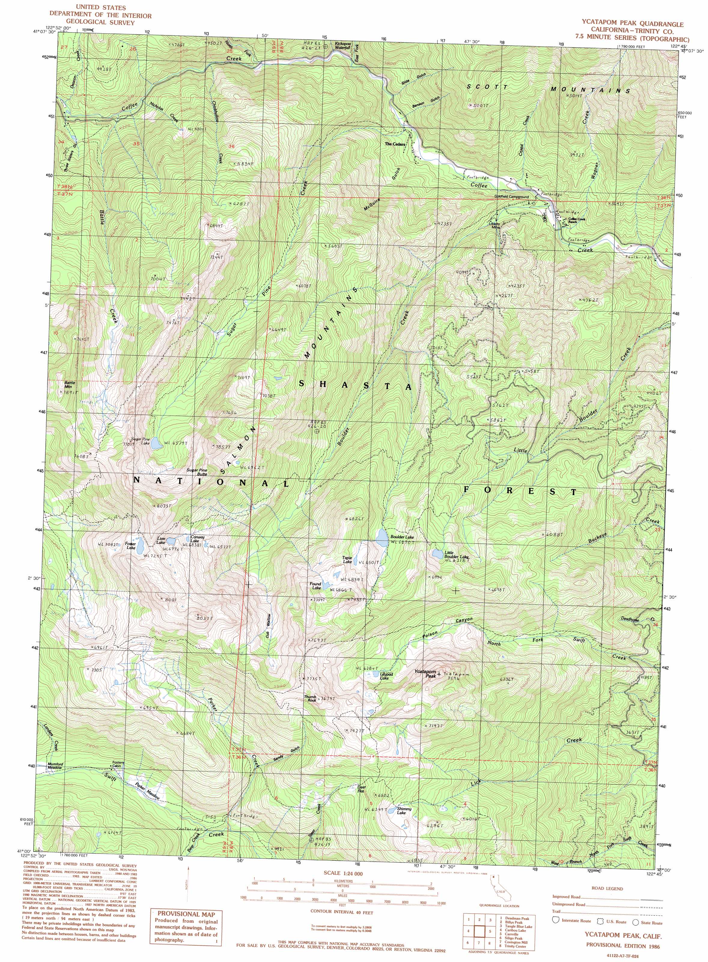
Ycatapom Peak Topo Map California
To zoom in, hover over the map of Ycatapom Peak
USGS Topo Quad 41122a7 - 1:24,000 scale
| Topo Map Name: | Ycatapom Peak |
| USGS Topo Quad ID: | 41122a7 |
| Print Size: | ca. 21 1/4" wide x 27" high |
| Southeast Coordinates: | 41° N latitude / 122.75° W longitude |
| Map Center Coordinates: | 41.0625° N latitude / 122.8125° W longitude |
| U.S. State: | CA |
| Filename: | o41122a7.jpg |
| Download Map JPG Image: | Ycatapom Peak topo map 1:24,000 scale |
| Map Type: | Topographic |
| Topo Series: | 7.5´ |
| Map Scale: | 1:24,000 |
| Source of Map Images: | United States Geological Survey (USGS) |
| Alternate Map Versions: |
Ycatapom Peak CA 1986, updated 1986 Download PDF Buy paper map Ycatapom Peak CA 1998, updated 2003 Download PDF Buy paper map Ycatapom Peak CA 1998, updated 2003 Download PDF Buy paper map Ycatapom Peak CA 2012 Download PDF Buy paper map Ycatapom Peak CA 2015 Download PDF Buy paper map |
| FStopo: | US Forest Service topo Ycatapom Peak is available: Download FStopo PDF Download FStopo TIF |
1:24,000 Topo Quads surrounding Ycatapom Peak
Tanners Peak |
Eaton Peak |
Callahan |
Scott Mountain |
South China Mountain |
Grasshopper Ridge |
Deadman Peak |
Billys Peak |
Tangle Blue Lake |
Mumbo Basin |
Thompson Peak |
Caribou Lake |
Ycatapom Peak |
Carrville |
Whisky Bill Peak |
Mount Hilton |
Siligo Peak |
Covington Mill |
Trinity Center |
Damnation Peak |
Dedrick |
Rush Creek Lakes |
Trinity Dam |
Papoose Creek |
Schell Mountain |
> Back to 41122a1 at 1:100,000 scale
> Back to 41122a1 at 1:250,000 scale
> Back to U.S. Topo Maps home
Ycatapom Peak topo map: Gazetteer
Ycatapom Peak: Basins
Cub Wallow elevation 1955m 6414′Ycatapom Peak: Falls
Kickapoo Waterfall elevation 1039m 3408′Ycatapom Peak: Flats
Deer Flat elevation 1952m 6404′Mumford Meadow elevation 1685m 5528′
Parker Meadow elevation 1619m 5311′
Ycatapom Peak: Lakes
Boulder Lake elevation 1857m 6092′Conway Lake elevation 2076m 6811′
Foster Lake elevation 2218m 7276′
Found Lake elevation 2094m 6870′
Lilypad Lake elevation 1922m 6305′
Lion Lake elevation 2158m 7080′
Little Boulder Lake elevation 1927m 6322′
Shimmy Lake elevation 1938m 6358′
Sugar Pine Lake elevation 2006m 6581′
Tapie Lake elevation 1988m 6522′
Union Lakes elevation 1974m 6476′
Ycatapom Peak: Mines
Lady Slipper Mine elevation 1391m 4563′Lady Slipper Mine elevation 1436m 4711′
Liberty Mine elevation 964m 3162′
Ycatapom Peak: Populated Places
Coffee elevation 912m 2992′Ycatapom Peak: Streams
Battle Creek elevation 1219m 3999′Bear Creek elevation 1554m 5098′
Boulder Creek elevation 891m 2923′
Chinkhollow Creek elevation 1116m 3661′
Crystal Creek elevation 913m 2995′
Deacon Creek elevation 1291m 4235′
East Fork Coffee Creek elevation 1007m 3303′
Landers Creek elevation 1667m 5469′
Nicholas Creek elevation 1216m 3989′
North Fork Coffee Creek elevation 1088m 3569′
Parker Creek elevation 1534m 5032′
Sugar Pine Creek elevation 969m 3179′
Wagner Creek elevation 884m 2900′
Ycatapom Peak: Summits
Battle Mountain elevation 2322m 7618′Sugar Pine Butte elevation 2335m 7660′
Ycatapom Peak elevation 2296m 7532′
Ycatapom Peak: Valleys
Benson Gulch elevation 980m 3215′McGuire Gulch elevation 949m 3113′
Poison Canyon elevation 1311m 4301′
Sandy Canyon elevation 1787m 5862′
Sandy Gulch elevation 1709m 5606′
Slide Gulch elevation 1057m 3467′
Three Sisters Gulch elevation 1266m 4153′
Ycatapom Peak digital topo map on disk
Buy this Ycatapom Peak topo map showing relief, roads, GPS coordinates and other geographical features, as a high-resolution digital map file on DVD: