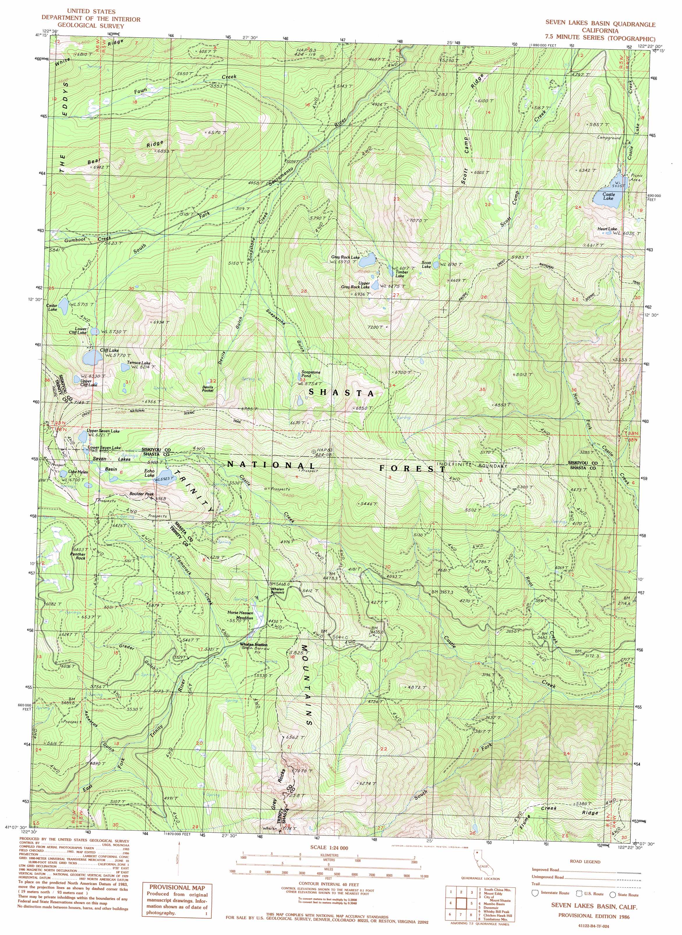
Seven Lakes Basin Topo Map California
To zoom in, hover over the map of Seven Lakes Basin
USGS Topo Quad 41122b4 - 1:24,000 scale
| Topo Map Name: | Seven Lakes Basin |
| USGS Topo Quad ID: | 41122b4 |
| Print Size: | ca. 21 1/4" wide x 27" high |
| Southeast Coordinates: | 41.125° N latitude / 122.375° W longitude |
| Map Center Coordinates: | 41.1875° N latitude / 122.4375° W longitude |
| U.S. State: | CA |
| Filename: | o41122b4.jpg |
| Download Map JPG Image: | Seven Lakes Basin topo map 1:24,000 scale |
| Map Type: | Topographic |
| Topo Series: | 7.5´ |
| Map Scale: | 1:24,000 |
| Source of Map Images: | United States Geological Survey (USGS) |
| Alternate Map Versions: |
Seven Lakes Basin CA 1986, updated 1986 Download PDF Buy paper map Seven Lakes Basin CA 1986, updated 1986 Download PDF Buy paper map Seven Lakes Basin CA 1998, updated 2003 Download PDF Buy paper map Seven Lakes Basin CA 2012 Download PDF Buy paper map Seven Lakes Basin CA 2015 Download PDF Buy paper map |
| FStopo: | US Forest Service topo Seven Lakes Basin is available: Download FStopo PDF Download FStopo TIF |
1:24,000 Topo Quads surrounding Seven Lakes Basin
Gazelle Mountain |
China Mountain |
Weed |
Hotlum |
Mount Shasta |
Scott Mountain |
South China Mountain |
Mount Eddy |
City Of Mount Shasta |
Mccloud |
Tangle Blue Lake |
Mumbo Basin |
Seven Lakes Basin |
Dunsmuir |
Girard Ridge |
Carrville |
Whisky Bill Peak |
Chicken Hawk Hill |
Tombstone Mountain |
Yellowjacket Mountain |
Trinity Center |
Damnation Peak |
Lamoine |
Hanland Peak |
Bollibokka Mountain |
> Back to 41122a1 at 1:100,000 scale
> Back to 41122a1 at 1:250,000 scale
> Back to U.S. Topo Maps home
Seven Lakes Basin topo map: Gazetteer
Seven Lakes Basin: Basins
Devils Pocket elevation 1904m 6246′Seven Lakes elevation 1891m 6204′
Seven Lakes Basin: Flats
Horse Heaven Meadows elevation 1655m 5429′Seven Lakes Basin: Gaps
Whalan Summit elevation 1686m 5531′Seven Lakes Basin: Lakes
Castle Lake elevation 1658m 5439′Cedar Lake elevation 1743m 5718′
Cliff Lake elevation 1760m 5774′
Echo Lake elevation 1806m 5925′
Gray Rock Lake elevation 1821m 5974′
Heart Lake elevation 1852m 6076′
Lake Helen elevation 2046m 6712′
Lower Cliff Lake elevation 1752m 5748′
Lower Seven Lake elevation 1888m 6194′
Scott Lake elevation 1887m 6190′
Soapstone Lake (historical) elevation 1873m 6145′
Soapstone Pond elevation 1755m 5757′
Terrace Lake elevation 1899m 6230′
Timber Lake elevation 1838m 6030′
Upper Cliff Lake elevation 1934m 6345′
Upper Gray Rock Lake elevation 1913m 6276′
Upper Seven Lake elevation 1897m 6223′
Seven Lakes Basin: Mines
Ruby Pearl Mine elevation 1627m 5337′Seven Lakes Basin: Pillars
Panther Rock elevation 2002m 6568′Seven Lakes Basin: Ridges
Bear Ridge elevation 2101m 6893′Scott Camp Ridge elevation 1748m 5734′
Seven Lakes Basin: Streams
Fawn Creek elevation 1445m 4740′Root Creek elevation 769m 2522′
Soapstone Creek elevation 1505m 4937′
South Fork Castle Creek elevation 831m 2726′
Tamarack Creek elevation 1627m 5337′
Seven Lakes Basin: Summits
Boulder Peak elevation 2086m 6843′Grey Rocks elevation 2190m 7185′
Seven Lakes Basin: Trails
Echo Lake Trail elevation 1749m 5738′Seven Lakes Basin: Valleys
Asbestos Gulch elevation 1430m 4691′Devils Gulch elevation 1604m 5262′
Grader Gulch elevation 1589m 5213′
Soapstone Gulch elevation 1589m 5213′
Seven Lakes Basin digital topo map on disk
Buy this Seven Lakes Basin topo map showing relief, roads, GPS coordinates and other geographical features, as a high-resolution digital map file on DVD: