City Of Mount Shasta Topo Map California
To zoom in, hover over the map of City Of Mount Shasta
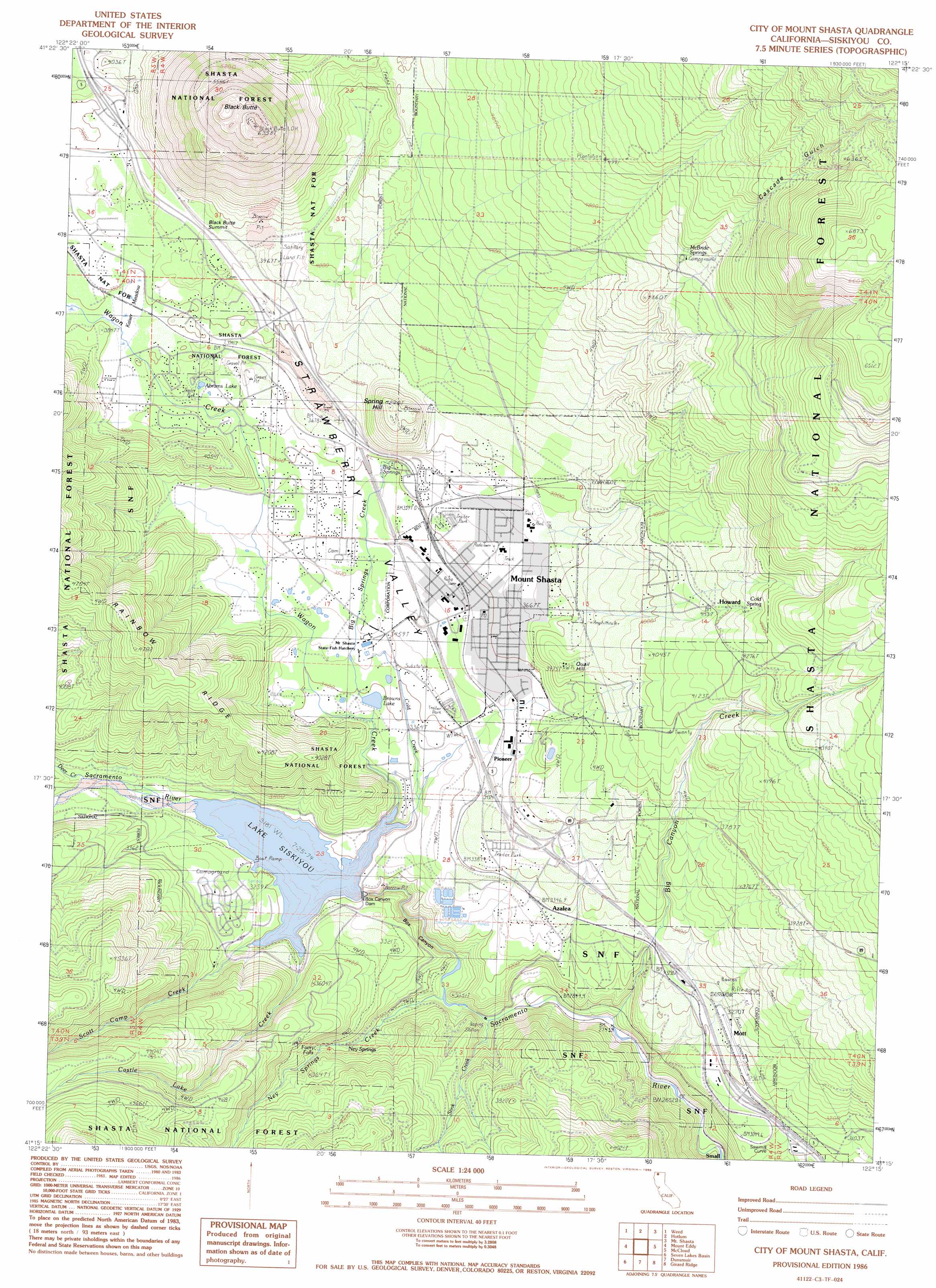
USGS Topo Quad 41122c3 - 1:24,000 scale
| Topo Map Name: | City Of Mount Shasta |
| USGS Topo Quad ID: | 41122c3 |
| Print Size: | ca. 21 1/4" wide x 27" high |
| Southeast Coordinates: | 41.25° N latitude / 122.25° W longitude |
| Map Center Coordinates: | 41.3125° N latitude / 122.3125° W longitude |
| U.S. State: | CA |
| Filename: | o41122c3.jpg |
| Download Map JPG Image: | City Of Mount Shasta topo map 1:24,000 scale |
| Map Type: | Topographic |
| Topo Series: | 7.5´ |
| Map Scale: | 1:24,000 |
| Source of Map Images: | United States Geological Survey (USGS) |
| Alternate Map Versions: |
City of Mount Shasta CA 1986, updated 1986 Download PDF Buy paper map City of Mount Shasta CA 1998, updated 2003 Download PDF Buy paper map City of Mount Shasta CA 2012 Download PDF Buy paper map City of Mount Shasta CA 2015 Download PDF Buy paper map |
| FStopo: | US Forest Service topo City of Mount Shasta is available: Download FStopo PDF Download FStopo TIF |
1:24,000 Topo Quads surrounding City Of Mount Shasta
Gazelle |
Lake Shastina |
Juniper Flat |
The Whaleback |
West Haight Mountain |
China Mountain |
Weed |
Hotlum |
Mount Shasta |
Ash Creek Butte |
South China Mountain |
Mount Eddy |
City Of Mount Shasta |
Mccloud |
Elk Spring |
Mumbo Basin |
Seven Lakes Basin |
Dunsmuir |
Girard Ridge |
Lake Mccloud |
Whisky Bill Peak |
Chicken Hawk Hill |
Tombstone Mountain |
Yellowjacket Mountain |
Shoeinhorse Mountain |
> Back to 41122a1 at 1:100,000 scale
> Back to 41122a1 at 1:250,000 scale
> Back to U.S. Topo Maps home
City Of Mount Shasta topo map: Gazetteer
City Of Mount Shasta: Airports
Dunsmuir Municipal Airport elevation 992m 3254′City Of Mount Shasta: Bends
Sawmill Curve elevation 930m 3051′City Of Mount Shasta: Dams
Box Canyon Dam elevation 933m 3061′City Of Mount Shasta: Falls
Faery Falls elevation 999m 3277′City Of Mount Shasta: Flats
Kaiser Meadow elevation 1155m 3789′City Of Mount Shasta: Gaps
Black Butte Summit elevation 1199m 3933′City Of Mount Shasta: Lakes
Abrams Lake elevation 1131m 3710′Browns Lake elevation 1032m 3385′
Siskiyou Lake elevation 971m 3185′
City Of Mount Shasta: Parks
Mount Shasta City Park elevation 1096m 3595′Shastise Park elevation 1140m 3740′
City Of Mount Shasta: Populated Places
Abrams Lake Mobile Estates elevation 1134m 3720′Azalea elevation 1021m 3349′
Cantara (historical) elevation 839m 2752′
Chateau Shasta Mobile Home Park elevation 1050m 3444′
Howard elevation 1269m 4163′
Mott elevation 971m 3185′
Mount Shasta elevation 1099m 3605′
Pioneer elevation 1062m 3484′
Shadow Mountain Mobile Home Park elevation 1008m 3307′
Upton elevation 1141m 3743′
City Of Mount Shasta: Post Offices
Mount Shasta Post Office elevation 1093m 3585′City Of Mount Shasta: Reservoirs
Lake Siskiyou elevation 975m 3198′City Of Mount Shasta: Ridges
Rainbow Ridge elevation 1447m 4747′City Of Mount Shasta: Springs
Big Springs elevation 1095m 3592′Cold Spring elevation 1325m 4347′
McBride Springs elevation 1506m 4940′
Ney Springs elevation 971m 3185′
City Of Mount Shasta: Streams
Big Canyon Creek elevation 831m 2726′Big Springs Creek elevation 1042m 3418′
Castle Lake Creek elevation 971m 3185′
Cold Creek elevation 979m 3211′
Deer Creek elevation 1001m 3284′
Ney Springs Creek elevation 865m 2837′
Scott Camp Creek elevation 971m 3185′
Stink Creek elevation 884m 2900′
Wagon Creek elevation 971m 3185′
City Of Mount Shasta: Summits
Black Butte elevation 1903m 6243′Quail Hill elevation 1210m 3969′
Spring Hill elevation 1294m 4245′
City Of Mount Shasta: Valleys
Box Canyon elevation 871m 2857′Cascade Gulch elevation 1312m 4304′
City Of Mount Shasta digital topo map on disk
Buy this City Of Mount Shasta topo map showing relief, roads, GPS coordinates and other geographical features, as a high-resolution digital map file on DVD: