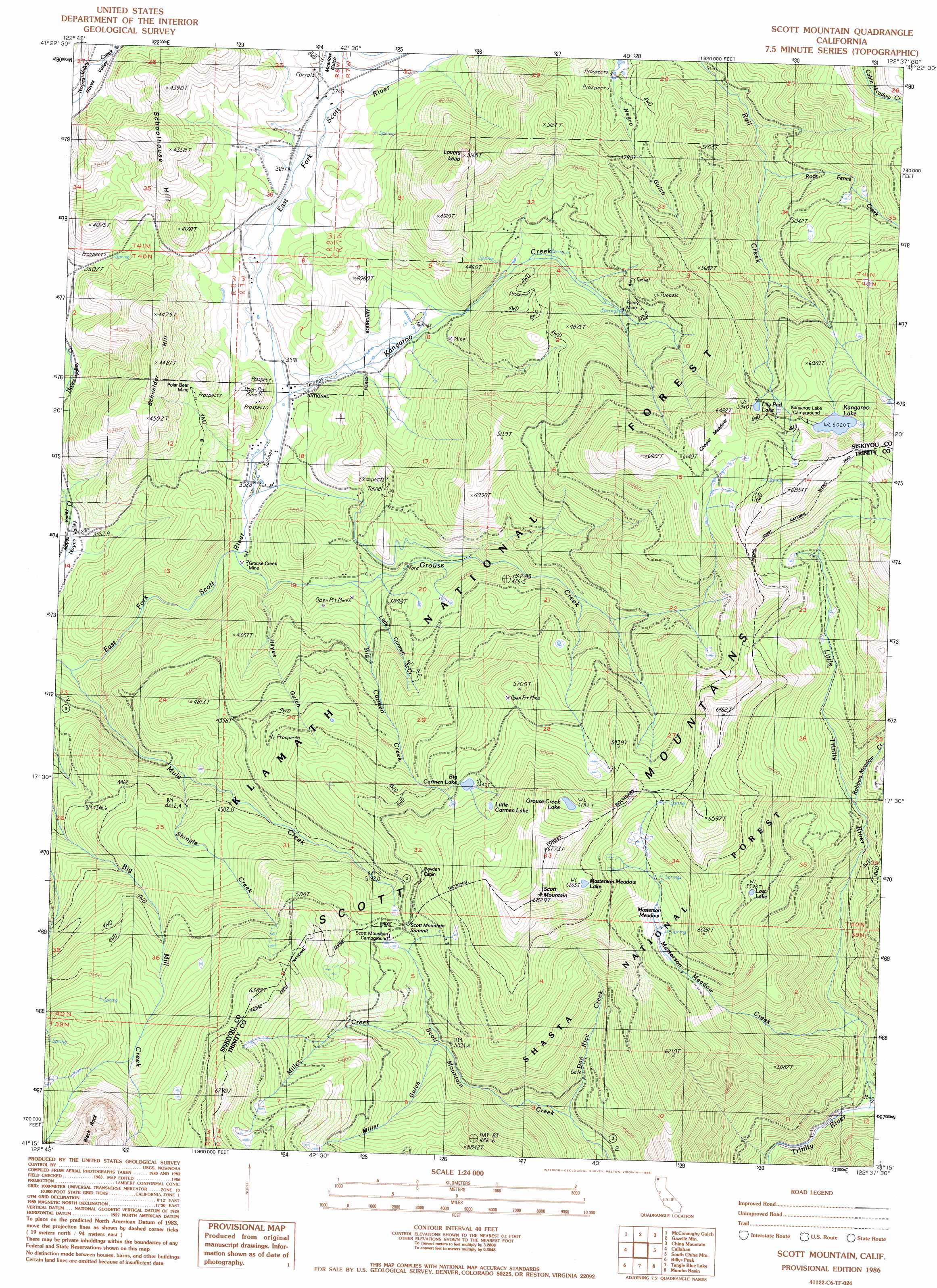
Scott Mountain Topo Map California
To zoom in, hover over the map of Scott Mountain
USGS Topo Quad 41122c6 - 1:24,000 scale
| Topo Map Name: | Scott Mountain |
| USGS Topo Quad ID: | 41122c6 |
| Print Size: | ca. 21 1/4" wide x 27" high |
| Southeast Coordinates: | 41.25° N latitude / 122.625° W longitude |
| Map Center Coordinates: | 41.3125° N latitude / 122.6875° W longitude |
| U.S. State: | CA |
| Filename: | o41122c6.jpg |
| Download Map JPG Image: | Scott Mountain topo map 1:24,000 scale |
| Map Type: | Topographic |
| Topo Series: | 7.5´ |
| Map Scale: | 1:24,000 |
| Source of Map Images: | United States Geological Survey (USGS) |
| Alternate Map Versions: |
Scott Mountain CA 1986, updated 1986 Download PDF Buy paper map Scott Mountain CA 2001, updated 2004 Download PDF Buy paper map Scott Mountain CA 2012 Download PDF Buy paper map Scott Mountain CA 2015 Download PDF Buy paper map |
| FStopo: | US Forest Service topo Scott Mountain is available: Download FStopo PDF Download FStopo TIF |
1:24,000 Topo Quads surrounding Scott Mountain
Greenview |
Fort Jones |
Duzel Rock |
Gazelle |
Lake Shastina |
Etna |
Mcconaughy Gulch |
Gazelle Mountain |
China Mountain |
Weed |
Eaton Peak |
Callahan |
Scott Mountain |
South China Mountain |
Mount Eddy |
Deadman Peak |
Billys Peak |
Tangle Blue Lake |
Mumbo Basin |
Seven Lakes Basin |
Caribou Lake |
Ycatapom Peak |
Carrville |
Whisky Bill Peak |
Chicken Hawk Hill |
> Back to 41122a1 at 1:100,000 scale
> Back to 41122a1 at 1:250,000 scale
> Back to U.S. Topo Maps home
Scott Mountain topo map: Gazetteer
Scott Mountain: Dams
Kangaroo Lake Dam elevation 1836m 6023′Scott Mountain: Flats
Cooper Meadow elevation 1917m 6289′Masterson Meadow elevation 1661m 5449′
Scott Mountain: Gaps
Scott Mountain Summit elevation 1695m 5561′Scott Mountain: Lakes
Big Carmen Lake elevation 1691m 5547′Grouse Creek Lake elevation 1888m 6194′
Lily Pad Lake elevation 1817m 5961′
Little Carmen Lake elevation 1767m 5797′
Lost Lake elevation 1707m 5600′
Masterson Meadow Lake elevation 1899m 6230′
Scott Mountain: Mines
Chapman Mine elevation 1500m 4921′Facey Mine elevation 1387m 4550′
Grouse Creek Mine elevation 1068m 3503′
Polar Bear Mine elevation 1186m 3891′
Scott Mountain: Ranges
Scott Mountains elevation 1947m 6387′Scott Mountain: Reservoirs
Kangaroo Lake elevation 1836m 6023′Scott Mountain: Streams
Big Carmen Creek elevation 1129m 3704′Dan Rice Creek elevation 1336m 4383′
Grouse Creek elevation 1062m 3484′
Kangaroo Creek elevation 1090m 3576′
Little Carmen Creek elevation 1156m 3792′
Little Trinity River elevation 1083m 3553′
Masterson Meadow Creek elevation 1164m 3818′
Miller Creek elevation 1533m 5029′
Mule Creek elevation 1017m 3336′
Robbers Meadow Creek elevation 1462m 4796′
Rock Fence Creek elevation 1374m 4507′
Shingle Creek elevation 1262m 4140′
Scott Mountain: Summits
Lovers Leap elevation 1548m 5078′Schneider Hill elevation 1344m 4409′
Schoolhouse Hill elevation 1304m 4278′
Scott Mountain elevation 2049m 6722′
Scott Mountain: Valleys
Hayes Gulch elevation 1093m 3585′Miller Gulch elevation 1543m 5062′
Scott Mountain digital topo map on disk
Buy this Scott Mountain topo map showing relief, roads, GPS coordinates and other geographical features, as a high-resolution digital map file on DVD: