Condrey Mountain Topo Map California
To zoom in, hover over the map of Condrey Mountain
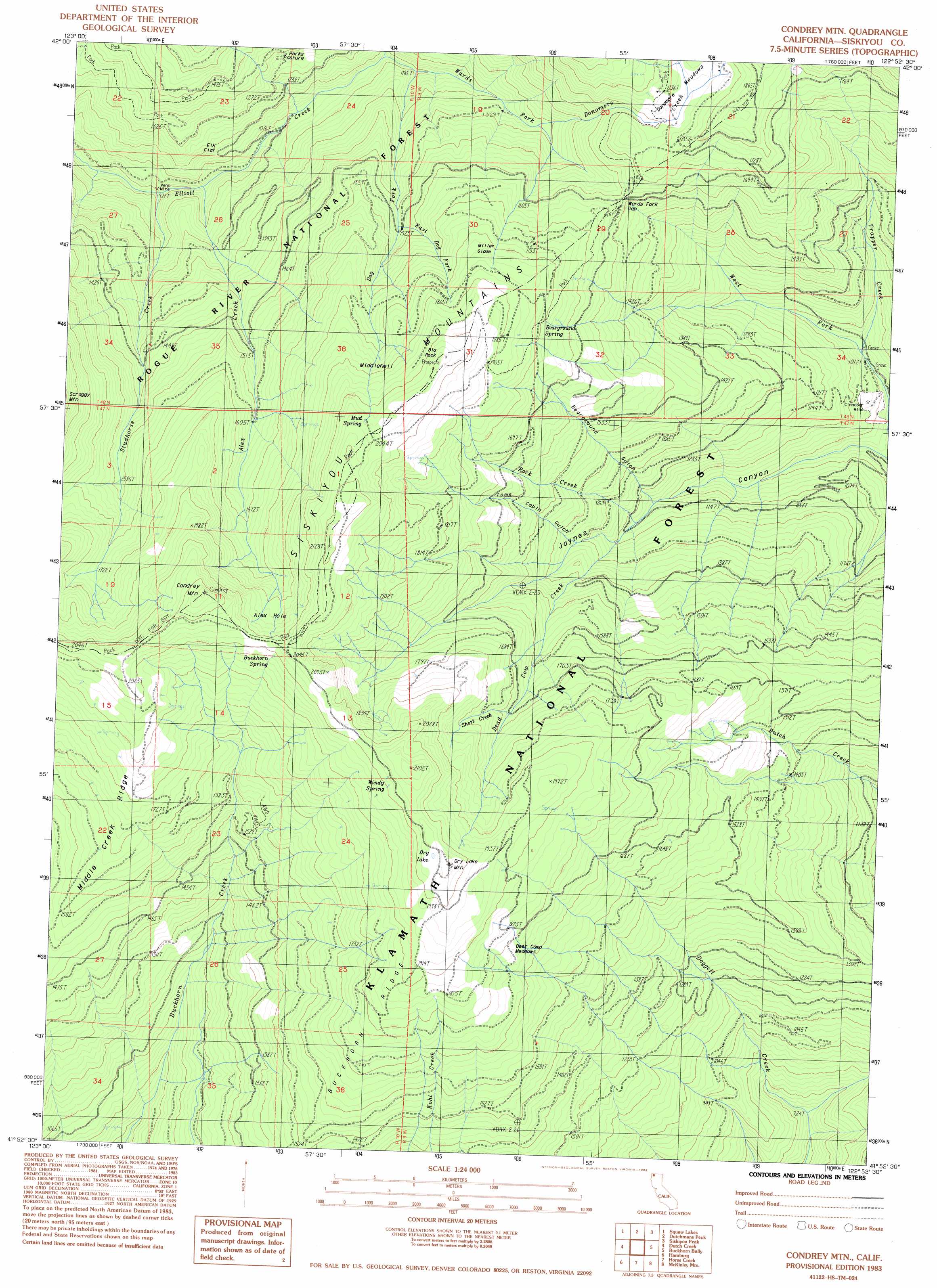
USGS Topo Quad 41122h8 - 1:24,000 scale
| Topo Map Name: | Condrey Mountain |
| USGS Topo Quad ID: | 41122h8 |
| Print Size: | ca. 21 1/4" wide x 27" high |
| Southeast Coordinates: | 41.875° N latitude / 122.875° W longitude |
| Map Center Coordinates: | 41.9375° N latitude / 122.9375° W longitude |
| U.S. State: | CA |
| Filename: | o41122h8.jpg |
| Download Map JPG Image: | Condrey Mountain topo map 1:24,000 scale |
| Map Type: | Topographic |
| Topo Series: | 7.5´ |
| Map Scale: | 1:24,000 |
| Source of Map Images: | United States Geological Survey (USGS) |
| Alternate Map Versions: |
Condrey Mtn CA 1983, updated 1984 Download PDF Buy paper map Condrey Mountain CA 1998, updated 2001 Download PDF Buy paper map Condrey Mountain CA 2012 Download PDF Buy paper map Condrey Mountain CA 2015 Download PDF Buy paper map |
| FStopo: | US Forest Service topo Condrey Mountain is available: Download FStopo PDF Download FStopo TIF |
1:24,000 Topo Quads surrounding Condrey Mountain
Tallowbox Mountain |
Ruch |
Sterling Creek |
Talent |
Ashland |
Carberry Creek |
Squaw Lakes |
Dutchman Peak |
Siskiyou Peak |
Mount Ashland |
Kangaroo Mountain |
Dutch Creek |
Condrey Mountain |
Buckhorn Bally |
Cottonwood Peak |
Seiad Valley |
Hamburg |
Horse Creek |
Mckinley Mountain |
Badger Mountain |
Grider Valley |
Scott Bar |
Russell Peak |
Indian Creek Baldy |
Yreka |
> Back to 41122e1 at 1:100,000 scale
> Back to 41122a1 at 1:250,000 scale
> Back to U.S. Topo Maps home
Condrey Mountain topo map: Gazetteer
Condrey Mountain: Areas
Middlehell elevation 1846m 6056′Condrey Mountain: Basins
Dry Lake elevation 2036m 6679′Condrey Mountain: Bends
Alex Hole elevation 1877m 6158′Condrey Mountain: Capes
Trapper Point elevation 1807m 5928′Condrey Mountain: Flats
Deer Camp Meadows elevation 1801m 5908′Donomore Meadows elevation 1742m 5715′
Elk Flat elevation 1189m 3900′
Miller Glade elevation 1833m 6013′
Perks Pasture elevation 1339m 4393′
Condrey Mountain: Gaps
Wards Fork Gap elevation 1598m 5242′Condrey Mountain: Mines
Cinnabar Mine elevation 1092m 3582′Penn Mine elevation 981m 3218′
Condrey Mountain: Pillars
Big Rock elevation 2033m 6669′Condrey Mountain: Springs
Bearground Spring elevation 1855m 6085′Buckhorn Spring elevation 1985m 6512′
Cinnabar Springs elevation 1033m 3389′
Mud Spring elevation 2037m 6683′
Windy Spring elevation 2000m 6561′
Condrey Mountain: Streams
Alex Creek elevation 1037m 3402′Buckeye Creek elevation 1585m 5200′
Dead Cow Creek elevation 1273m 4176′
Dog Fork elevation 1192m 3910′
Donomore Creek elevation 1370m 4494′
East Dog Fork elevation 1532m 5026′
Rock Creek elevation 1231m 4038′
Short Creek elevation 1688m 5538′
Silver Fork elevation 1171m 3841′
Studhorse Creek elevation 985m 3231′
Trapper Creek elevation 1100m 3608′
Wards Fork elevation 1171m 3841′
Condrey Mountain: Summits
Condrey Mountain elevation 2164m 7099′Dry Lake Mountain elevation 2063m 6768′
Condrey Mountain: Valleys
Bearground Gulch elevation 1220m 4002′Jaynes Canyon elevation 954m 3129′
Toms Cabin Gulch elevation 1359m 4458′
Condrey Mountain digital topo map on disk
Buy this Condrey Mountain topo map showing relief, roads, GPS coordinates and other geographical features, as a high-resolution digital map file on DVD: