Tish Tang Point Topo Map California
To zoom in, hover over the map of Tish Tang Point
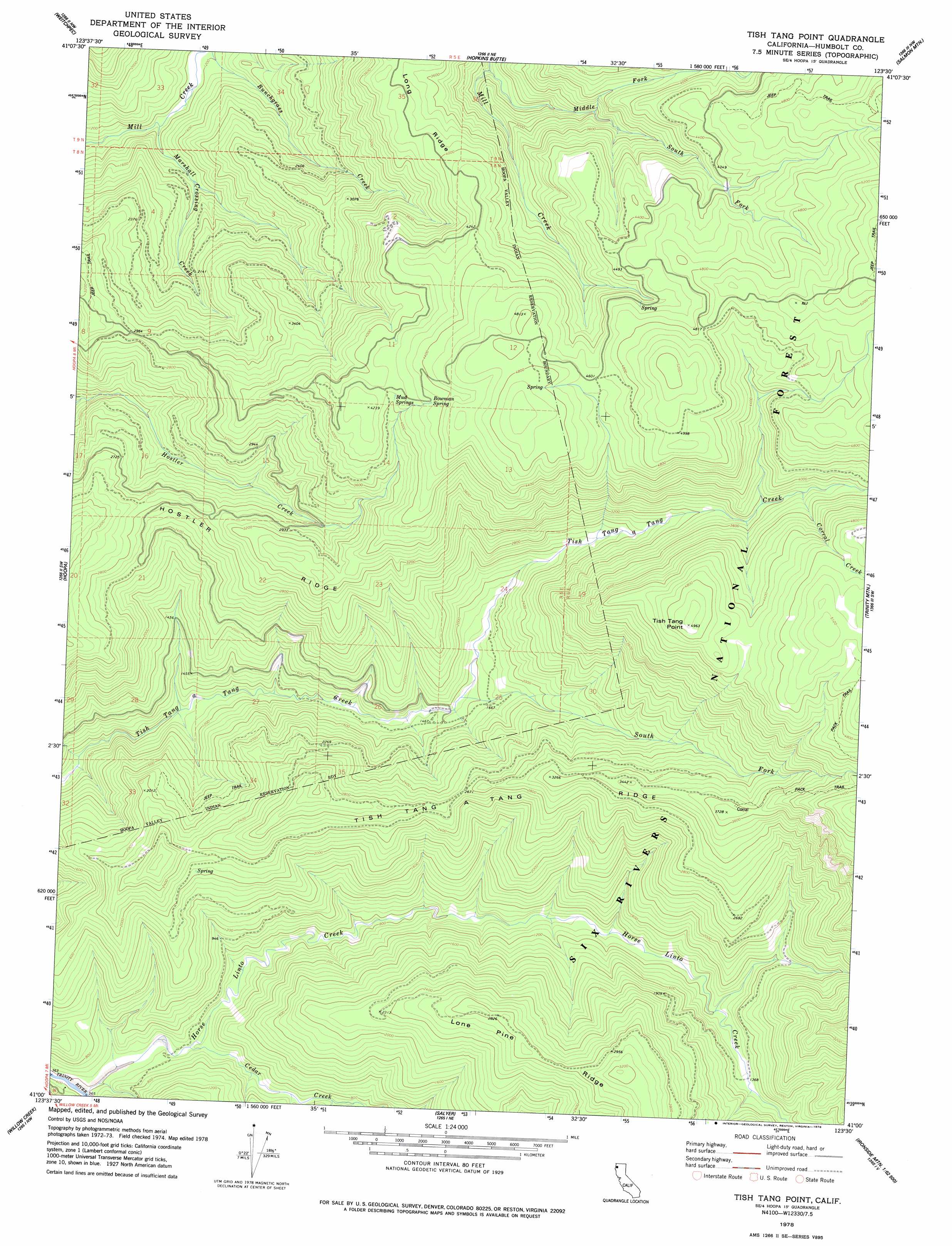
USGS Topo Quad 41123a5 - 1:24,000 scale
| Topo Map Name: | Tish Tang Point |
| USGS Topo Quad ID: | 41123a5 |
| Print Size: | ca. 21 1/4" wide x 27" high |
| Southeast Coordinates: | 41° N latitude / 123.5° W longitude |
| Map Center Coordinates: | 41.0625° N latitude / 123.5625° W longitude |
| U.S. State: | CA |
| Filename: | o41123a5.jpg |
| Download Map JPG Image: | Tish Tang Point topo map 1:24,000 scale |
| Map Type: | Topographic |
| Topo Series: | 7.5´ |
| Map Scale: | 1:24,000 |
| Source of Map Images: | United States Geological Survey (USGS) |
| Alternate Map Versions: |
Tish Tang Point CA 1978, updated 1978 Download PDF Buy paper map Tish Tang Point CA 1997, updated 2001 Download PDF Buy paper map Tish Tang Point CA 2012 Download PDF Buy paper map Tish Tang Point CA 2015 Download PDF Buy paper map |
| FStopo: | US Forest Service topo Tish Tang Point is available: Download FStopo PDF Download FStopo TIF |
1:24,000 Topo Quads surrounding Tish Tang Point
Johnsons |
Fish Lake |
Orleans |
Orleans Mountain |
Forks Of Salmon |
French Camp Ridge |
Weitchpec |
Hopkins Butte |
Salmon Mountain |
Youngs Peak |
Hupa Mountain |
Hoopa |
Tish Tang Point |
Trinity Mountain |
Dees Peak |
Lord-Ellis Summit |
Willow Creek |
Salyer |
Denny |
Jim Jam Ridge |
Maple Creek |
Grouse Mountain |
Hennessy Peak |
Ironside Mountain |
Del Loma |
> Back to 41123a1 at 1:100,000 scale
> Back to 41122a1 at 1:250,000 scale
> Back to U.S. Topo Maps home
Tish Tang Point topo map: Gazetteer
Tish Tang Point: Capes
Tish Tang Point elevation 1516m 4973′Tish Tang Point: Forests
Six Rivers National Forest elevation 611m 2004′Tish Tang Point: Ridges
Hostler Ridge elevation 1030m 3379′Long Ridge elevation 1176m 3858′
Tish Tang a Tang Ridge elevation 1053m 3454′
Tish Tang Point: Springs
Bowman Spring elevation 1318m 4324′Mud Springs elevation 1245m 4084′
Tish Tang Point: Streams
Cedar Creek elevation 143m 469′Corral Creek elevation 1126m 3694′
Domingo Creek elevation 787m 2582′
Horse Linto Creek elevation 119m 390′
Marshall Crossing Creek elevation 335m 1099′
South Fork Domingo Creek elevation 953m 3126′
South Fork Tish Tang a Tang Creek elevation 459m 1505′
Tish Tang Point digital topo map on disk
Buy this Tish Tang Point topo map showing relief, roads, GPS coordinates and other geographical features, as a high-resolution digital map file on DVD: