Hupa Mountain Topo Map California
To zoom in, hover over the map of Hupa Mountain
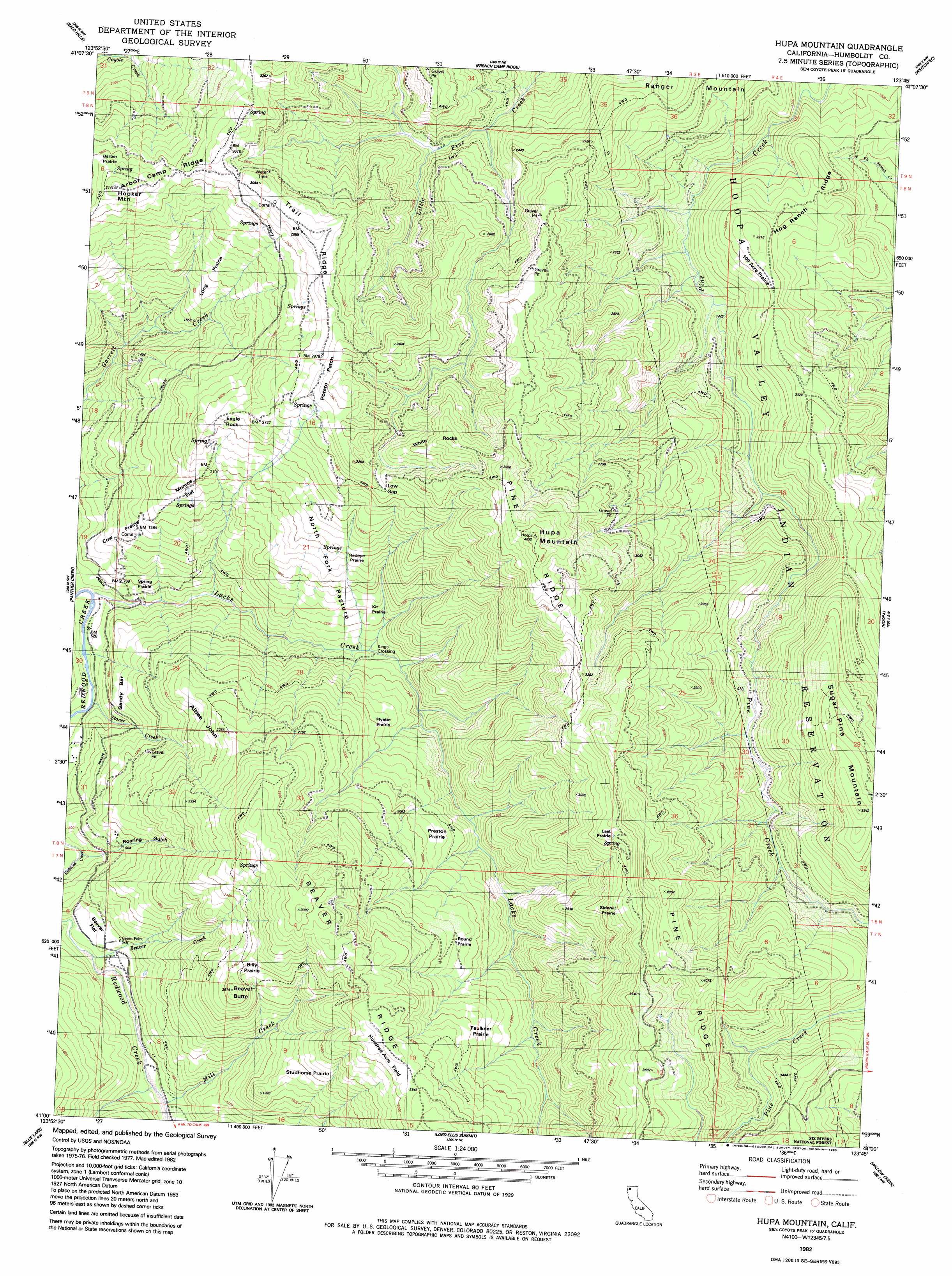
USGS Topo Quad 41123a7 - 1:24,000 scale
| Topo Map Name: | Hupa Mountain |
| USGS Topo Quad ID: | 41123a7 |
| Print Size: | ca. 21 1/4" wide x 27" high |
| Southeast Coordinates: | 41° N latitude / 123.75° W longitude |
| Map Center Coordinates: | 41.0625° N latitude / 123.8125° W longitude |
| U.S. State: | CA |
| Filename: | o41123a7.jpg |
| Download Map JPG Image: | Hupa Mountain topo map 1:24,000 scale |
| Map Type: | Topographic |
| Topo Series: | 7.5´ |
| Map Scale: | 1:24,000 |
| Source of Map Images: | United States Geological Survey (USGS) |
| Alternate Map Versions: |
Hupa Mountain CA 1982, updated 1983 Download PDF Buy paper map Hupa Mountain CA 1997, updated 2001 Download PDF Buy paper map Hupa Mountain CA 2012 Download PDF Buy paper map Hupa Mountain CA 2015 Download PDF Buy paper map |
| FStopo: | US Forest Service topo Hupa Mountain is available: Download FStopo PDF Download FStopo TIF |
1:24,000 Topo Quads surrounding Hupa Mountain
Orick |
Holter Ridge |
Johnsons |
Fish Lake |
Orleans |
Rodgers Peak |
Bald Hills |
French Camp Ridge |
Weitchpec |
Hopkins Butte |
Crannell |
Panther Creek |
Hupa Mountain |
Hoopa |
Tish Tang Point |
Arcata North |
Blue Lake |
Lord-Ellis Summit |
Willow Creek |
Salyer |
Arcata South |
Korbel |
Maple Creek |
Grouse Mountain |
Hennessy Peak |
> Back to 41123a1 at 1:100,000 scale
> Back to 41122a1 at 1:250,000 scale
> Back to U.S. Topo Maps home
Hupa Mountain topo map: Gazetteer
Hupa Mountain: Areas
Billy Prairie elevation 731m 2398′Faulkner Prairie elevation 696m 2283′
Flyette Prairie elevation 464m 1522′
Kit Prairie elevation 422m 1384′
Last Prairie elevation 1020m 3346′
Long Prairie elevation 632m 2073′
North Fork Pasture elevation 562m 1843′
Onehundred Acre Prairie elevation 657m 2155′
Potato Patch elevation 956m 3136′
Preston Prairie elevation 560m 1837′
Redeye Prairie elevation 601m 1971′
Round Prairie elevation 658m 2158′
Sandy Bar elevation 301m 987′
Sidehill Prairie elevation 992m 3254′
Spring Prairie elevation 255m 836′
Studhorse Prairie elevation 617m 2024′
Hupa Mountain: Crossings
Kings Crossing elevation 290m 951′Hupa Mountain: Flats
Beaver Flat elevation 218m 715′Cow Prairie elevation 340m 1115′
Hundred Acre Flat elevation 895m 2936′
Monroe Flat elevation 523m 1715′
Hupa Mountain: Gaps
Low Gap elevation 901m 2956′Hupa Mountain: Pillars
Eagle Rock elevation 760m 2493′Hupa Mountain: Ridges
Arbor Camp Ridge elevation 929m 3047′Beaver Ridge elevation 897m 2942′
Hog Ranch Ridge elevation 444m 1456′
Pine Ridge elevation 1248m 4094′
Trail Ridge elevation 930m 3051′
Hupa Mountain: Streams
Beaver Creek elevation 197m 646′Lacks Creek elevation 148m 485′
Mill Creek elevation 198m 649′
Stover Creek elevation 167m 547′
Hupa Mountain: Summits
Beaver Butte elevation 788m 2585′Hooker Mountain elevation 957m 3139′
Hupa Mountain elevation 1239m 4064′
White Rocks elevation 1098m 3602′
Hupa Mountain: Valleys
Roaring Gulch elevation 241m 790′Hupa Mountain digital topo map on disk
Buy this Hupa Mountain topo map showing relief, roads, GPS coordinates and other geographical features, as a high-resolution digital map file on DVD: