Orleans Topo Map California
To zoom in, hover over the map of Orleans
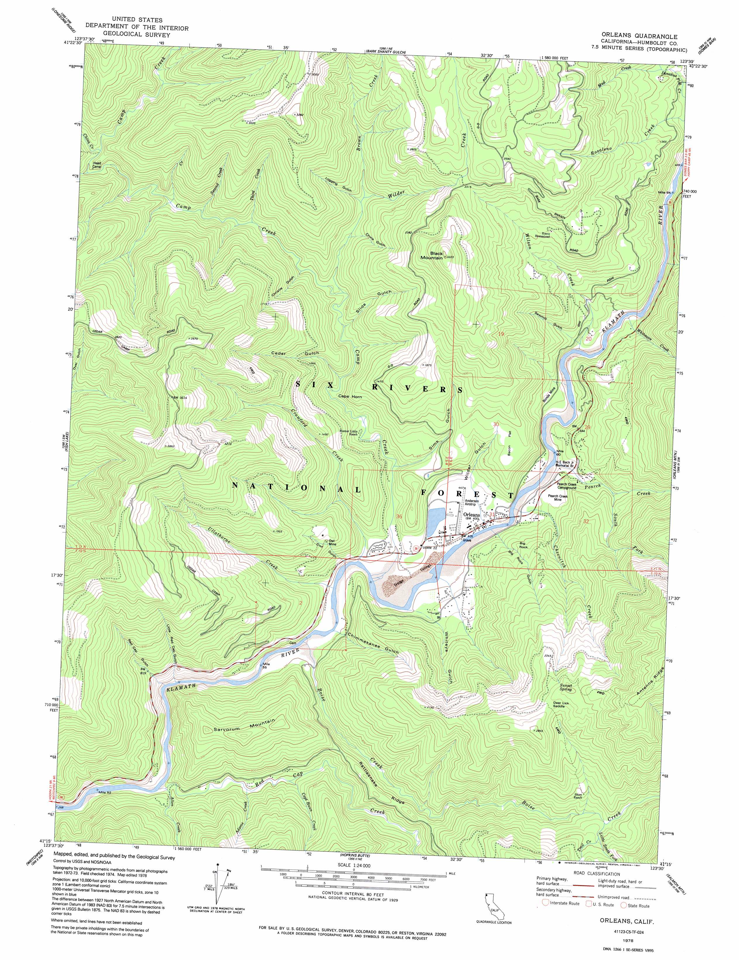
USGS Topo Quad 41123c5 - 1:24,000 scale
| Topo Map Name: | Orleans |
| USGS Topo Quad ID: | 41123c5 |
| Print Size: | ca. 21 1/4" wide x 27" high |
| Southeast Coordinates: | 41.25° N latitude / 123.5° W longitude |
| Map Center Coordinates: | 41.3125° N latitude / 123.5625° W longitude |
| U.S. State: | CA |
| Filename: | o41123c5.jpg |
| Download Map JPG Image: | Orleans topo map 1:24,000 scale |
| Map Type: | Topographic |
| Topo Series: | 7.5´ |
| Map Scale: | 1:24,000 |
| Source of Map Images: | United States Geological Survey (USGS) |
| Alternate Map Versions: |
Orleans CA 1978, updated 1979 Download PDF Buy paper map Orleans CA 1978, updated 1991 Download PDF Buy paper map Orleans CA 1997, updated 2001 Download PDF Buy paper map Orleans CA 2012 Download PDF Buy paper map Orleans CA 2015 Download PDF Buy paper map |
| FStopo: | US Forest Service topo Orleans is available: Download FStopo PDF Download FStopo TIF |
1:24,000 Topo Quads surrounding Orleans
Summit Valley |
Chimney Rock |
Dillon Mountain |
Ukonom Mountain |
Ukonom Lake |
Blue Creek Mountain |
Lonesome Ridge |
Bark Shanty Gulch |
Somes Bar |
Medicine Mountain |
Johnsons |
Fish Lake |
Orleans |
Orleans Mountain |
Forks Of Salmon |
French Camp Ridge |
Weitchpec |
Hopkins Butte |
Salmon Mountain |
Youngs Peak |
Hupa Mountain |
Hoopa |
Tish Tang Point |
Trinity Mountain |
Dees Peak |
> Back to 41123a1 at 1:100,000 scale
> Back to 41122a1 at 1:250,000 scale
> Back to U.S. Topo Maps home
Orleans topo map: Gazetteer
Orleans: Capes
Cape Horn elevation 173m 567′Orleans: Flats
Bacon Flat elevation 327m 1072′Orleans: Gaps
Deer Lick Saddle elevation 791m 2595′Orleans: Mines
Bonda Mine elevation 178m 583′McHale Mine elevation 134m 439′
Owl Mine elevation 362m 1187′
Pearch Creek Mine elevation 168m 551′
Orleans: Parks
H E Beck Junior Memorial Branch elevation 154m 505′Orleans: Pillars
Big Rock elevation 274m 898′Orleans: Populated Places
Dyer Place (historical) elevation 859m 2818′Opegoi (historical) elevation 104m 341′
Orleans elevation 123m 403′
Panamenik (historical) elevation 126m 413′
Orleans: Ridges
Rattlesnake Ridge elevation 322m 1056′Orleans: Springs
Sunset Spring elevation 778m 2552′Orleans: Streams
Adams Creek elevation 114m 374′Allen Creek elevation 95m 311′
Boise Creek elevation 98m 321′
Brown Creek elevation 343m 1125′
Camp Creek elevation 103m 337′
Captain Haun Creek elevation 121m 396′
Cedar Creek elevation 362m 1187′
Cheenitch Creek elevation 109m 357′
China Creek elevation 380m 1246′
Crawford Creek elevation 110m 360′
First Creek elevation 288m 944′
Fivemile Creek elevation 122m 400′
Little South Fork Boise Creek elevation 420m 1377′
Mud Creek elevation 354m 1161′
Pearch Creek elevation 119m 390′
Red Cap Creek elevation 87m 285′
Second Creek elevation 275m 902′
South Fork Pearch Creek elevation 215m 705′
Third Creek elevation 250m 820′
Trail Creek elevation 451m 1479′
Ullathorne Creek elevation 113m 370′
Whitmore Creek elevation 119m 390′
Wilder Creek elevation 213m 698′
Wilson Creek elevation 121m 396′
Orleans: Summits
Black Mountain elevation 957m 3139′Sarvorum Mountain elevation 562m 1843′
Orleans: Valleys
Big Rock Gulch elevation 153m 501′Cedar Gulch elevation 234m 767′
Chimmekanee Gulch elevation 118m 387′
China Gulch elevation 282m 925′
Christie Gulch elevation 289m 948′
Little Red Cap Gulch elevation 117m 383′
Logging Gulch elevation 373m 1223′
Owl Gulch elevation 170m 557′
Red Cap Gulch elevation 230m 754′
Sawmill Gulch elevation 189m 620′
Sims Gulch elevation 141m 462′
Slide Gulch elevation 201m 659′
Whiteys Gulch elevation 138m 452′
Wilder Gulch elevation 143m 469′
Orleans digital topo map on disk
Buy this Orleans topo map showing relief, roads, GPS coordinates and other geographical features, as a high-resolution digital map file on DVD: