Dillon Mountain Topo Map California
To zoom in, hover over the map of Dillon Mountain
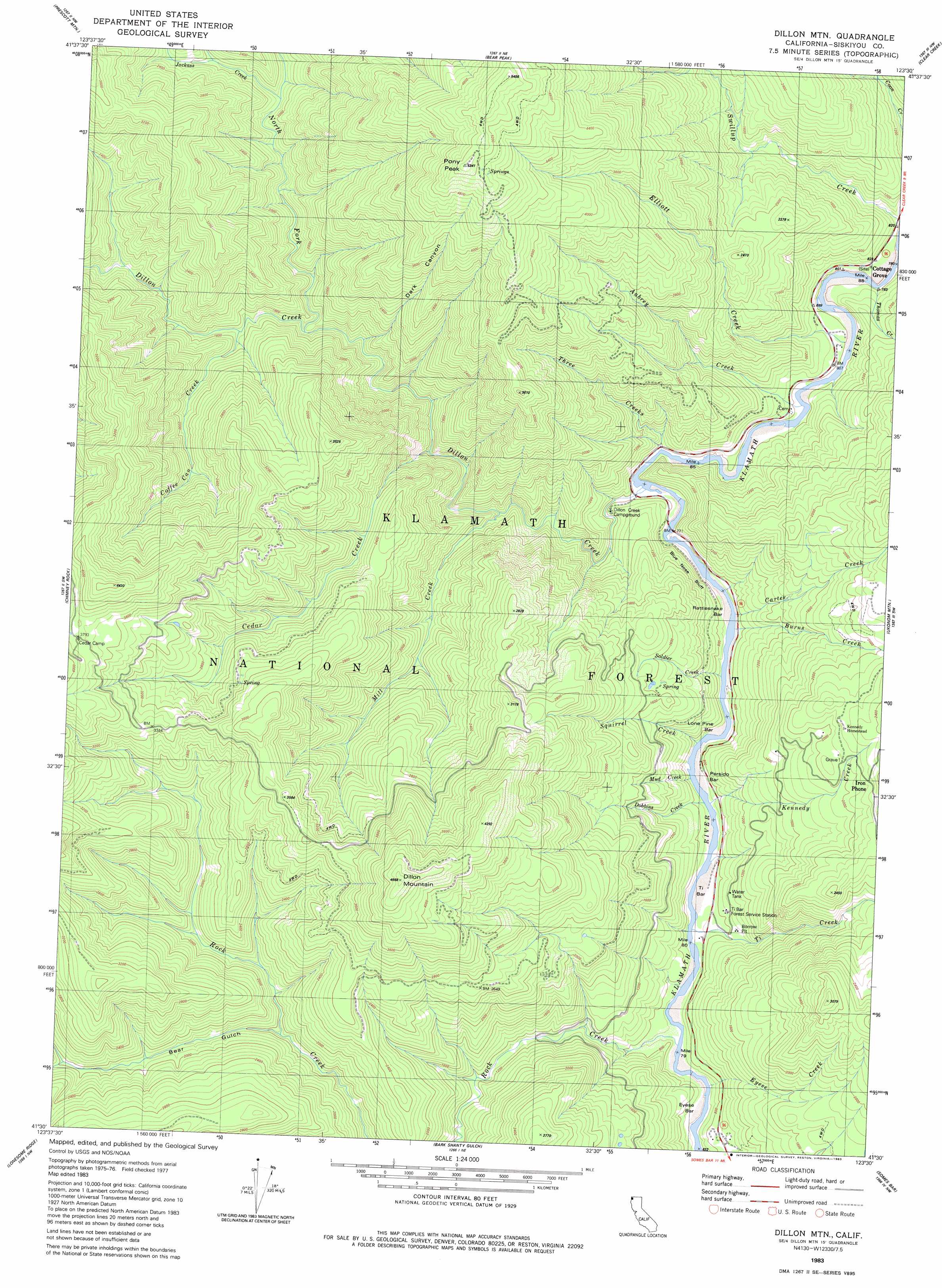
USGS Topo Quad 41123e5 - 1:24,000 scale
| Topo Map Name: | Dillon Mountain |
| USGS Topo Quad ID: | 41123e5 |
| Print Size: | ca. 21 1/4" wide x 27" high |
| Southeast Coordinates: | 41.5° N latitude / 123.5° W longitude |
| Map Center Coordinates: | 41.5625° N latitude / 123.5625° W longitude |
| U.S. State: | CA |
| Filename: | o41123e5.jpg |
| Download Map JPG Image: | Dillon Mountain topo map 1:24,000 scale |
| Map Type: | Topographic |
| Topo Series: | 7.5´ |
| Map Scale: | 1:24,000 |
| Source of Map Images: | United States Geological Survey (USGS) |
| Alternate Map Versions: |
Dillon Mtn CA 1983, updated 1983 Download PDF Buy paper map Dillon Mtn CA 1983, updated 1983 Download PDF Buy paper map Dillon Mountain CA 2001, updated 2004 Download PDF Buy paper map Dillon Mtn CA 2001, updated 2004 Download PDF Buy paper map Dillon Mountain CA 2012 Download PDF Buy paper map Dillon Mountain CA 2015 Download PDF Buy paper map |
| FStopo: | US Forest Service topo Dillon Mountain is available: Download FStopo PDF Download FStopo TIF |
1:24,000 Topo Quads surrounding Dillon Mountain
Hurdygurdy Butte |
Devils Punchbowl |
Preston Peak |
Happy Camp |
Slater Butte |
Ship Mountain |
Prescott Mountain |
Bear Peak |
Clear Creek |
Huckleberry Mountain |
Summit Valley |
Chimney Rock |
Dillon Mountain |
Ukonom Mountain |
Ukonom Lake |
Blue Creek Mountain |
Lonesome Ridge |
Bark Shanty Gulch |
Somes Bar |
Medicine Mountain |
Johnsons |
Fish Lake |
Orleans |
Orleans Mountain |
Forks Of Salmon |
> Back to 41123e1 at 1:100,000 scale
> Back to 41122a1 at 1:250,000 scale
> Back to U.S. Topo Maps home
Dillon Mountain topo map: Gazetteer
Dillon Mountain: Bars
Eyese Bar elevation 204m 669′Lone Pine Bar elevation 205m 672′
Persido Bar elevation 197m 646′
Rattlesnake Bar elevation 221m 725′
Ti Bar elevation 200m 656′
Dillon Mountain: Cliffs
Blue Nose Bluff elevation 305m 1000′Dillon Mountain: Mines
Blue Nose Mine elevation 277m 908′Dillon Mountain: Populated Places
Cottage Grove elevation 265m 869′Eyese Bar (historical) elevation 221m 725′
Patsiluvra (historical) elevation 224m 734′
Dillon Mountain: Streams
Aubrey Creek elevation 225m 738′Burns Creek elevation 196m 643′
Carter Creek elevation 196m 643′
Cedar Creek elevation 357m 1171′
Coffee Can Creek elevation 461m 1512′
Dillon Creek elevation 224m 734′
Dobbins Creek elevation 195m 639′
Elliott Creek elevation 220m 721′
Eyese Creek elevation 173m 567′
Jackass Creek elevation 561m 1840′
Kennedy Creek elevation 196m 643′
Mill Creek elevation 289m 948′
Mud Creek elevation 229m 751′
North Fork Dillon Creek elevation 446m 1463′
Soldier Creek elevation 205m 672′
Squirrel Creek elevation 253m 830′
Swillup Creek elevation 263m 862′
Thomas Creek elevation 223m 731′
Three Creeks elevation 236m 774′
Ti Creek elevation 197m 646′
Dillon Mountain: Summits
Dillon Mountain elevation 1421m 4662′Pony Peak elevation 1594m 5229′
Dillon Mountain: Valleys
Bear Gulch elevation 474m 1555′Dark Canyon elevation 452m 1482′
Dillon Mountain digital topo map on disk
Buy this Dillon Mountain topo map showing relief, roads, GPS coordinates and other geographical features, as a high-resolution digital map file on DVD: