Grider Valley Topo Map California
To zoom in, hover over the map of Grider Valley
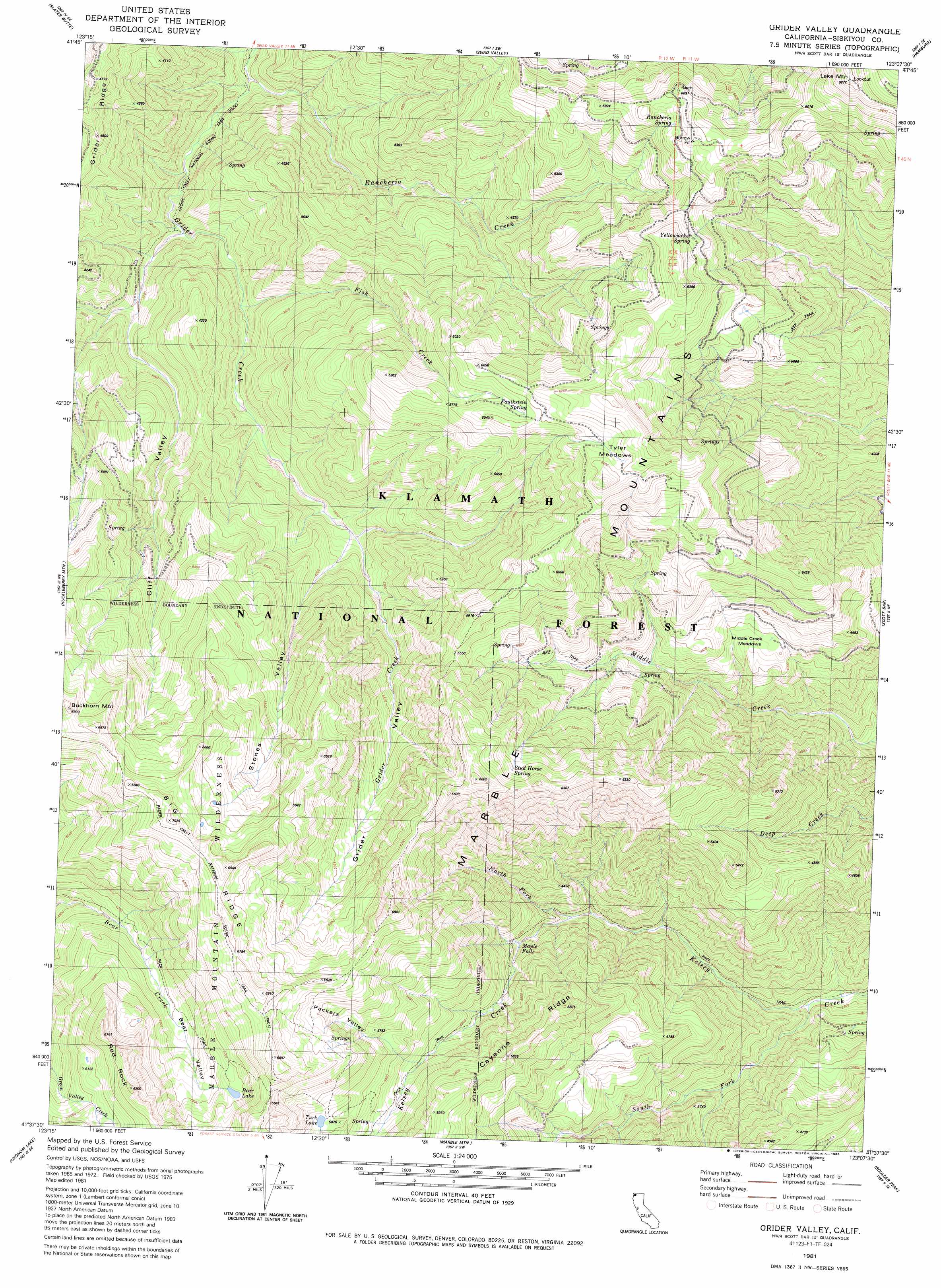
USGS Topo Quad 41123f2 - 1:24,000 scale
| Topo Map Name: | Grider Valley |
| USGS Topo Quad ID: | 41123f2 |
| Print Size: | ca. 21 1/4" wide x 27" high |
| Southeast Coordinates: | 41.625° N latitude / 123.125° W longitude |
| Map Center Coordinates: | 41.6875° N latitude / 123.1875° W longitude |
| U.S. State: | CA |
| Filename: | o41123f2.jpg |
| Download Map JPG Image: | Grider Valley topo map 1:24,000 scale |
| Map Type: | Topographic |
| Topo Series: | 7.5´ |
| Map Scale: | 1:24,000 |
| Source of Map Images: | United States Geological Survey (USGS) |
| Alternate Map Versions: |
Grider Valley CA 1981, updated 1981 Download PDF Buy paper map Grider Valley CA 1981, updated 1986 Download PDF Buy paper map Grider Valley CA 2001, updated 2004 Download PDF Buy paper map Grider Valley CA 2012 Download PDF Buy paper map Grider Valley CA 2015 Download PDF Buy paper map |
| FStopo: | US Forest Service topo Grider Valley is available: Download FStopo PDF Download FStopo TIF |
1:24,000 Topo Quads surrounding Grider Valley
Deadman Point |
Figurehead Mountain |
Kangaroo Mountain |
Dutch Creek |
Condrey Mountain |
Happy Camp |
Slater Butte |
Seiad Valley |
Hamburg |
Horse Creek |
Clear Creek |
Huckleberry Mountain |
Grider Valley |
Scott Bar |
Russell Peak |
Ukonom Mountain |
Ukonom Lake |
Marble Mountain |
Boulder Peak |
Greenview |
Somes Bar |
Medicine Mountain |
English Peak |
Yellow Dog Peak |
Etna |
> Back to 41123e1 at 1:100,000 scale
> Back to 41122a1 at 1:250,000 scale
> Back to U.S. Topo Maps home
Grider Valley topo map: Gazetteer
Grider Valley: Falls
Maple Falls elevation 1311m 4301′Grider Valley: Flats
Middle Creek Meadows elevation 1274m 4179′Tyler Meadows elevation 1823m 5980′
Grider Valley: Lakes
Bear Lake elevation 1819m 5967′Turk Lake elevation 1775m 5823′
Grider Valley: Pillars
Red Rock elevation 2038m 6686′Grider Valley: Ridges
Big Ridge elevation 2089m 6853′Cayenne Ridge elevation 1757m 5764′
Grider Ridge elevation 1461m 4793′
Grider Valley: Springs
Faulkstein Spring elevation 1817m 5961′Rancheria Spring elevation 1803m 5915′
Stud Horse Spring elevation 1845m 6053′
Yellow Jacket Spring elevation 1767m 5797′
Grider Valley: Streams
Fish Creek elevation 978m 3208′North Fork Kelsey Creek elevation 1115m 3658′
Rancheria Creek elevation 820m 2690′
South Fork Kelsey Creek elevation 797m 2614′
Grider Valley: Summits
Lake Mountain elevation 2085m 6840′Grider Valley: Valleys
Bear Valley elevation 1595m 5232′Cliff Valley elevation 915m 3001′
Grider Valley elevation 1522m 4993′
Packers Valley elevation 1563m 5127′
Stones Valley elevation 1173m 3848′
Grider Valley digital topo map on disk
Buy this Grider Valley topo map showing relief, roads, GPS coordinates and other geographical features, as a high-resolution digital map file on DVD: