Seiad Valley Topo Map California
To zoom in, hover over the map of Seiad Valley
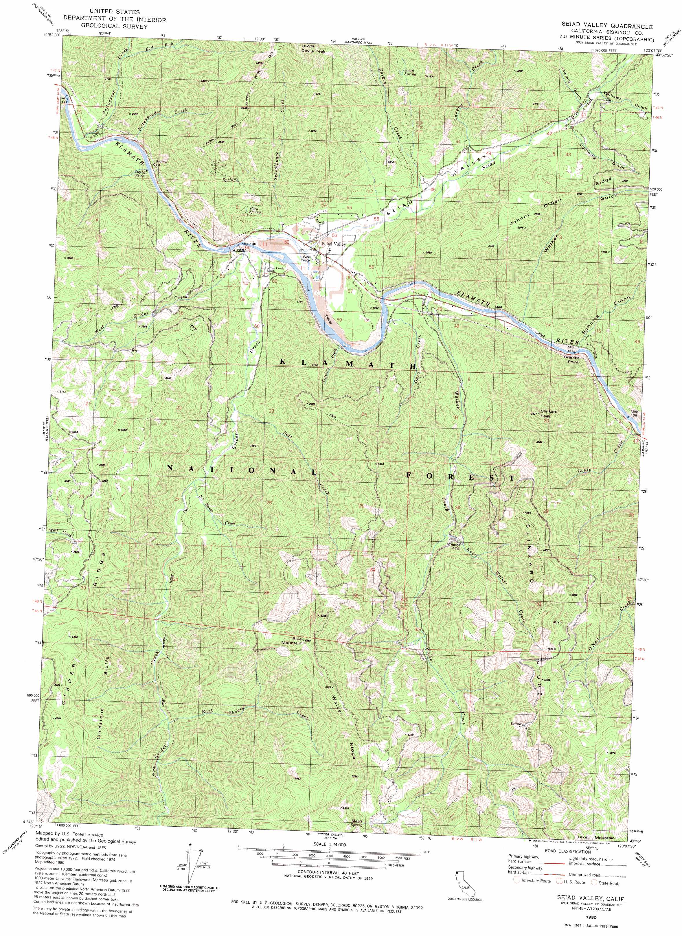
USGS Topo Quad 41123g2 - 1:24,000 scale
| Topo Map Name: | Seiad Valley |
| USGS Topo Quad ID: | 41123g2 |
| Print Size: | ca. 21 1/4" wide x 27" high |
| Southeast Coordinates: | 41.75° N latitude / 123.125° W longitude |
| Map Center Coordinates: | 41.8125° N latitude / 123.1875° W longitude |
| U.S. State: | CA |
| Filename: | o41123g2.jpg |
| Download Map JPG Image: | Seiad Valley topo map 1:24,000 scale |
| Map Type: | Topographic |
| Topo Series: | 7.5´ |
| Map Scale: | 1:24,000 |
| Source of Map Images: | United States Geological Survey (USGS) |
| Alternate Map Versions: |
Seiad Valley CA 1980, updated 1981 Download PDF Buy paper map Seiad Valley CA 1980, updated 1988 Download PDF Buy paper map Seiad Valley CA 2001, updated 2004 Download PDF Buy paper map Seiad Valley CA 2012 Download PDF Buy paper map Seiad Valley CA 2015 Download PDF Buy paper map |
| FStopo: | US Forest Service topo Seiad Valley is available: Download FStopo PDF Download FStopo TIF |
1:24,000 Topo Quads surrounding Seiad Valley
Oregon Caves |
Grayback Mountain |
Carberry Creek |
Squaw Lakes |
Dutchman Peak |
Deadman Point |
Figurehead Mountain |
Kangaroo Mountain |
Dutch Creek |
Condrey Mountain |
Happy Camp |
Slater Butte |
Seiad Valley |
Hamburg |
Horse Creek |
Clear Creek |
Huckleberry Mountain |
Grider Valley |
Scott Bar |
Russell Peak |
Ukonom Mountain |
Ukonom Lake |
Marble Mountain |
Boulder Peak |
Greenview |
> Back to 41123e1 at 1:100,000 scale
> Back to 41122a1 at 1:250,000 scale
> Back to U.S. Topo Maps home
Seiad Valley topo map: Gazetteer
Seiad Valley: Capes
Granite Point elevation 461m 1512′Seiad Valley: Cliffs
Limestone Bluffs elevation 1027m 3369′Seiad Valley: Populated Places
Seiad Valley elevation 432m 1417′Seiad Valley: Ridges
Slinkard Ridge elevation 1515m 4970′Walker Ridge elevation 1586m 5203′
Seiad Valley: Springs
Fern Spring elevation 571m 1873′Maple Spring elevation 1625m 5331′
Quail Spring elevation 918m 3011′
Seiad Valley: Streams
Bark Shanty Creek elevation 701m 2299′Bittenbender Creek elevation 409m 1341′
Canyon Creek elevation 476m 1561′
Caroline Creek elevation 428m 1404′
Darkey Creek elevation 459m 1505′
East Fork Portuguese Creek elevation 511m 1676′
East Walker Creek elevation 694m 2276′
Gard Creek elevation 422m 1384′
Grider Creek elevation 415m 1361′
Louie Creek elevation 438m 1437′
No Name Creek elevation 524m 1719′
Portuguese Creek elevation 403m 1322′
Salt Creek elevation 484m 1587′
Schoolhouse Creek elevation 420m 1377′
Seiad Creek elevation 419m 1374′
Walker Creek elevation 431m 1414′
West Grider Creek elevation 414m 1358′
Seiad Valley: Summits
Blue Mountain elevation 1590m 5216′Slinkard Peak elevation 1140m 3740′
Seiad Valley: Valleys
Lightning Gulch elevation 544m 1784′Sawmill Gulch elevation 586m 1922′
Schutts Gulch elevation 484m 1587′
Seiad Valley elevation 427m 1400′
Walker Gulch elevation 479m 1571′
Williams Gulch elevation 566m 1856′
Seiad Valley digital topo map on disk
Buy this Seiad Valley topo map showing relief, roads, GPS coordinates and other geographical features, as a high-resolution digital map file on DVD: