Slater Butte Topo Map California
To zoom in, hover over the map of Slater Butte
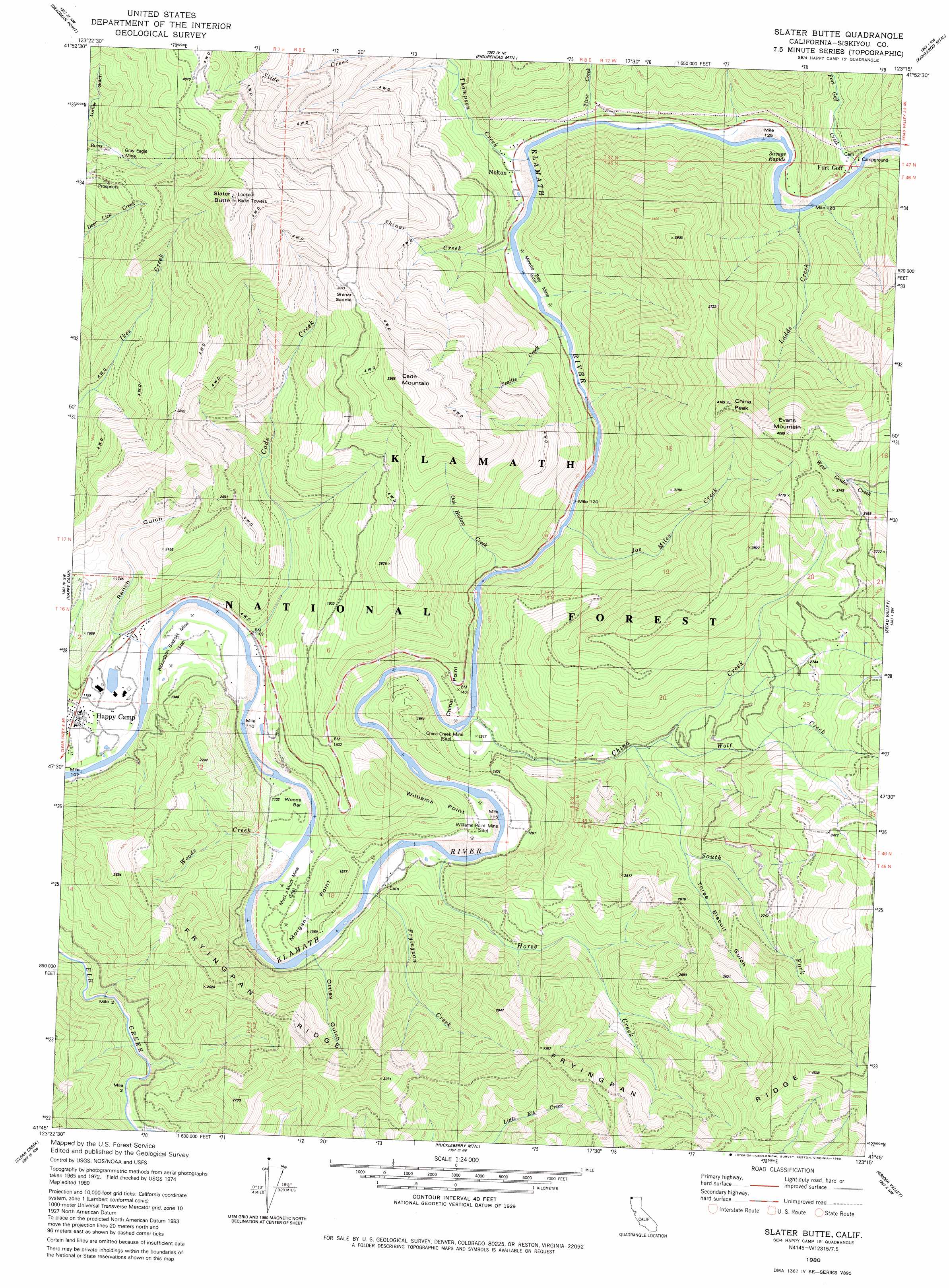
USGS Topo Quad 41123g3 - 1:24,000 scale
| Topo Map Name: | Slater Butte |
| USGS Topo Quad ID: | 41123g3 |
| Print Size: | ca. 21 1/4" wide x 27" high |
| Southeast Coordinates: | 41.75° N latitude / 123.25° W longitude |
| Map Center Coordinates: | 41.8125° N latitude / 123.3125° W longitude |
| U.S. State: | CA |
| Filename: | o41123g3.jpg |
| Download Map JPG Image: | Slater Butte topo map 1:24,000 scale |
| Map Type: | Topographic |
| Topo Series: | 7.5´ |
| Map Scale: | 1:24,000 |
| Source of Map Images: | United States Geological Survey (USGS) |
| Alternate Map Versions: |
Slater Butte CA 1980, updated 1980 Download PDF Buy paper map Slater Butte CA 2001, updated 2004 Download PDF Buy paper map Slater Butte CA 2012 Download PDF Buy paper map Slater Butte CA 2015 Download PDF Buy paper map |
| FStopo: | US Forest Service topo Slater Butte is available: Download FStopo PDF Download FStopo TIF |
1:24,000 Topo Quads surrounding Slater Butte
Takilma |
Oregon Caves |
Grayback Mountain |
Carberry Creek |
Squaw Lakes |
Polar Bear Mountain |
Deadman Point |
Figurehead Mountain |
Kangaroo Mountain |
Dutch Creek |
Preston Peak |
Happy Camp |
Slater Butte |
Seiad Valley |
Hamburg |
Bear Peak |
Clear Creek |
Huckleberry Mountain |
Grider Valley |
Scott Bar |
Dillon Mountain |
Ukonom Mountain |
Ukonom Lake |
Marble Mountain |
Boulder Peak |
> Back to 41123e1 at 1:100,000 scale
> Back to 41122a1 at 1:250,000 scale
> Back to U.S. Topo Maps home
Slater Butte topo map: Gazetteer
Slater Butte: Bars
Woods Bar elevation 335m 1099′Slater Butte: Capes
China Point elevation 368m 1207′Morgan Point elevation 402m 1318′
Williams Point elevation 358m 1174′
Slater Butte: Crossings
Gordons Ferry (historical) elevation 337m 1105′Slater Butte: Gaps
Shinar Saddle elevation 928m 3044′Slater Butte: Mines
Bonetta Bee Mine elevation 372m 1220′China Creek Mine elevation 364m 1194′
Grey Eagle Mine elevation 755m 2477′
Muck a Muck Mine elevation 358m 1174′
Reeves Mine elevation 346m 1135′
Richardson Bedrock Mine elevation 333m 1092′
Williams Point Mine elevation 350m 1148′
Slater Butte: Populated Places
Fort Goff elevation 499m 1637′Slater Butte: Rapids
Savage Rapids elevation 385m 1263′Slater Butte: Ridges
Fryingpan Ridge elevation 914m 2998′Slater Butte: Streams
Cade Creek elevation 329m 1079′China Creek elevation 356m 1167′
Fort Goff Creek elevation 395m 1295′
Fryingpan Creek elevation 335m 1099′
Horse Creek elevation 344m 1128′
Joe Miles Creek elevation 378m 1240′
Ladds Creek elevation 402m 1318′
Oak Hollow Creek elevation 362m 1187′
Seattle Creek elevation 374m 1227′
Shinar Creek elevation 372m 1220′
South Fork China Creek elevation 452m 1482′
Thompson Creek elevation 377m 1236′
Tims Creek elevation 379m 1243′
Wolf Creek elevation 481m 1578′
Woods Creek elevation 337m 1105′
Slater Butte: Summits
Cade Mountain elevation 1178m 3864′China Peak elevation 1264m 4146′
Evans Mountain elevation 1289m 4229′
Slater Butte elevation 1391m 4563′
Slater Butte: Valleys
Ottley Gulch elevation 361m 1184′Ranch Gulch elevation 367m 1204′
Three Biscuit Gulch elevation 609m 1998′
Slater Butte digital topo map on disk
Buy this Slater Butte topo map showing relief, roads, GPS coordinates and other geographical features, as a high-resolution digital map file on DVD: