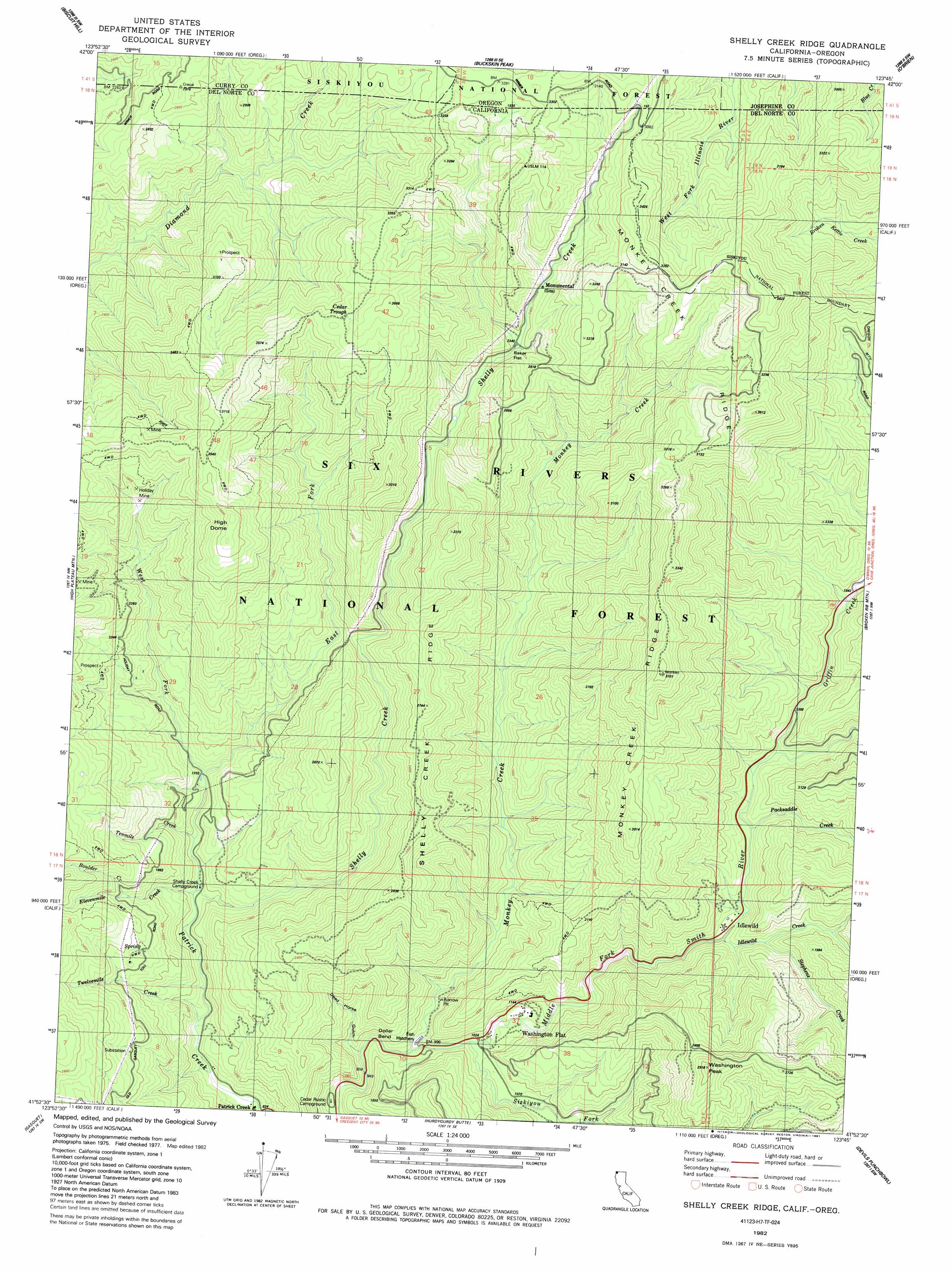
Shelly Creek Ridge Topo Map California
To zoom in, hover over the map of Shelly Creek Ridge
USGS Topo Quad 41123h7 - 1:24,000 scale
| Topo Map Name: | Shelly Creek Ridge |
| USGS Topo Quad ID: | 41123h7 |
| Print Size: | ca. 21 1/4" wide x 27" high |
| Southeast Coordinates: | 41.875° N latitude / 123.75° W longitude |
| Map Center Coordinates: | 41.9375° N latitude / 123.8125° W longitude |
| U.S. States: | CA, OR |
| Filename: | o41123h7.jpg |
| Download Map JPG Image: | Shelly Creek Ridge topo map 1:24,000 scale |
| Map Type: | Topographic |
| Topo Series: | 7.5´ |
| Map Scale: | 1:24,000 |
| Source of Map Images: | United States Geological Survey (USGS) |
| Alternate Map Versions: |
Shelly Creek Ridge CA 1982, updated 1983 Download PDF Buy paper map Shelly Creek Ridge CA 1982, updated 1991 Download PDF Buy paper map Shelly Creek Ridge CA 1997, updated 2001 Download PDF Buy paper map Shelly Creek Ridge CA 2012 Download PDF Buy paper map Shelly Creek Ridge CA 2015 Download PDF Buy paper map |
| FStopo: | US Forest Service topo Shelly Creek Ridge is available: Download FStopo PDF Download FStopo TIF |
1:24,000 Topo Quads surrounding Shelly Creek Ridge
Quail Prairie Mountain |
Chetco Peak |
Josephine Mountain |
Cave Junction |
Holland |
Fourth Of July Creek |
Biscuit Hill |
Buckskin Peak |
O'Brien |
Takilma |
High Divide |
High Plateau Mountain |
Shelly Creek Ridge |
Broken Rib Mountain |
Polar Bear Mountain |
Hiouchi |
Gasquet |
Hurdygurdy Butte |
Devils Punchbowl |
Preston Peak |
Childs Hill |
Cant Hook Mountain |
Ship Mountain |
Prescott Mountain |
Bear Peak |
> Back to 41123e1 at 1:100,000 scale
> Back to 41122a1 at 1:250,000 scale
> Back to U.S. Topo Maps home
Shelly Creek Ridge topo map: Gazetteer
Shelly Creek Ridge: Bends
Dollar Bend elevation 319m 1046′Shelly Creek Ridge: Flats
Baker Flat elevation 717m 2352′Horse Flat elevation 430m 1410′
Washington Flat elevation 334m 1095′
Shelly Creek Ridge: Mines
Blue Rock Mine elevation 732m 2401′Continental Mine elevation 857m 2811′
Holiday Mine elevation 791m 2595′
Logan Mine elevation 924m 3031′
Richey Mine elevation 814m 2670′
Shelly Creek Ridge: Populated Places
Idlewild elevation 383m 1256′Patrick Creek elevation 257m 843′
Shelly Creek Ridge: Ridges
Monkey Creek Ridge elevation 994m 3261′Shelly Creek Ridge elevation 719m 2358′
Shelly Creek Ridge: Springs
Cedar Trough elevation 1042m 3418′Shelly Creek Ridge: Streams
Boulder Creek elevation 588m 1929′East Fork Patrick Creek elevation 398m 1305′
Elevenmile Creek elevation 387m 1269′
Griffin Creek elevation 416m 1364′
Idlewild Creek elevation 367m 1204′
Monkey Creek elevation 314m 1030′
Packsaddle Creek elevation 384m 1259′
Shelly Creek elevation 336m 1102′
Siskiyou Fork elevation 299m 980′
Stephens Creek elevation 399m 1309′
Tenmile Creek elevation 420m 1377′
Twelvemile Creek elevation 334m 1095′
West Fork Patrick Creek elevation 393m 1289′
Shelly Creek Ridge: Summits
High Dome elevation 1070m 3510′Washington Peak elevation 885m 2903′
Shelly Creek Ridge: Valleys
Dead Horse Gulch elevation 312m 1023′Shelly Creek Ridge digital topo map on disk
Buy this Shelly Creek Ridge topo map showing relief, roads, GPS coordinates and other geographical features, as a high-resolution digital map file on DVD: