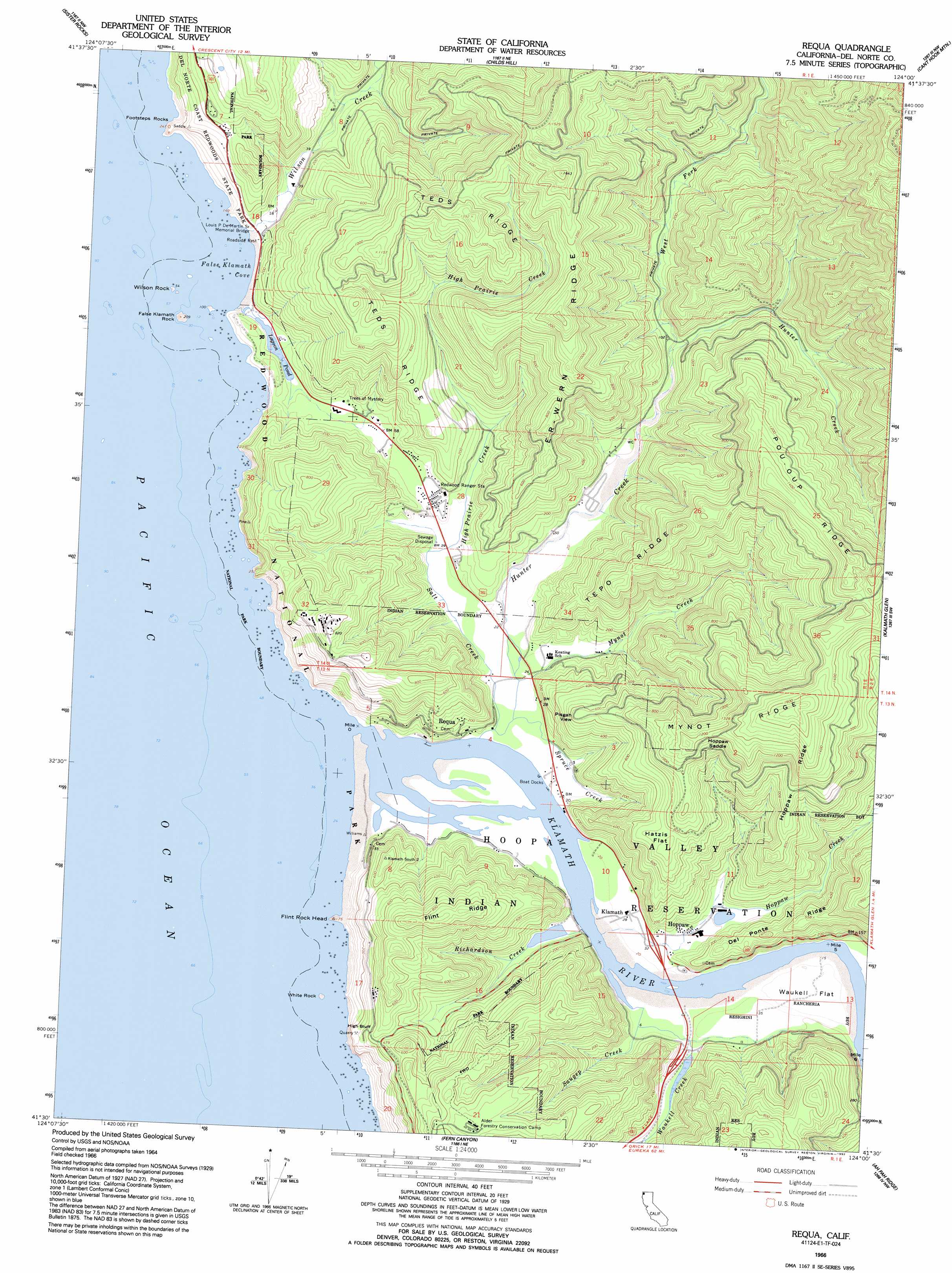
Requa Topo Map California
To zoom in, hover over the map of Requa
USGS Topo Quad 41124e1 - 1:24,000 scale
| Topo Map Name: | Requa |
| USGS Topo Quad ID: | 41124e1 |
| Print Size: | ca. 21 1/4" wide x 27" high |
| Southeast Coordinates: | 41.5° N latitude / 124° W longitude |
| Map Center Coordinates: | 41.5625° N latitude / 124.0625° W longitude |
| U.S. State: | CA |
| Filename: | o41124e1.jpg |
| Download Map JPG Image: | Requa topo map 1:24,000 scale |
| Map Type: | Topographic |
| Topo Series: | 7.5´ |
| Map Scale: | 1:24,000 |
| Source of Map Images: | United States Geological Survey (USGS) |
| Alternate Map Versions: |
Requa CA 1966, updated 1968 Download PDF Buy paper map Requa CA 1966, updated 1992 Download PDF Buy paper map Requa CA 1997, updated 2001 Download PDF Buy paper map Requa CA 2012 Download PDF Buy paper map Requa CA 2015 Download PDF Buy paper map |
| FStopo: | US Forest Service topo Requa is available: Download FStopo PDF Download FStopo TIF |
1:24,000 Topo Quads surrounding Requa
Crescent City |
Hiouchi |
Gasquet |
Hurdygurdy Butte |
|
Sister Rocks |
Childs Hill |
Cant Hook Mountain |
Ship Mountain |
|
Requa |
Klamath Glen |
Summit Valley |
||
Fern Canyon |
Ah Pah Ridge |
Blue Creek Mountain |
||
Orick |
Holter Ridge |
Johnsons |
> Back to 41124e1 at 1:100,000 scale
> Back to 41124a1 at 1:250,000 scale
> Back to U.S. Topo Maps home
Requa topo map: Gazetteer
Requa: Airports
Del Norte County Landing Strip elevation 8m 26′Requa: Bays
False Klamath Cove elevation 0m 0′Requa: Beaches
Wilson Creek Beach elevation 11m 36′Requa: Bridges
Douglas Memorial Bridge (historical) elevation 2m 6′Louis P DeMartin Senior Memorial Bridge elevation 15m 49′
Requa: Cliffs
High Bluff elevation 58m 190′Requa: Flats
Hatzis Flat elevation 235m 770′Waukell Flat elevation 9m 29′
Requa: Forests
Yurok Redwood Experimental Forest elevation 323m 1059′Requa: Gaps
Hoppaw Saddle elevation 369m 1210′Requa: Islands
False Klamath Rock elevation 20m 65′Safford Island (historical) elevation -2m -7′
White Rock elevation 19m 62′
Wilson Rock elevation 0m 0′
Requa: Lakes
Lagoon Pond elevation 8m 26′Requa: Populated Places
Camp Klamath elevation 8m 26′False Klamath elevation 11m 36′
Hoppaw elevation 11m 36′
Khwunrghunme (historical) elevation 10m 32′
Klamath elevation 9m 29′
Rekwoi (historical) elevation 3m 9′
Requa elevation 38m 124′
Waukell Flat (historical) elevation 7m 22′
Requa: Ridges
Del Ponte Ridge elevation 104m 341′Er-Wern Ridge elevation 357m 1171′
Flint Ridge elevation 269m 882′
Hoppaw Ridge elevation 317m 1040′
Mynot Ridge elevation 430m 1410′
Pou-Oup Ridge elevation 468m 1535′
Teds Ridge elevation 346m 1135′
Tepo Ridge elevation 272m 892′
Requa: Streams
High Prairie Creek elevation 6m 19′Hoppaw Creek elevation 2m 6′
Hunter Creek elevation 4m 13′
Klamath River elevation 0m 0′
Klamath River elevation 0m 0′
Mynot Creek elevation 6m 19′
Richardson Creek elevation 8m 26′
Salt Creek elevation 1m 3′
Saugep Creek elevation 6m 19′
Spruce Creek elevation 5m 16′
Turwar Creek elevation 6m 19′
Waukell Creek elevation 7m 22′
West Fork Hunter Creek elevation 24m 78′
Wilson Creek elevation 11m 36′
Requa: Summits
Flint Rock Head elevation 32m 104′Footsteps Rocks elevation 60m 196′
Requa: Woods
Trees of Mystery elevation 24m 78′Requa digital topo map on disk
Buy this Requa topo map showing relief, roads, GPS coordinates and other geographical features, as a high-resolution digital map file on DVD: