Crescent City Topo Map California
To zoom in, hover over the map of Crescent City
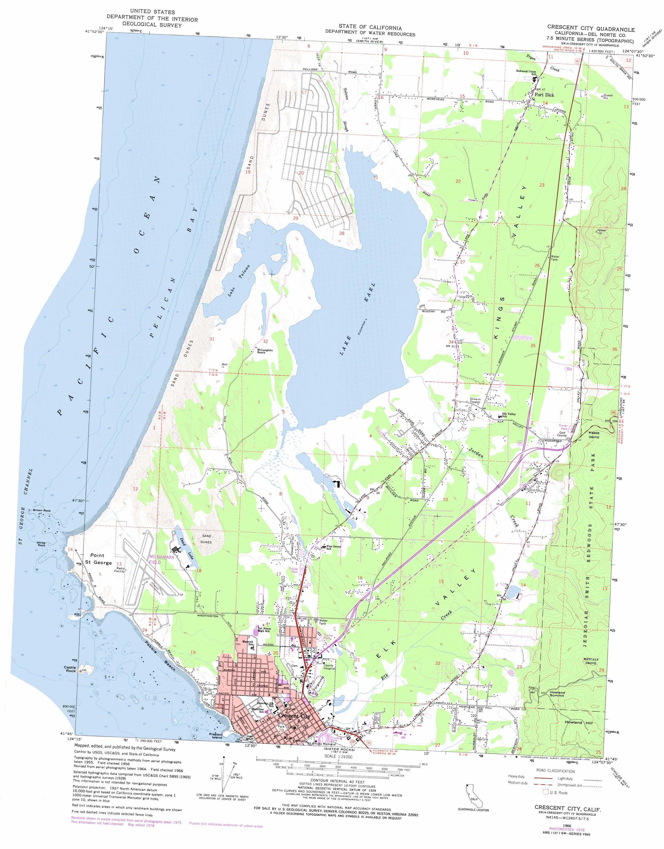
USGS Topo Quad 41124g2 - 1:24,000 scale
| Topo Map Name: | Crescent City |
| USGS Topo Quad ID: | 41124g2 |
| Print Size: | ca. 21 1/4" wide x 27" high |
| Southeast Coordinates: | 41.75° N latitude / 124.125° W longitude |
| Map Center Coordinates: | 41.8125° N latitude / 124.1875° W longitude |
| U.S. State: | CA |
| Filename: | o41124g2.jpg |
| Download Map JPG Image: | Crescent City topo map 1:24,000 scale |
| Map Type: | Topographic |
| Topo Series: | 7.5´ |
| Map Scale: | 1:24,000 |
| Source of Map Images: | United States Geological Survey (USGS) |
| Alternate Map Versions: |
Crescent City CA 1956, updated 1957 Download PDF Buy paper map Crescent City CA 1956, updated 1957 Download PDF Buy paper map Crescent City CA 1966, updated 1968 Download PDF Buy paper map Crescent City CA 1966, updated 1968 Download PDF Buy paper map Crescent City CA 1966, updated 1974 Download PDF Buy paper map Crescent City CA 1966, updated 1974 Download PDF Buy paper map Crescent City CA 1966, updated 1978 Download PDF Buy paper map Crescent City CA 1966, updated 1978 Download PDF Buy paper map Crescent City CA 2012 Download PDF Buy paper map Crescent City CA 2015 Download PDF Buy paper map |
1:24,000 Topo Quads surrounding Crescent City
Brookings |
Mount Emily |
Fourth Of July Creek |
Biscuit Hill |
|
Smith River |
High Divide |
High Plateau Mountain |
||
Crescent City |
Hiouchi |
Gasquet |
||
Sister Rocks |
Childs Hill |
Cant Hook Mountain |
||
Requa |
Klamath Glen |
> Back to 41124e1 at 1:100,000 scale
> Back to 41124a1 at 1:250,000 scale
> Back to U.S. Topo Maps home
Crescent City topo map: Gazetteer
Crescent City: Airports
Jack McNamara Field elevation 17m 55′McNamara Field elevation 17m 55′
Crescent City: Bays
Pelican Bay elevation 0m 0′Crescent City: Beaches
Kellogg Road Beach elevation 1m 3′Pebble Beach elevation 1m 3′
Crescent City: Cliffs
Half Butte elevation 11m 36′Crescent City: Islands
Castle Rock elevation 36m 118′Preston Island elevation 4m 13′
Crescent City: Lakes
Dead Lake elevation 11m 36′Lake Earl elevation 2m 6′
Lake Talawa elevation 2m 6′
Crescent City: Parks
Brother Jonathan Park elevation 16m 52′Castle Rock National Wildlife Refuge elevation 27m 88′
Del Norte County Fairgrounds elevation 6m 19′
S S Emido Memorial elevation 3m 9′
Tolowa Dunes State Park elevation 18m 59′
Crescent City: Populated Places
Crescent City elevation 13m 42′Fort Dick elevation 16m 52′
Pacific Shores elevation 6m 19′
Tatlatunne (historical) elevation 0m 0′
Crescent City: Post Offices
Crescent City Post Office elevation 6m 19′Crescent City: Streams
Elk Creek elevation 3m 9′Jordan Creek elevation 2m 6′
Marhoffer Creek elevation 2m 6′
Talawa Slough elevation 3m 9′
Crescent City: Summits
Howland Hill elevation 222m 728′Howland Summit elevation 175m 574′
Crescent City: Valleys
Elk Valley elevation 3m 9′Kings Valley elevation 9m 29′
Crescent City: Woods
Metcalf Grove elevation 117m 383′Weber Grove elevation 125m 410′
Crescent City digital topo map on disk
Buy this Crescent City topo map showing relief, roads, GPS coordinates and other geographical features, as a high-resolution digital map file on DVD: