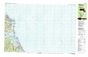
Scituate Topo Map Massachusetts
To zoom in, hover over the map of Scituate
USGS Topo Quad 42070b5 - 1:25,000 scale
| Topo Map Name: | Scituate |
| USGS Topo Quad ID: | 42070b5 |
| Print Size: | ca. 39" wide x 24" high |
| Southeast Coordinates: | 42.125° N latitude / 70.5° W longitude |
| Map Center Coordinates: | 42.1875° N latitude / 70.625° W longitude |
| U.S. State: | MA |
| Filename: | k42070b5.jpg |
| Download Map JPG Image: | Scituate topo map 1:25,000 scale |
| Map Type: | Topographic |
| Topo Series: | 7.5´x15´ |
| Map Scale: | 1:25,000 |
| Source of Map Images: | United States Geological Survey (USGS) |
| Alternate Map Versions: |
Scituate MA 1984, updated 1984 Download PDF Buy paper map Scituate MA 1984, updated 1984 Download PDF Buy paper map |
1:24,000 Topo Quads surrounding Scituate
Marblehead South |
||||
Nantasket Beach |
||||
Cohasset |
Scituate |
|||
Hanover |
Duxbury |
|||
Plympton |
Plymouth |
Manomet |
> Back to 42070a1 at 1:100,000 scale
> Back to 42070a1 at 1:250,000 scale
> Back to U.S. Topo Maps home
Scituate topo map: Gazetteer
Scituate: Bars
Collamore Ledge elevation 0m 0′Cowen Rocks elevation 0m 0′
Long Ledge elevation 0m 0′
Long Ledge elevation 0m 0′
No Mans Ledge elevation 0m 0′
Sunken Ledge elevation 0m 0′
Scituate: Bays
Herring River elevation 1m 3′Scituate: Beaches
Humarock Beach elevation 3m 9′Peggotty Beach elevation 1m 3′
Scituate: Capes
Cedar Point elevation 3m 9′Scituate: Cliffs
First Cliff elevation 1m 3′Fourth Cliff elevation 0m 0′
Second Cliff elevation 8m 26′
Third Cliff elevation 15m 49′
Scituate: Dams
Damon Point Road Dam elevation 2m 6′Old Oaken Bucket Pond Dam elevation 5m 16′
Scituate: Guts
New Inlet elevation 2m 6′Scituate: Harbors
Scituate Harbor elevation 0m 0′Scituate: Islands
Bartletts Island elevation 4m 13′Bear Island elevation 3m 9′
Macombers Island elevation 3m 9′
Old Sow elevation 0m 0′
Tar Pouch elevation 0m 0′
Tilden Island elevation 15m 49′
Trouant Island elevation 7m 22′
Wills Island elevation 3m 9′
Wood Island elevation 3m 9′
Scituate: Lakes
Lewis Pond elevation 7m 22′Sheep Ponds elevation 3m 9′
Wales Pond elevation 25m 82′
Scituate: Parks
Cushing Memorial State Park elevation 14m 45′Scituate: Populated Places
Egypt Beach elevation 0m 0′Ferry Hill elevation 21m 68′
First Cliff elevation 6m 19′
Fourth Cliff elevation 3m 9′
Greenbush elevation 5m 16′
Hatherly Beach elevation 1m 3′
Humarock elevation 3m 9′
Little Bridge elevation 7m 22′
Mann Hill Beach elevation 3m 9′
Marshfield Hills elevation 39m 127′
Old Mouth North River elevation 0m 0′
Rivermoor elevation 14m 45′
Sand Hills elevation 7m 22′
Scituate elevation 11m 36′
Scituate Station elevation 11m 36′
Sea View elevation 9m 29′
Second Cliff elevation 17m 55′
Shore Acres elevation 8m 26′
Third Cliff elevation 19m 62′
Scituate: Post Offices
Greenbush Post Office (historical) elevation 9m 29′Marshfield Hills Post Office (historical) elevation 36m 118′
Scituate Post Office (historical) elevation 1m 3′
Sea View Post Office (historical) elevation 9m 29′
Scituate: Ridges
Crow Point elevation 3m 9′Scituate: Streams
Bares Brook elevation 2m 6′Branch Creek elevation 2m 6′
Broad Creek elevation 2m 6′
First Herring Brook elevation 2m 6′
Hannah Eames Brook elevation 2m 6′
Littles Creek elevation 3m 9′
Macombers Creek elevation 3m 9′
North River elevation 3m 9′
Satuit Brook elevation 3m 9′
South River elevation 3m 9′
Scituate: Summits
Brushy Hill elevation 27m 88′Carolina Hill elevation 77m 252′
Coleman Hills elevation 5m 16′
Ferry Hill elevation 21m 68′
Hagar Hill elevation 56m 183′
Holly Hill elevation 46m 150′
Scituate: Swamps
North River Marsh elevation 2m 6′North River Marshes elevation 3m 9′
Scituate Harbor Marshes elevation 3m 9′
Scituate digital topo map on disk
Buy this Scituate topo map showing relief, roads, GPS coordinates and other geographical features, as a high-resolution digital map file on DVD:
Maine, New Hampshire, Rhode Island & Eastern Massachusetts
Buy digital topo maps: Maine, New Hampshire, Rhode Island & Eastern Massachusetts


