Nantasket Beach Topo Map Massachusetts
To zoom in, hover over the map of Nantasket Beach
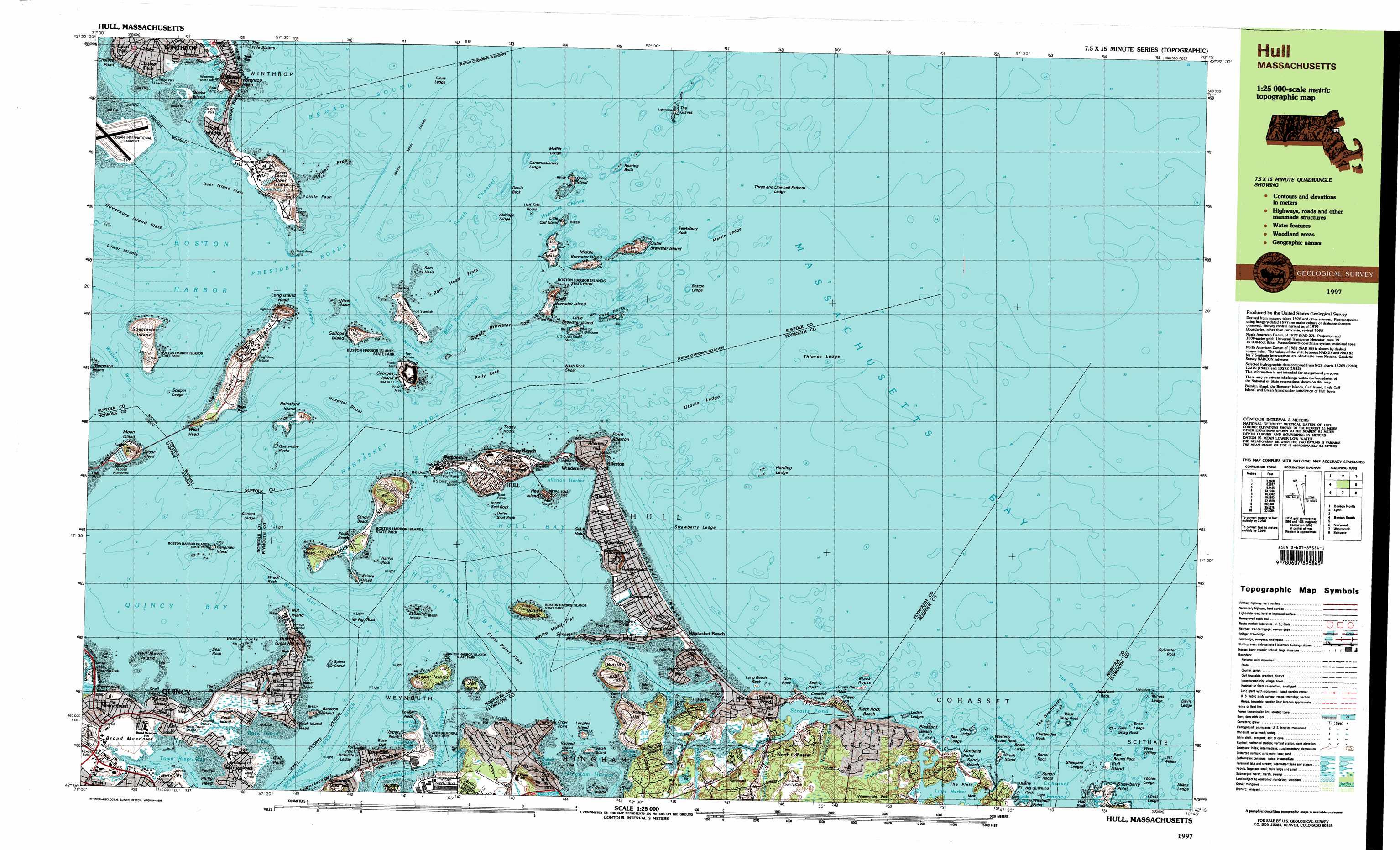
USGS Topo Quad 42070c7 - 1:25,000 scale
| Topo Map Name: | Nantasket Beach |
| USGS Topo Quad ID: | 42070c7 |
| Print Size: | ca. 39" wide x 24" high |
| Southeast Coordinates: | 42.25° N latitude / 70.75° W longitude |
| Map Center Coordinates: | 42.3125° N latitude / 70.875° W longitude |
| U.S. State: | MA |
| Filename: | k42070c7.jpg |
| Download Map JPG Image: | Nantasket Beach topo map 1:25,000 scale |
| Map Type: | Topographic |
| Topo Series: | 7.5´x15´ |
| Map Scale: | 1:25,000 |
| Source of Map Images: | United States Geological Survey (USGS) |
| Alternate Map Versions: |
Hull MA 1984, updated 1984 Download PDF Buy paper map Hull MA 1997, updated 1999 Download PDF Buy paper map |
1:24,000 Topo Quads surrounding Nantasket Beach
Reading |
Salem |
Gloucester |
||
Boston North |
Marblehead South |
|||
Boston South |
Nantasket Beach |
|||
Blue Hills |
Cohasset |
Scituate |
||
Brockton |
Whitman |
Hanover |
Duxbury |
> Back to 42070a1 at 1:100,000 scale
> Back to 42070a1 at 1:250,000 scale
> Back to U.S. Topo Maps home
Nantasket Beach topo map: Gazetteer
Nantasket Beach: Airports
Pleasant Beach Heliport elevation 0m 0′Nantasket Beach: Bars
Black Ledge elevation 0m 0′Black Rocks elevation 0m 0′
Boston Ledge elevation 0m 0′
Brush Ledge elevation 0m 0′
Bumkin Island elevation 0m 0′
Chest Ledge elevation 0m 0′
Cohasset Rocks elevation 0m 0′
Crow Point Flats elevation 0m 0′
Davis Ledge elevation 0m 0′
Devils Back elevation 0m 0′
East Willies elevation 0m 0′
Enos Ledge elevation 0m 0′
False Spit elevation 0m 0′
Great Faun elevation 0m 0′
Halftide Rocks elevation 0m 0′
Harding Ledge elevation 0m 0′
Hospital Shoal elevation 0m 0′
Inner Minot elevation 0m 0′
Little Black Rock elevation 0m 0′
Little Faun elevation 0m 0′
Lower Middle elevation 0m 0′
Martin Ledge elevation 0m 0′
Mikes Ledge elevation 0m 0′
Minots Ledge elevation 0m 0′
Nash Rock Shoal elevation 0m 0′
Nixes Mate elevation 0m 0′
Outer Minot elevation 0m 0′
Quarantine Rocks elevation 0m 0′
Quarter Ledge elevation 13m 42′
Ram Head elevation 0m 0′
Roaring Bulls elevation 0m 0′
Sea Ledge elevation 0m 0′
Seal Rock elevation 3m 9′
Shag Rocks elevation 0m 0′
Sheppard Ledges elevation 0m 0′
Strawberry Ledge elevation 0m 0′
Sunken Ledge elevation 0m 0′
Sutton Rocks elevation 0m 0′
The Grampuses elevation 0m 0′
Thieves Ledge elevation 0m 0′
Three and One-half Fathom Ledge elevation 0m 0′
Toddy Rocks elevation 0m 0′
Ultonia Ledge elevation 0m 0′
Utonia Ledge elevation 0m 0′
Veazie Rocks elevation 0m 0′
Nantasket Beach: Bays
Blacks Creek elevation 0m 0′Boston Harbor elevation 0m 0′
Cohasset Harbor elevation 0m 0′
Crystal Cove elevation 4m 13′
Hewitts Cove elevation 0m 0′
Hingham Bay elevation 0m 0′
Hull Bay elevation 0m 0′
Lower Neck Cove elevation 0m 0′
Martins Well elevation 1m 3′
Perry Cove elevation 0m 0′
Portuguese Cove elevation 0m 0′
Quincy Bay elevation 0m 0′
Rock Island Cove elevation 0m 0′
Sandy Cove elevation 1m 3′
Town River elevation 0m 0′
Upper Neck Cove elevation -1m -4′
Walton Cove elevation 0m 0′
Weymouth Back River elevation 0m 0′
Weymouth Fore River elevation 0m 0′
Nantasket Beach: Beaches
Black Rock Beach elevation 2m 6′Crescent Beach elevation 0m 0′
Manet Beach elevation 0m 0′
Nantasket Beach elevation 0m 0′
Pleasant Beach elevation 1m 3′
Sandy Beach elevation 0m 0′
Yirrell Beach elevation 0m 0′
Nantasket Beach: Benches
Graves Ledge elevation 0m 0′Nantasket Beach: Capes
Bass Point elevation 0m 0′Chelsea Point elevation 10m 32′
Crow Point elevation 0m 0′
Deer Island elevation 12m 39′
Eastern Neck elevation 3m 9′
Fort Point elevation 3m 9′
Gull Point elevation 2m 6′
Hole Point elevation 1m 3′
Houghs Neck elevation 7m 22′
Kimballs Point elevation 2m 6′
Lower Neck elevation 1m 3′
Philip Head elevation 0m 0′
Point Allerton elevation 8m 26′
Point Shirley elevation 3m 9′
Quarry Point elevation 0m 0′
Rock Island Head elevation 0m 0′
Rocky Neck elevation 0m 0′
Scituate Neck elevation 8m 26′
Strawberry Point elevation 0m 0′
Sunset Point elevation 0m 0′
Upper Neck elevation 8m 26′
Windmill Point elevation 0m 0′
Windmill Point elevation 3m 9′
Nantasket Beach: Channels
Boston North Channel elevation 0m 0′Boston South Channel elevation 0m 0′
Governors Channel (historical) elevation 0m 0′
Hypocrite Channel elevation 0m 0′
Nantasket Roads elevation 0m 0′
Nubble Channel elevation 0m 0′
President Roads elevation 0m 0′
Sculpin Ledge Channel elevation 0m 0′
The Gangway elevation 0m 0′
The Narrows elevation 0m 0′
Nantasket Beach: Cliffs
East Head elevation 3m 9′Long Island Head elevation 26m 85′
Middle Head elevation 1m 3′
Moon Head elevation 12m 39′
Nut Island elevation 3m 9′
Quincy Great Hill elevation 28m 91′
Rose Cliff elevation 1m 3′
West Head elevation 16m 52′
Winthrop Head elevation 25m 82′
Worlds End elevation 11m 36′
Nantasket Beach: Dams
Nichols Road Dam elevation 13m 42′Straits Pond Dam elevation 2m 6′
Nantasket Beach: Flats
Broad Meadows elevation 4m 13′Deer Island Flats elevation 0m 0′
Governors Island Flats elevation 0m 0′
Great Brewster Spit elevation 0m 0′
Ram Head Flats elevation 0m 0′
The Flats elevation 1m 3′
White Head Flats elevation 0m 0′
Nantasket Beach: Guts
Black Rock Channel elevation 0m 0′Eastern Channel elevation 0m 0′
Hull Gut elevation 0m 0′
West Gut elevation 0m 0′
Western Channel elevation 0m 0′
Western Way elevation 0m 0′
Nantasket Beach: Harbors
Allerton Harbor elevation 0m 0′Hingham Harbor elevation 0m 0′
Little Harbor elevation 0m 0′
Sailors Snug Harbor elevation 1m 3′
Nantasket Beach: Islands
Aldridge Ledge elevation 0m 0′Apple Island elevation 2m 6′
Barrel Rock elevation 0m 0′
Bass Rock elevation 0m 0′
Big Quamino Rock elevation 0m 0′
Black Rock elevation 0m 0′
Brewster Islands elevation 0m 0′
Brush Island elevation 0m 0′
Buckthorn Rock elevation 0m 0′
Bumkin Island elevation 20m 65′
Button Island elevation 0m 0′
Calf Island elevation 2m 6′
Calf Islands elevation 0m 0′
Cat Island elevation 0m 0′
Chittenden Rock elevation 0m 0′
Commissioners Ledge elevation 0m 0′
East Hogshead Rock elevation 0m 0′
East Round Rock elevation 0m 0′
East Shag Rock elevation 0m 0′
Finns Ledge elevation 0m 0′
Flying Place elevation 0m 0′
Gallops Island elevation 18m 59′
Georges Island elevation 0m 0′
Grape Island elevation 6m 19′
Great Brewster Island elevation 6m 19′
Green Hill Rock elevation 0m 0′
Green Island elevation 1m 3′
Gull Island elevation 0m 0′
Gun Rock elevation 0m 0′
Half Moon Island elevation 0m 0′
Half Moon Island (historical) elevation 3m 9′
Hangman Island elevation 1m 3′
Harrys Rock elevation 1m 3′
Hog Rock elevation 0m 0′
Hogshead Rock elevation 0m 0′
Hunt Ledge elevation 0m 0′
Inner Seal Rock elevation 0m 0′
Jack Rock elevation 0m 0′
Jacknife Ledge elevation 0m 0′
Kelly Rock elevation 0m 0′
Langlee Island elevation 5m 16′
Little Brewster Island elevation 8m 26′
Little Calf Island elevation 0m 0′
Little Quamino Rock elevation 0m 0′
Long Beach Rock elevation 0m 0′
Long Island elevation 20m 65′
Lovell Island elevation 6m 19′
Maffitt Ledge elevation 0m 0′
Middle Brewster Island elevation 2m 6′
Mink Island elevation 1m 3′
Moon Island elevation 13m 42′
Northeast Grave elevation 0m 0′
Outer Brewster Island elevation 16m 52′
Outer Seal Rock elevation 0m 0′
Peddocks Island elevation 7m 22′
Pig Rock elevation 0m 0′
Pope Rock elevation 0m 0′
Raccoon Island elevation 5m 16′
Ragged Island elevation 0m 0′
Rainsford Island elevation 16m 52′
Sarah Island elevation 0m 0′
Sculpin Ledge elevation 0m 0′
Seal Rock elevation 0m 0′
Seal Rock elevation 0m 0′
Sheep Island elevation 0m 0′
Slate Island elevation 5m 16′
Snake Island elevation 1m 3′
Spectacle Island elevation 15m 49′
Spiers Stand elevation 0m 0′
Spinnaker Island elevation 0m 0′
Sylvester Rock elevation 0m 0′
Tewksbury Rock elevation 0m 0′
The Graves elevation 0m 0′
The Piglets elevation 0m 0′
Tobias Ledge elevation 0m 0′
West Hogshead Rock elevation 0m 0′
West Shag Rock elevation 0m 0′
West Willies elevation 0m 0′
Westerly Round Rock elevation 0m 0′
Whitings Ledge elevation 0m 0′
Wreck Rock elevation 0m 0′
Nantasket Beach: Isthmuses
Prince Head elevation 3m 9′Nantasket Beach: Lakes
Broad Cove elevation 4m 13′Lewis Lake elevation 1m 3′
Nantasket Beach: Parks
Boston Harbor Island State Park elevation 11m 36′Great Hill Park elevation 41m 134′
Hawthorne Gardens elevation 4m 13′
Monument Square elevation 3m 9′
Paragon Park elevation 0m 0′
William K Webb Park elevation 11m 36′
Nantasket Beach: Pillars
Pulpit Rock elevation 0m 0′Nantasket Beach: Populated Places
Adams Shore elevation 1m 3′Allerton elevation 5m 16′
Atlantic elevation 25m 82′
Bayside elevation 3m 9′
Cottage Hill elevation 27m 88′
Cottage Park elevation 5m 16′
Court Park elevation 11m 36′
Crow Point elevation 21m 68′
Fort Andrews elevation 4m 13′
Fort Dawes elevation 24m 78′
Fort Duvall elevation 17m 55′
Fort Revere elevation 18m 59′
Fort Warren elevation 14m 45′
Germantown elevation 5m 16′
Houghs Neck elevation 7m 22′
Hull elevation 17m 55′
Kenberma elevation 3m 9′
Merrymount elevation 8m 26′
Nantasket Beach elevation 5m 16′
North Cohasset elevation 21m 68′
Pemberton elevation 2m 6′
Point Shirley elevation 3m 9′
Post Island elevation 3m 9′
Rock Island elevation 3m 9′
Stony Beach elevation 0m 0′
Straits Pond elevation 8m 26′
Waveland elevation 3m 9′
Windemere elevation 13m 42′
Nantasket Beach: Post Offices
Hull Post Office (historical) elevation 2m 6′Nantasket Post Office (historical) elevation 3m 9′
Nantasket Beach: Reservoirs
Little Harbor Reservoir elevation 13m 42′Straits Pond elevation 2m 6′
Nantasket Beach: Streams
Rattlesnake Run elevation 2m 6′Richardsons Brook elevation 1m 3′
Town Brook elevation 6m 19′
Turkey Hill Run elevation 0m 0′
Weir River elevation 0m 0′
Weymouth Back River elevation 0m 0′
Nantasket Beach: Summits
Allerton Hill elevation 37m 121′Atlantic Hill elevation 25m 82′
Center Hill elevation 21m 68′
Cottage Hill elevation 27m 88′
Green Hill elevation 7m 22′
Hampton Hill elevation 10m 32′
Otis Hill elevation 40m 131′
Planters Hill elevation 36m 118′
Sagamore Hill elevation 25m 82′
Strawberry Hill elevation 30m 98′
Telegraph Hill elevation 37m 121′
White Head elevation 13m 42′
Nantasket Beach: Swamps
Rock Island Cove Marshes elevation 2m 6′The Glades elevation 2m 6′
Town River Marshes elevation 6m 19′
Nantasket Beach digital topo map on disk
Buy this Nantasket Beach topo map showing relief, roads, GPS coordinates and other geographical features, as a high-resolution digital map file on DVD:
Maine, New Hampshire, Rhode Island & Eastern Massachusetts
Buy digital topo maps: Maine, New Hampshire, Rhode Island & Eastern Massachusetts