Rockport Topo Map Massachusetts
To zoom in, hover over the map of Rockport
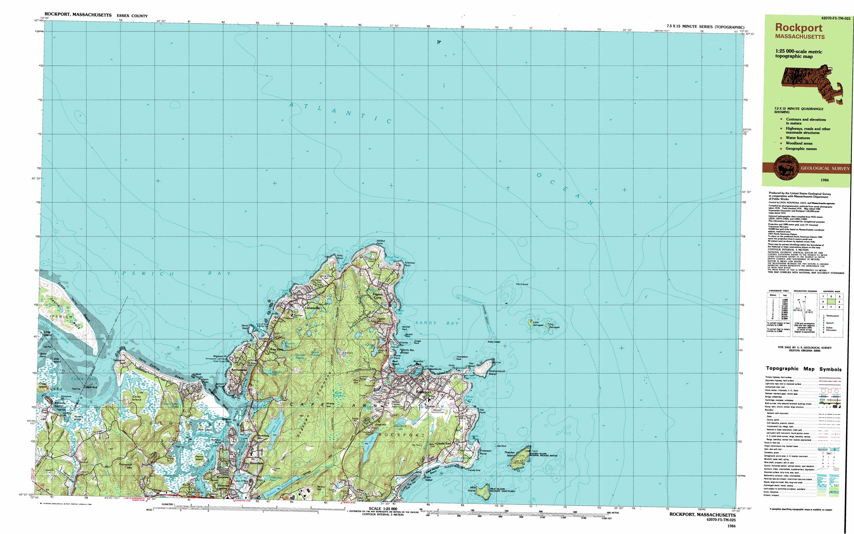
USGS Topo Quad 42070f5 - 1:25,000 scale
| Topo Map Name: | Rockport |
| USGS Topo Quad ID: | 42070f5 |
| Print Size: | ca. 39" wide x 24" high |
| Southeast Coordinates: | 42.625° N latitude / 70.5° W longitude |
| Map Center Coordinates: | 42.6875° N latitude / 70.625° W longitude |
| U.S. State: | MA |
| Filename: | k42070f5.jpg |
| Download Map JPG Image: | Rockport topo map 1:25,000 scale |
| Map Type: | Topographic |
| Topo Series: | 7.5´x15´ |
| Map Scale: | 1:25,000 |
| Source of Map Images: | United States Geological Survey (USGS) |
| Alternate Map Versions: |
Rockport MA 1984, updated 1984 Download PDF Buy paper map Rockport MA 1984, updated 1984 Download PDF Buy paper map |
1:24,000 Topo Quads surrounding Rockport
Hampton |
Isles of Shoals |
|||
Newburyport East |
||||
Ipswich |
Rockport |
|||
Salem |
Gloucester |
|||
Marblehead South |
> Back to 42070e1 at 1:100,000 scale
> Back to 42070a1 at 1:250,000 scale
> Back to U.S. Topo Maps home
Rockport topo map: Gazetteer
Rockport: Airports
Nugent Heliport elevation 17m 55′Pond Road Heliport elevation 20m 65′
Pooles Heliport elevation 14m 45′
Rockport: Bars
Avery Ledge elevation 0m 0′Bald Rocks elevation 0m 0′
Barn Rocks elevation 0m 0′
Flat Ground elevation 0m 0′
Little Salvages elevation 0m 0′
Milk Island Bar elevation 0m 0′
The Salvages elevation 0m 0′
Rockport: Basins
Bay State Quarry elevation 32m 104′Gannerys Quarry elevation 27m 88′
Rockport: Bays
Annisquam Harbor elevation 0m 0′Essex Bay elevation 0m 0′
Folly Cove elevation 0m 0′
Gap Cove elevation 6m 19′
Goose Cove elevation 0m 0′
Gull Cove elevation 0m 0′
Gully Point Cove elevation 0m 0′
Hodgkins Cove elevation 0m 0′
Hoop Pole Cove elevation 0m 0′
Ipswich Bay elevation 0m 0′
Lanes Cove elevation 1m 3′
Loblolly Cove elevation 0m 0′
Lobster Cove elevation 0m 0′
Pigeon Cove elevation 1m 3′
Plum Cove elevation 2m 6′
Sandy Bay elevation 0m 0′
Whale Cove elevation 3m 9′
Rockport: Beaches
Cape Hedge Beach elevation 10m 32′Coffins Beach elevation 3m 9′
Front Beach elevation 3m 9′
Long Beach elevation 0m 0′
Old Garden Beach elevation 9m 29′
Pebbly Beach elevation 6m 19′
Wingaersheek Beach elevation 2m 6′
Rockport: Capes
Andrews Point elevation 5m 16′Babson Point elevation 0m 0′
Bearskin Neck elevation 3m 9′
Bearskin Neck elevation 3m 9′
Cape Ann elevation 12m 39′
Cape Hedge elevation 1m 3′
Coles Island elevation 8m 26′
Conomo Point elevation 7m 22′
Davis Neck elevation 2m 6′
Emerson Point elevation 5m 16′
Farm Point elevation 3m 9′
Flat Point elevation 7m 22′
Folly Point elevation 3m 9′
Gap Head elevation 0m 0′
Gully Point elevation 0m 0′
Halibut Point elevation 7m 22′
Lands End elevation 6m 19′
Loblolly Point elevation 1m 3′
Rowe Point elevation 0m 0′
Rust Island elevation 18m 59′
Thurston Point elevation 7m 22′
Twopenny Loaf elevation 4m 13′
Wheeler Point elevation 4m 13′
Wigwam Point elevation 2m 6′
Rockport: Channels
Choate Island Channel elevation 0m 0′North Channel elevation 18m 59′
Rockport: Cliffs
Brier Neck elevation 9m 29′The Headlands elevation 5m 16′
Rockport: Crossings
Interchange Twelve elevation 43m 141′Rockport: Dams
Babson Reservoir Dam elevation 16m 52′Goose Cove North Dam elevation 23m 75′
Goose Cove Northwest Dike elevation 26m 85′
Goose Cove South Dam elevation 27m 88′
Goose Cove Southwest Dike elevation 27m 88′
Mill River Culvert and Tide Gate Dam elevation 2m 6′
Quarry Reservoir Dam elevation 15m 49′
Strangman Pond Dam elevation 32m 104′
Rockport: Flats
Wings Flats elevation 0m 0′Rockport: Guts
Annisquam River elevation 0m 0′Rockport: Harbors
Back Harbor elevation 0m 0′Rockport Harbor elevation 9m 29′
Rockport: Islands
Bartlett Rock elevation 0m 0′Black Rock elevation 2m 6′
Boynton Island elevation 8m 26′
Dilly Island elevation 2m 6′
Dodge Rock elevation 0m 0′
Dry Salvages elevation 1m 3′
Harbor Rock elevation 0m 0′
High Rock elevation 33m 108′
Londoner elevation 0m 0′
Milk Island elevation 4m 13′
Mitchell Rock elevation 0m 0′
Oak Island elevation 4m 13′
Oak Rock elevation 0m 0′
Pearce Island elevation 10m 32′
Pigeon Rock elevation 0m 0′
Ram Island elevation 1m 3′
Sandy Bay Ledge elevation 0m 0′
Straitsmouth Island elevation 9m 29′
Thacher Island elevation 2m 6′
Tommy Island elevation 1m 3′
Twelvefoot Rock elevation 0m 0′
Rockport: Lakes
Camborne Pond elevation 4m 13′Cape Pond elevation 24m 78′
Langsford Pond elevation 10m 32′
Loop Pond elevation 23m 75′
Rum Rock Lake elevation 25m 82′
Sleepy Hollow Pond elevation 2m 6′
Rockport: Parks
Evans Field elevation 49m 160′Halibut Point Reservation elevation 4m 13′
Rockport: Populated Places
Annisquam elevation 21m 68′Bay View elevation 21m 68′
Dogtown Commons elevation 24m 78′
Eden Square elevation 15m 49′
Lands End elevation 25m 82′
Lanesville elevation 10m 32′
Ocean View elevation 23m 75′
Pigeon Cove elevation 35m 114′
Riverdale elevation 25m 82′
Riverdale Station elevation 10m 32′
Riverview elevation 13m 42′
Riverview Landing elevation 0m 0′
Rockport elevation 16m 52′
Rowley Shore elevation 17m 55′
Stonehaven (historical) elevation 10m 32′
Wingaersheek (historical) elevation 18m 59′
Rockport: Reservoirs
Babson Reservoir elevation 16m 52′Mill Pond elevation 2m 6′
Strangman Pond elevation 32m 104′
Rockport: Streams
Alewife Brook elevation 14m 45′Annisquam River elevation 0m 0′
Castle Neck River elevation 2m 6′
Essex River elevation 0m 0′
Farm Creek elevation 2m 6′
Jones River elevation 3m 9′
Lanes Creek elevation 2m 6′
Mill Brook elevation 0m 0′
Mill River elevation 0m 0′
Sawmill Brook elevation 0m 0′
Walker Creek elevation 5m 16′
Rockport: Summits
Cross Island elevation 22m 72′Ferry Hill elevation 15m 49′
Great Hill elevation 51m 167′
Pigeon Hill elevation 61m 200′
Pool Hill elevation 66m 216′
Railcut Hill elevation 56m 183′
Sunset Hill elevation 32m 104′
Thompson Mountain elevation 47m 154′
Twopenny Loaf elevation 13m 42′
Rockport: Swamps
Annisquam River Marshes elevation 1m 3′Briar Swamp elevation 47m 154′
Essex Bay Marshes elevation 2m 6′
Farm Creek Marshes elevation 2m 6′
Jones River Marshes elevation 1m 3′
Mill Pond Marshes elevation 4m 13′
Walker Creek Marshes elevation 3m 9′
Rockport digital topo map on disk
Buy this Rockport topo map showing relief, roads, GPS coordinates and other geographical features, as a high-resolution digital map file on DVD:
Maine, New Hampshire, Rhode Island & Eastern Massachusetts
Buy digital topo maps: Maine, New Hampshire, Rhode Island & Eastern Massachusetts