Medfield Topo Map Massachusetts
To zoom in, hover over the map of Medfield
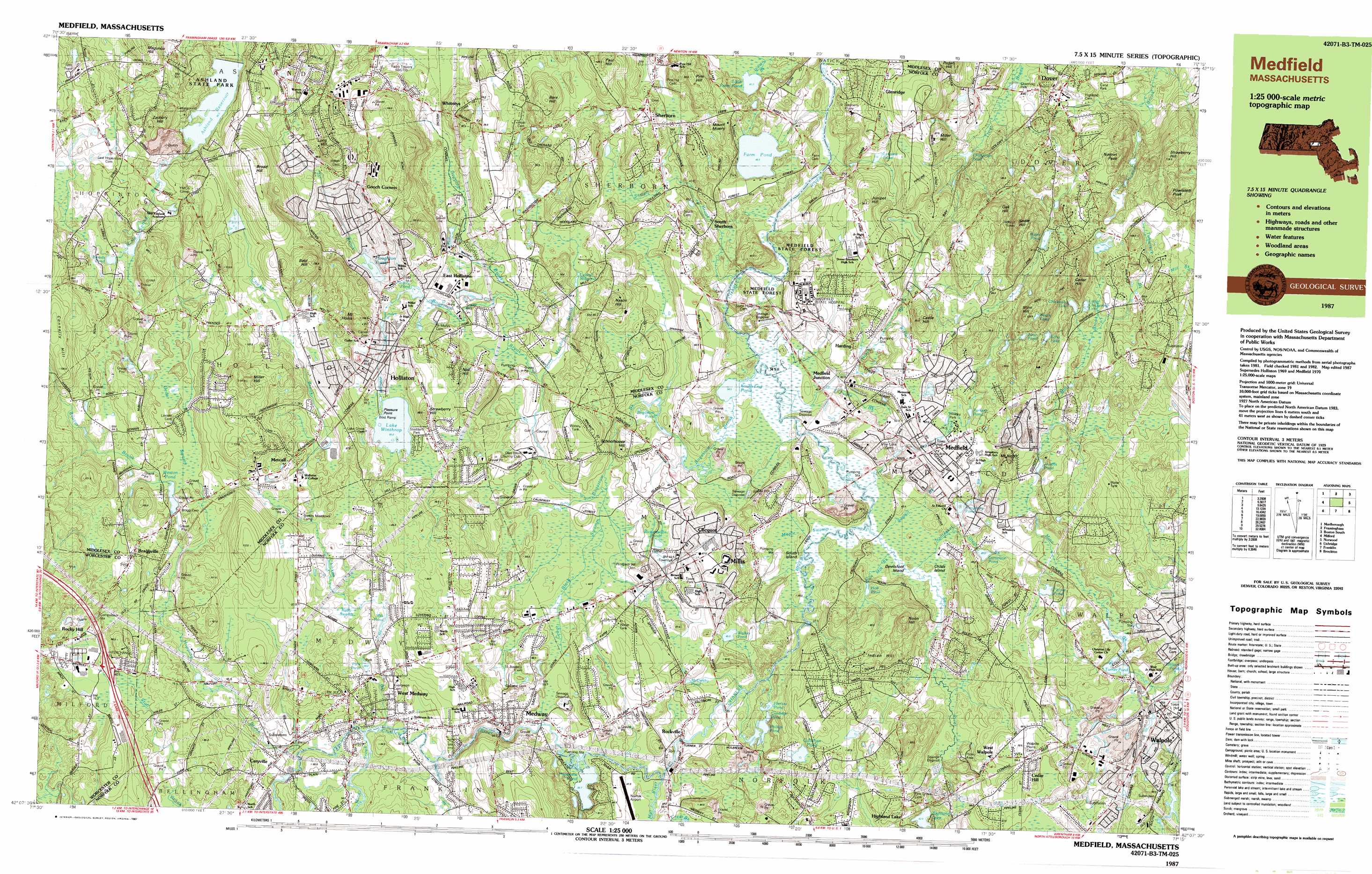
USGS Topo Quad 42071b3 - 1:25,000 scale
| Topo Map Name: | Medfield |
| USGS Topo Quad ID: | 42071b3 |
| Print Size: | ca. 39" wide x 24" high |
| Southeast Coordinates: | 42.125° N latitude / 71.25° W longitude |
| Map Center Coordinates: | 42.1875° N latitude / 71.375° W longitude |
| U.S. State: | MA |
| Filename: | k42071b3.jpg |
| Download Map JPG Image: | Medfield topo map 1:25,000 scale |
| Map Type: | Topographic |
| Topo Series: | 7.5´x15´ |
| Map Scale: | 1:25,000 |
| Source of Map Images: | United States Geological Survey (USGS) |
| Alternate Map Versions: |
Medfield MA 1987, updated 1987 Download PDF Buy paper map Medfield MA 1987, updated 1987 Download PDF Buy paper map |
1:24,000 Topo Quads surrounding Medfield
Hudson |
Concord |
Boston North |
||
Marlborough |
Natick |
Boston South |
||
Milford |
Medfield |
Blue Hills |
||
Blackstone |
Wrentham |
Brockton |
||
Georgiaville |
Attleboro |
Taunton |
> Back to 42071a1 at 1:100,000 scale
> Back to 42070a1 at 1:250,000 scale
> Back to U.S. Topo Maps home
Medfield topo map: Gazetteer
Medfield: Airports
Burke Heliport elevation 77m 252′Davna Corporation Heliport elevation 42m 137′
High School Heliport elevation 80m 262′
Mellen Street Heliport elevation 81m 265′
Nason Hill Heliport elevation 51m 167′
Norfolk Airport (historical) elevation 41m 134′
Oxbow Corporation Heliport elevation 88m 288′
Southend Farm Heliport elevation 38m 124′
Waters Associates Heliport elevation 89m 291′
Medfield: Capes
Pleasure Point elevation 55m 180′Medfield: Crossings
Interchange Thirteen elevation 83m 272′Medfield: Dams
Bogastow Pond Dam elevation 37m 121′Highland Lake Dam elevation 57m 187′
Houghton Pond Dam elevation 54m 177′
Kingsbury Pond Dam elevation 42m 137′
Roaring Brook Pond Dam elevation 58m 190′
Sanford Mill Dam elevation 52m 170′
Turner Pond Dam elevation 46m 150′
West Medway Dam elevation 54m 177′
Medfield: Islands
Childs Island elevation 35m 114′Devilsfoot Island elevation 36m 118′
South Island elevation 40m 131′
Medfield: Lakes
Bloods Pond elevation 80m 262′Callahan Pond elevation 52m 170′
Channings Pond elevation 40m 131′
Chickering Lake elevation 70m 229′
Danielson Pond elevation 43m 141′
Echo Lake elevation 88m 288′
Farm Pond elevation 46m 150′
Flynns Pond elevation 53m 173′
Hales Pond elevation 82m 269′
Highland Lake elevation 57m 187′
Holt Pond elevation 49m 160′
Jewells Pond elevation 51m 167′
June Pond elevation 86m 282′
Lake Winthrop elevation 55m 180′
Lily Pond (historical) elevation 43m 141′
Little Farm Pond elevation 41m 134′
Lymans Pond elevation 55m 180′
McCarthy Pond elevation 58m 190′
Milk Pond elevation 62m 203′
Notch Pond elevation 111m 364′
Populatic Pond elevation 38m 124′
Richardsons Pond elevation 46m 150′
South End Pond elevation 34m 111′
Walker Pond elevation 46m 150′
Medfield: Parks
Ashland State Park elevation 72m 236′Medfield Rhodendron Reservation elevation 34m 111′
Medfield Rhododendron Reservation elevation 35m 114′
Rabbit Hil Historic District elevation 76m 249′
Rocky Narrows Reservation elevation 36m 118′
Sherborn Center Historic District elevation 68m 223′
Stoddard Park elevation 57m 187′
Medfield: Populated Places
Braggville elevation 91m 298′Braggville Station elevation 75m 246′
Camp Bob White elevation 95m 311′
Camp Breezy Meadow elevation 70m 229′
Campbells Station elevation 50m 164′
Caryville elevation 61m 200′
Cedar Hill elevation 69m 226′
Clicquot elevation 47m 154′
Crownridge Estates elevation 52m 170′
Dover elevation 52m 170′
East Holliston elevation 53m 173′
Farm Street Station elevation 53m 173′
Glenridge elevation 75m 246′
Gooch Corners elevation 101m 331′
Harding elevation 51m 167′
Highland Lake elevation 54m 177′
Holliston elevation 59m 193′
Medfield elevation 57m 187′
Medfield Junction elevation 41m 134′
Medway elevation 59m 193′
Metcalf elevation 75m 246′
Millis elevation 53m 173′
Rockville elevation 43m 141′
Rocky Hill elevation 84m 275′
Sherborn elevation 63m 206′
South Sherborn elevation 41m 134′
West Medway elevation 52m 170′
West Walpole elevation 69m 226′
Whitneys elevation 79m 259′
Workmans Circle Camp elevation 57m 187′
Medfield: Post Offices
Caryville Post Office (historical) elevation 62m 203′Holliston Post Office elevation 75m 246′
Medfield Post Office elevation 56m 183′
Medway Post Office elevation 72m 236′
Medway Post Office (historical) elevation 51m 167′
Millis Post Office elevation 44m 144′
Sherborn Post Office elevation 69m 226′
Walpole Post Office elevation 47m 154′
Walpole Post Office (historical) elevation 48m 157′
Medfield: Reservoirs
Bogastow Pond elevation 37m 121′Charles River Reservoir elevation 54m 177′
Coolidge Pond elevation 37m 121′
Factory Pond elevation 50m 164′
Harlow Pond elevation 38m 124′
Houghton Pond elevation 53m 173′
Kingsbury Pond elevation 45m 147′
Leland Millpond elevation 53m 173′
Linden Pond elevation 56m 183′
Mill Pond elevation 41m 134′
Park Pond elevation 56m 183′
Phillips Pond elevation 37m 121′
Roaring Brook Pond elevation 58m 190′
Sanford Mill Pond elevation 52m 170′
Turner Pond elevation 44m 144′
Weston Pond elevation 71m 232′
Medfield: Streams
Beaver Brook elevation 71m 232′Bogastow Brook elevation 35m 114′
Center Brook elevation 64m 209′
Chicken Brook elevation 50m 164′
Deer Brook elevation 73m 239′
Dirty Meadow Brook elevation 44m 144′
Dopping Brook elevation 44m 144′
Hopping Brook elevation 55m 180′
Indian Brook elevation 41m 134′
Jar Brook elevation 50m 164′
Mill Brook elevation 35m 114′
Mill River elevation 45m 147′
Mine Brook elevation 41m 134′
Mine Brook elevation 53m 173′
Nantasket Brook elevation 35m 114′
North Brook elevation 42m 137′
School Meadow Brook elevation 57m 187′
Sewall Brook elevation 36m 118′
Sewall Brook elevation 35m 114′
Shepards Brook elevation 59m 193′
Spring Brook elevation 42m 137′
Stop River elevation 35m 114′
Tubwreck Brook elevation 66m 216′
Vine Brook elevation 61m 200′
Vine Brook elevation 35m 114′
Winthrop Canal elevation 50m 164′
Medfield: Summits
Bald Hill elevation 133m 436′Bare Hill elevation 105m 344′
Broad Hill elevation 125m 410′
Castle Hill elevation 87m 285′
Cedar Hill elevation 133m 436′
College Rock elevation 116m 380′
Connelly Hill elevation 129m 423′
Dirty Meadow Hill elevation 73m 239′
Indian Hill elevation 85m 278′
Juniper Hill elevation 88m 288′
Long Hill elevation 113m 370′
Miller Hill elevation 95m 311′
Miller Hill elevation 124m 406′
Mine Hill elevation 113m 370′
Mount Hollis elevation 60m 196′
Mount Misery elevation 83m 272′
Mount Nebo elevation 75m 246′
Nason Hill elevation 86m 282′
Noanet Peak elevation 110m 360′
Nob Hill elevation 74m 242′
Noon Hill elevation 107m 351′
Oak Hill elevation 112m 367′
Paul Hill elevation 109m 357′
Pine Hill elevation 89m 291′
Powissett Peak elevation 113m 370′
Schoolhouse Hill elevation 54m 177′
Snow Hill elevation 135m 442′
Strawberry Hill elevation 114m 374′
Strawberry Hill elevation 85m 278′
Zachary Hill elevation 109m 357′
Medfield: Swamps
Bogastere Swamp elevation 48m 157′Cedar Swamp elevation 73m 239′
Dapping Brook Swamp elevation 46m 150′
Dirty Meadow Swamp elevation 48m 157′
Great Black Swamp elevation 42m 137′
Kirby Swamp elevation 62m 203′
Maple Swamp elevation 36m 118′
Reserve Pond elevation 70m 229′
Medfield digital topo map on disk
Buy this Medfield topo map showing relief, roads, GPS coordinates and other geographical features, as a high-resolution digital map file on DVD:
Maine, New Hampshire, Rhode Island & Eastern Massachusetts
Buy digital topo maps: Maine, New Hampshire, Rhode Island & Eastern Massachusetts