Hudson Topo Map Massachusetts
To zoom in, hover over the map of Hudson
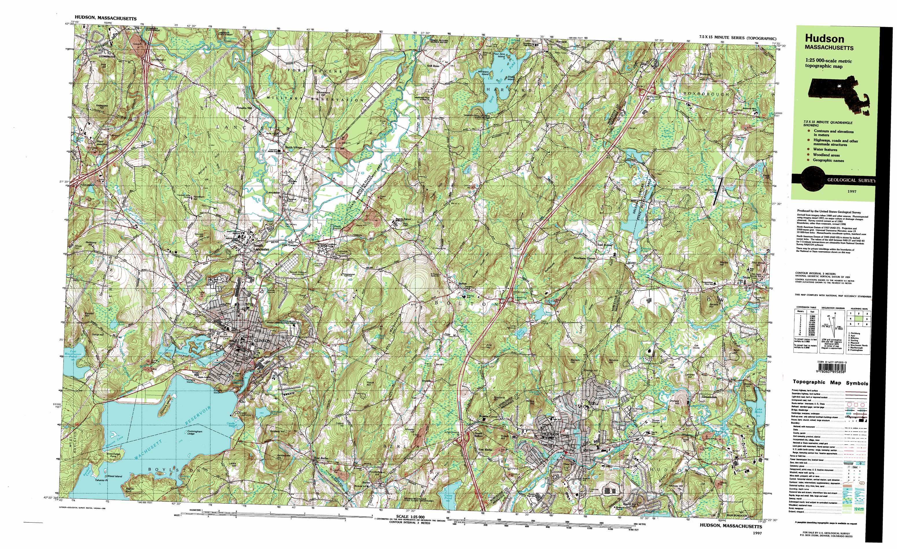
USGS Topo Quad 42071d5 - 1:25,000 scale
| Topo Map Name: | Hudson |
| USGS Topo Quad ID: | 42071d5 |
| Print Size: | ca. 39" wide x 24" high |
| Southeast Coordinates: | 42.375° N latitude / 71.5° W longitude |
| Map Center Coordinates: | 42.4375° N latitude / 71.625° W longitude |
| U.S. State: | MA |
| Filename: | k42071d5.jpg |
| Download Map JPG Image: | Hudson topo map 1:25,000 scale |
| Map Type: | Topographic |
| Topo Series: | 7.5´x15´ |
| Map Scale: | 1:25,000 |
| Source of Map Images: | United States Geological Survey (USGS) |
| Alternate Map Versions: |
Hudson MA 1988, updated 1988 Download PDF Buy paper map Hudson MA 1988, updated 1988 Download PDF Buy paper map Hudson MA 1997, updated 1999 Download PDF Buy paper map |
1:24,000 Topo Quads surrounding Hudson
Ashby |
Pepperell |
Lowell |
||
Fitchburg |
Ayer |
Billerica |
||
Sterling |
Hudson |
Concord |
||
Worcester North |
Marlborough |
Natick |
||
Worcester South |
Milford |
Medfield |
> Back to 42071a1 at 1:100,000 scale
> Back to 42070a1 at 1:250,000 scale
> Back to U.S. Topo Maps home
Hudson topo map: Gazetteer
Hudson: Airports
Digital - Stow Heliport elevation 76m 249′Digital Heliport elevation 89m 291′
Minute Man Airfield elevation 81m 265′
Sheraton Inn Heliport elevation 89m 291′
Hudson: Bays
Carville Basin elevation 117m 383′Hastings Cove elevation 117m 383′
Kendall Cove elevation 117m 383′
Prescott Cove elevation 117m 383′
Hudson: Beaches
Harvard Town Beach elevation 104m 341′Sterling Town Beach elevation 135m 442′
Hudson: Canals
Cosgrove Aqueduct elevation 104m 341′Hudson: Capes
Greenhalge Point elevation 122m 400′Tahanto Point elevation 117m 383′
Hudson: Cliffs
Sawyer Bluff elevation 141m 462′Hudson: Crossings
Interchange Twenty-eight elevation 89m 291′Interchange Twenty-seven elevation 101m 331′
Interchange Twenty-six elevation 110m 360′
Hudson: Dams
Bare Hill Pond Dam elevation 108m 354′Delaney Complex elevation 73m 239′
Delaney Complex elevation 76m 249′
Elizabeth Brook Dam elevation 78m 255′
Horse Meadows Dam elevation 111m 364′
Lower Delaney Pond Dam elevation 69m 226′
Hudson: Falls
Danforth Falls elevation 91m 298′Hudson: Forests
Lancaster State Forest elevation 85m 278′Hudson: Islands
Cemetery Island elevation 127m 416′Cunningham Ledge elevation 117m 383′
Four Acre Island elevation 105m 344′
Ministers Island elevation 109m 357′
Sheep Island elevation 107m 351′
Spectacle Island elevation 105m 344′
Wood Island elevation 121m 396′
Hudson: Lakes
Bartlett Pond elevation 86m 282′Clamshell Pond elevation 119m 390′
East Waushacum Pond elevation 134m 439′
Fitch Pond elevation 147m 482′
Flagg Hill Pond elevation 74m 242′
Four Ponds elevation 116m 380′
Fuller Pond elevation 84m 275′
Little Pond elevation 97m 318′
Mossy Pond elevation 100m 328′
Pratts Pond elevation 134m 439′
Sandy Pond elevation 117m 383′
South Meadow Pond elevation 100m 328′
Welch Pond elevation 154m 505′
West Pond elevation 97m 318′
Hudson: Parks
Bolton Flats Wildlife Management Area elevation 69m 226′Carlisle Park elevation 145m 475′
Carlisle Park elevation 136m 446′
Central Park elevation 111m 364′
Downtown Clinton Historic District elevation 101m 331′
Fiske Hill National Park elevation 127m 416′
Fuller Field elevation 88m 288′
Marble Hill Conservation Area elevation 138m 452′
Oxbow National Wildlife Refuge elevation 79m 259′
Riverside Park elevation 68m 223′
Sholan Park elevation 143m 469′
Hudson: Populated Places
Berlin elevation 100m 328′Bolton elevation 117m 383′
Boxboro elevation 138m 452′
Boylston elevation 117m 383′
Brockway Corner elevation 78m 255′
Browns Corner elevation 93m 305′
Camp Green Eyrie elevation 107m 351′
Camp Resolute elevation 97m 318′
Camp Virginia elevation 106m 347′
Carterville elevation 96m 314′
Clinton elevation 111m 364′
Duck Harbor (historical) elevation 106m 347′
East Berlin elevation 102m 334′
East Bolton elevation 81m 265′
Ebenville elevation 118m 387′
Five Corners elevation 74m 242′
Fryville elevation 121m 396′
Fullerville (historical) elevation 80m 262′
Gates Crossing elevation 124m 406′
Gleasondale elevation 57m 187′
Gleasondale Station elevation 59m 193′
Hudson elevation 67m 219′
Lancaster elevation 94m 308′
Meadowbrook Mobile Home Park elevation 78m 255′
North Village elevation 79m 259′
Ponakin Mill elevation 89m 291′
Pratt Junction elevation 131m 429′
Seventh Day Adventist Village elevation 145m 475′
South Bolton elevation 114m 374′
South Lancaster elevation 87m 285′
Still River elevation 127m 416′
Stow elevation 70m 229′
West Berlin elevation 94m 308′
Hudson: Post Offices
Hudson Post Office elevation 72m 236′Rock Bottom Post Office (historical) elevation 60m 196′
Stow Post Office elevation 62m 203′
Hudson: Reservoirs
Bare Hill Pond elevation 104m 341′Bruces Pond elevation 71m 232′
Coachlace Pond elevation 110m 360′
Delaney Pond elevation 76m 249′
Eldridge Pond elevation 73m 239′
Elizabeth Brook Reservoir elevation 78m 255′
Flagg Hill Pond elevation 86m 282′
Fletchers Pond elevation 62m 203′
Fort Meadow Reservoir elevation 71m 232′
Fuller Pond elevation 81m 265′
Horse Meadows Reservoir elevation 111m 364′
Lake Boon elevation 61m 200′
Lancaster Millpond elevation 97m 318′
Lower Delaney Pond elevation 69m 226′
Tripp Pond elevation 68m 223′
Wachusett Dam elevation 110m 360′
Wachusett Reservoir elevation 108m 354′
Wheeler Pond elevation 62m 203′
Hudson: Springs
Crystal Spring elevation 87m 285′Hudson: Streams
Danforth Brook elevation 64m 209′Fort Meadow Brook elevation 55m 180′
Fosgate Brook elevation 102m 334′
Goodridge Brook elevation 72m 236′
Great Brook elevation 70m 229′
Hog Brook elevation 61m 200′
McGovern Brook elevation 81m 265′
Mill Brook elevation 94m 308′
North Nashua River elevation 72m 236′
Ponakin Brook elevation 75m 246′
Ropers Brook elevation 72m 236′
South Meadow Brook elevation 100m 328′
Spectacle Brook elevation 77m 252′
Still River elevation 66m 216′
Hudson: Summits
Ballard Hill elevation 131m 429′Barretts Hill elevation 144m 472′
Birch Hill elevation 121m 396′
Boons Hill elevation 86m 282′
Burdett Hill elevation 150m 492′
Coburn Hill elevation 151m 495′
George Hill elevation 157m 515′
Gospel Hill elevation 59m 193′
Hawthorn Hill elevation 153m 501′
Honeypot Hill elevation 85m 278′
Lambert Hill elevation 94m 308′
Larkin Hill elevation 173m 567′
Legate Hill elevation 194m 636′
Long Hill elevation 109m 357′
Long Hill elevation 98m 321′
Marble Hill elevation 131m 429′
Orchard Hill elevation 92m 301′
Peach Hill elevation 179m 587′
Phillips Hill elevation 139m 456′
Pilot Grove Hill elevation 101m 331′
Pine Hill elevation 165m 541′
Pine Hill elevation 153m 501′
Pope Hill elevation 103m 337′
Potash Hill elevation 136m 446′
Powder House Hill elevation 160m 524′
Powderhouse Hill elevation 121m 396′
Rattlesnake Hill elevation 135m 442′
Rattlesnake Hill elevation 167m 547′
Rattlesnake Hill elevation 145m 475′
Redstone Hill elevation 207m 679′
Reubens Hill elevation 142m 465′
Round Top Hill elevation 119m 390′
Sawyer Hill elevation 113m 370′
Spectacle Hill elevation 141m 462′
Spindle Hill elevation 124m 406′
Stevens Hill elevation 127m 416′
Stratton Hill elevation 119m 390′
Sweat Hill elevation 185m 606′
Vaughn Hills elevation 160m 524′
Warren Hill elevation 101m 331′
Wataquadock Hill elevation 174m 570′
Wekepeke Hill elevation 186m 610′
Wheeler Hill elevation 158m 518′
Whitney Hill elevation 101m 331′
Whittemore Hill elevation 139m 456′
Wilson Hill elevation 162m 531′
Hudson: Swamps
Hiley Meadows elevation 67m 219′Hog Swamp elevation 107m 351′
Sunk Meadow elevation 111m 364′
Wolf Swamp elevation 88m 288′
Hudson digital topo map on disk
Buy this Hudson topo map showing relief, roads, GPS coordinates and other geographical features, as a high-resolution digital map file on DVD:
Maine, New Hampshire, Rhode Island & Eastern Massachusetts
Buy digital topo maps: Maine, New Hampshire, Rhode Island & Eastern Massachusetts