Ayer Topo Map Massachusetts
To zoom in, hover over the map of Ayer
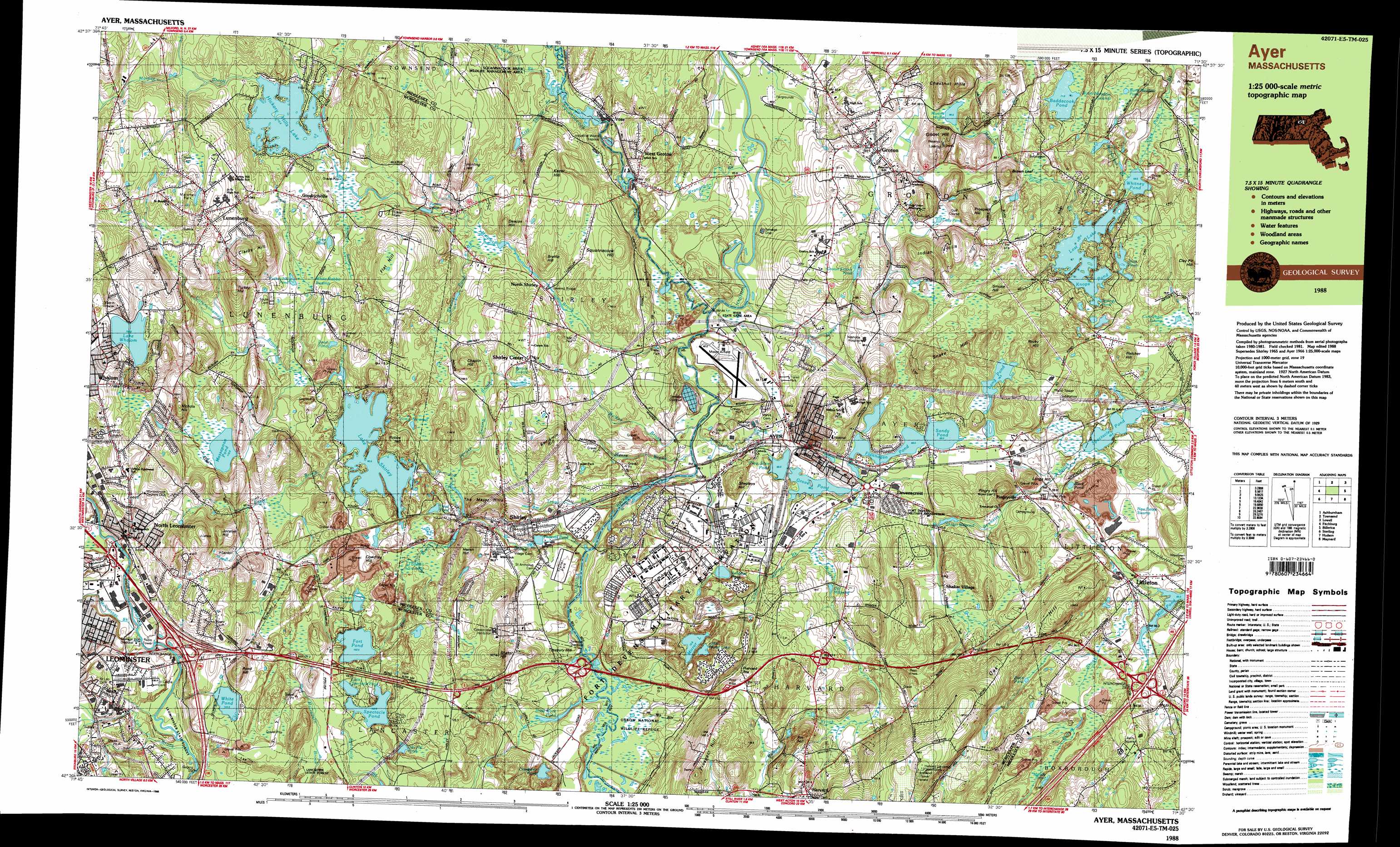
USGS Topo Quad 42071e5 - 1:25,000 scale
| Topo Map Name: | Ayer |
| USGS Topo Quad ID: | 42071e5 |
| Print Size: | ca. 39" wide x 24" high |
| Southeast Coordinates: | 42.5° N latitude / 71.5° W longitude |
| Map Center Coordinates: | 42.5625° N latitude / 71.625° W longitude |
| U.S. State: | MA |
| Filename: | k42071e5.jpg |
| Download Map JPG Image: | Ayer topo map 1:25,000 scale |
| Map Type: | Topographic |
| Topo Series: | 7.5´x15´ |
| Map Scale: | 1:25,000 |
| Source of Map Images: | United States Geological Survey (USGS) |
| Alternate Map Versions: |
Ayer MA 1988, updated 1988 Download PDF Buy paper map Ayer MA 1988, updated 1988 Download PDF Buy paper map |
1:24,000 Topo Quads surrounding Ayer
Greenville |
Milford |
South Merrimack |
Nashua North |
Windham |
Ashby |
Pepperell |
Lowell |
||
Fitchburg |
Ayer |
Billerica |
||
Sterling |
Hudson |
Concord |
||
Worcester North |
Marlborough |
Natick |
> Back to 42071e1 at 1:100,000 scale
> Back to 42070a1 at 1:250,000 scale
> Back to U.S. Topo Maps home
Ayer topo map: Gazetteer
Ayer: Airports
Moore AAF Airport elevation 80m 262′Moore Airfield elevation 77m 252′
Nashoba Community Hospital Heliport elevation 97m 318′
Shirley Airport elevation 117m 383′
Shirley Airport elevation 119m 390′
Ayer: Crossings
Interchange Twenty-nine elevation 70m 229′Ayer: Dams
Balch Pond Dike elevation 72m 236′Bow Brook Dam elevation 88m 288′
Fort Pond Dam elevation 108m 354′
Hickory Hills Lake Dam elevation 114m 374′
Lake Shirley Dam elevation 90m 295′
Lost Lake Dam elevation 65m 213′
Lower Long Pond Dam elevation 71m 232′
Old Pumping Station Dam elevation 72m 236′
Phoenix Pond Dam elevation 73m 239′
Plow Shop Pond Dam elevation 67m 219′
Plow Shop Pond Dike elevation 70m 229′
Squannacook River Dam elevation 71m 232′
Squannacook River Dam elevation 74m 242′
Upper Flannagan Pond Dam elevation 70m 229′
Upper Long Pond Dam elevation 82m 269′
West Main Street Dam elevation 72m 236′
White Pond Dam elevation 124m 406′
Ayer: Lakes
Baddacook Pond elevation 71m 232′Black Pond elevation 68m 223′
Black Pond elevation 79m 259′
Bradaocook Pond elevation 71m 232′
Burnt Meadow Pond elevation 73m 239′
Cady Pond elevation 95m 311′
Cranberry Pond elevation 73m 239′
Dead Pond elevation 107m 351′
Dead Pond elevation 97m 318′
Dead River elevation 62m 203′
Duck Pond elevation 70m 229′
Flannagan Pond elevation 69m 226′
Groton School Pond elevation 88m 288′
Grove Pond elevation 66m 216′
Knops Pond elevation 65m 213′
Lake Whalom elevation 156m 511′
Lane Pond elevation 117m 383′
Little Mirror Lake elevation 73m 239′
Little Spectacle Pond elevation 106m 347′
Long Pond elevation 79m 259′
Martins Pond elevation 96m 314′
Massapoag Pond elevation 110m 360′
Mirror Lake elevation 72m 236′
Muddy Pond elevation 72m 236′
Oak Hill Pond elevation 111m 364′
Perrins Pond elevation 107m 351′
Robbins Pond elevation 74m 242′
Sandy Pond elevation 69m 226′
Spectacle Pond elevation 105m 344′
Spectacle Pond elevation 63m 206′
Springy Pond elevation 65m 213′
Turkey Hill Pond elevation 116m 380′
Turner Pond elevation 112m 367′
Whitney Pond elevation 59m 193′
Ayer: Parks
Desantis Field elevation 138m 452′Harris Field elevation 138m 452′
Harvard Shaker Village Historic District elevation 83m 272′
Lancaster State Forest elevation 110m 360′
Lunenburg Historic District elevation 170m 557′
Marshall Park elevation 175m 574′
Marshall Park elevation 170m 557′
Oxbow National Wildlife Refuge elevation 65m 213′
Shirley Center Historic District elevation 119m 390′
Whalom Park elevation 159m 521′
Ayer: Populated Places
Ayer elevation 73m 239′Devenscrest elevation 91m 298′
Fairlane Mobile Home Park elevation 103m 337′
Goodrichville elevation 130m 426′
Groton elevation 101m 331′
Harvard elevation 127m 416′
Harvard Station elevation 89m 291′
Littleton elevation 71m 232′
Lunenburg elevation 174m 570′
Lunenburg Station elevation 120m 393′
Meadow Wood Trailer Park elevation 119m 390′
North Leominster elevation 123m 403′
North Shirley elevation 87m 285′
Pingryville elevation 78m 255′
Shaker Village elevation 88m 288′
Shaker Village elevation 87m 285′
Shirley elevation 87m 285′
Shirley Center elevation 123m 403′
Vose elevation 78m 255′
West Groton elevation 77m 252′
Whalom elevation 162m 531′
Willows elevation 72m 236′
Woodsville elevation 83m 272′
Ayer: Post Offices
Ayer Post Office elevation 75m 246′Groton Post Office elevation 106m 347′
Lunenburg Post Office elevation 170m 557′
Shirley Post Office elevation 100m 328′
West Groton Post Office elevation 77m 252′
Ayer: Reservoirs
Balch Pond elevation 72m 236′Bow Brook Reservoir elevation 88m 288′
Fort Pond elevation 108m 354′
Hickory Hills Lake elevation 114m 374′
Houghtons Mill Pond elevation 93m 305′
Lake Shirley elevation 94m 308′
Lost Lake elevation 65m 213′
Lower Long Pond elevation 71m 232′
Nashua River Reservoir elevation 72m 236′
Old Millpond elevation 71m 232′
Phoenix Pond elevation 73m 239′
Plow Shop Pond elevation 70m 229′
School House Pond elevation 74m 242′
Shaker Millpond elevation 80m 262′
Squannacook River Reservoir elevation 71m 232′
Squannacook River Reservoir elevation 74m 242′
Upper Flannagan Pond elevation 70m 229′
Upper Long Pond elevation 82m 269′
White Pond elevation 124m 406′
Ayer: Ridges
Oak Hill elevation 84m 275′Ayer: Streams
Baddacook Brook elevation 59m 193′Beaver Pond Brook elevation 85m 278′
Bennetts Brook elevation 64m 209′
Bow Brook elevation 91m 298′
Bowers Brook elevation 68m 223′
Catacoonamug Brook elevation 65m 213′
Cold Spring Brook elevation 68m 223′
Easter Brook elevation 93m 305′
Fall Brook elevation 85m 278′
Half Moon Brook elevation 66m 216′
James Brook elevation 63m 206′
Long Pond Brook elevation 71m 232′
Martins Pond Brook elevation 71m 232′
Monoosnoc Brook elevation 90m 295′
Morse Brook elevation 63m 206′
Mulpus Brook elevation 62m 203′
Nonacoicus Brook elevation 63m 206′
Pumpkin Brook elevation 75m 246′
Spruce Swamp Brook elevation 84m 275′
Squannacook River elevation 62m 203′
Trap Swamp Brook elevation 75m 246′
Trout Brook elevation 65m 213′
Walker Brook elevation 63m 206′
Willow Branch elevation 61m 200′
Wrangling Brook elevation 61m 200′
Ayer: Summits
Benjamin Hill elevation 144m 472′Brattle Hill elevation 120m 393′
Brown Hill elevation 105m 344′
Brown Loaf elevation 141m 462′
Chaplin Hill elevation 140m 459′
Chestnut Hills elevation 110m 360′
Clarks Hill elevation 179m 587′
Cowdray Hill elevation 122m 400′
Deacon Hill elevation 125m 410′
Flat Hill elevation 161m 528′
Fletcher Hill elevation 103m 337′
Gibbet Hill elevation 140m 459′
Hazen Hill elevation 136m 446′
Hunting Hill elevation 160m 524′
Indian Hills elevation 111m 364′
Jocelyn Hill elevation 182m 597′
Kezar Hill elevation 136m 446′
Longs Hill elevation 108m 354′
Nichols Hill elevation 163m 534′
Nonaicoicus Hill elevation 117m 383′
Pin Hill elevation 129m 423′
Pingry Hill elevation 134m 439′
Pond Hill elevation 169m 554′
Prospect Hill elevation 149m 488′
Prospect Hill elevation 109m 357′
Robbs Hill elevation 126m 413′
Rocky Hill elevation 131m 429′
Shaker Hill elevation 118m 387′
Shepleys Hill elevation 110m 360′
Smoke Hill elevation 84m 275′
Snake Hill elevation 105m 344′
Squannacook Hill elevation 128m 419′
The Major Hills elevation 98m 321′
Treasury Hill elevation 75m 246′
Turkey Hill elevation 172m 564′
Ayer: Swamps
Browns Swamp elevation 68m 223′Burnt Meadow Swamp elevation 73m 239′
Carmichael Swamp elevation 68m 223′
Cow Pond Meadow elevation 65m 213′
Flurcum Swamp elevation 116m 380′
Long Swamp elevation 97m 318′
New Estate Swamp elevation 69m 226′
Spruce Swamp elevation 112m 367′
Tophet Swamp elevation 90m 295′
White Rabbit Swamp elevation 114m 374′
Ayer digital topo map on disk
Buy this Ayer topo map showing relief, roads, GPS coordinates and other geographical features, as a high-resolution digital map file on DVD:
Maine, New Hampshire, Rhode Island & Eastern Massachusetts
Buy digital topo maps: Maine, New Hampshire, Rhode Island & Eastern Massachusetts