Haverhill Topo Map Massachusetts
To zoom in, hover over the map of Haverhill
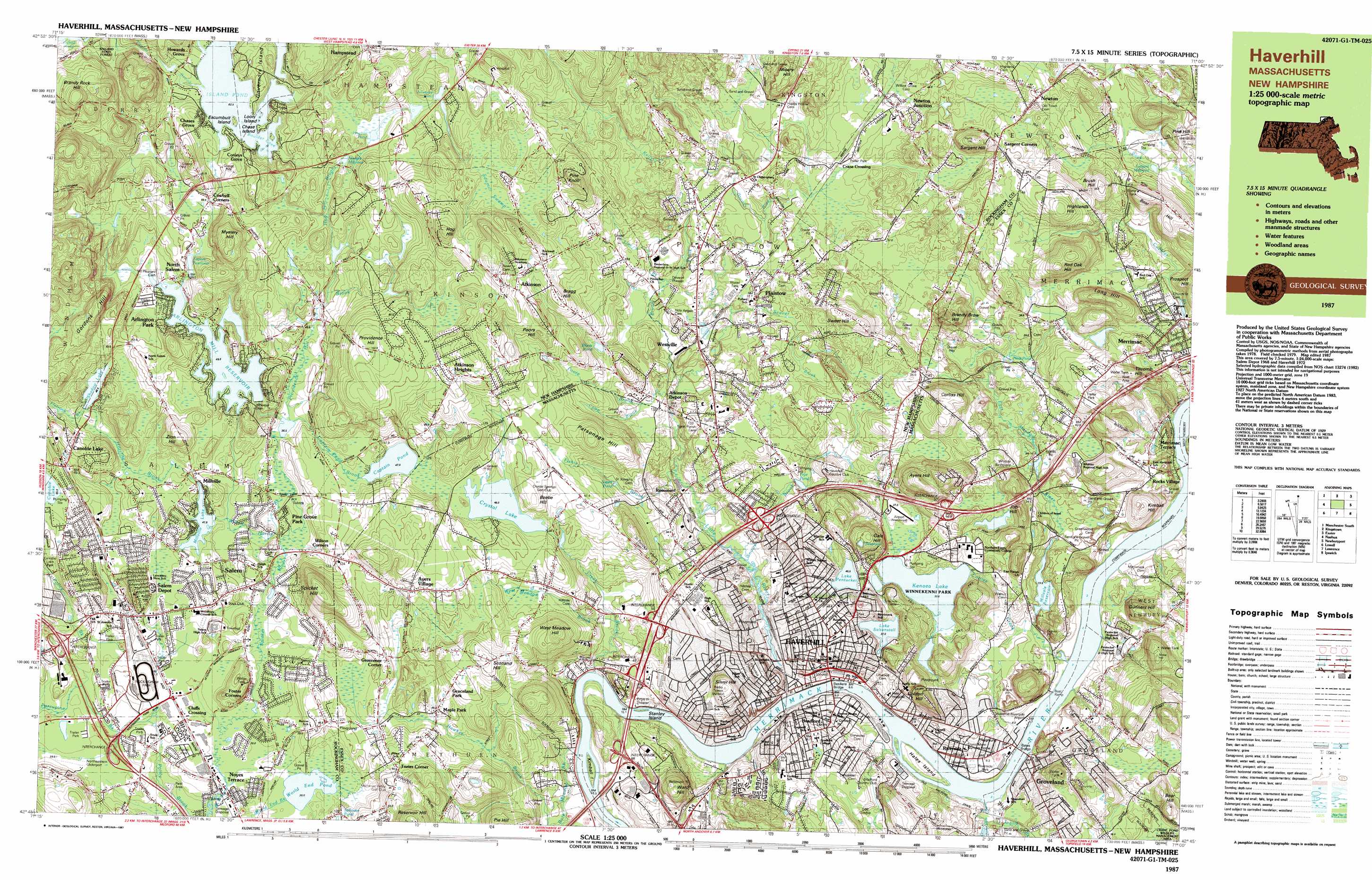
USGS Topo Quad 42071g1 - 1:25,000 scale
| Topo Map Name: | Haverhill |
| USGS Topo Quad ID: | 42071g1 |
| Print Size: | ca. 39" wide x 24" high |
| Southeast Coordinates: | 42.75° N latitude / 71° W longitude |
| Map Center Coordinates: | 42.8125° N latitude / 71.125° W longitude |
| U.S. States: | MA, NH |
| Filename: | k42071g1.jpg |
| Download Map JPG Image: | Haverhill topo map 1:25,000 scale |
| Map Type: | Topographic |
| Topo Series: | 7.5´x15´ |
| Map Scale: | 1:25,000 |
| Source of Map Images: | United States Geological Survey (USGS) |
| Alternate Map Versions: |
Haverhill MA 1985, updated 1986 Download PDF Buy paper map Haverhill MA 1987, updated 1987 Download PDF Buy paper map Haverhill MA 1987, updated 1987 Download PDF Buy paper map |
1:24,000 Topo Quads surrounding Haverhill
Candia |
Mount Pawtuckaway |
Epping |
Newmarket |
Portsmouth |
Derry |
Sandown |
Kingston |
Hampton |
|
Windham |
Haverhill |
Newburyport East |
||
Lowell |
South Groveland |
Ipswich |
||
Billerica |
Reading |
Salem |
> Back to 42071e1 at 1:100,000 scale
> Back to 42070a1 at 1:250,000 scale
> Back to U.S. Topo Maps home
Haverhill topo map: Gazetteer
Haverhill: Airports
Chopper One Heliport elevation 58m 190′Digital New Salem Heliport elevation 81m 265′
Goddard Airport elevation 56m 183′
Gordon Brown Heliport elevation 102m 334′
Haverhill - Riverside Airport elevation 4m 13′
New England Gliderport elevation 38m 124′
Northeastern Gliderport elevation 38m 124′
Wickson Heliport elevation 62m 203′
Haverhill: Bays
Boulder Cove elevation 62m 203′Haverhill: Bridges
Bates Bridge elevation 0m 0′Haverhill: Crossings
Interchange 1 elevation 42m 137′Interchange 2 elevation 49m 160′
Interchange Forty elevation 48m 157′
Interchange Thirty Eight elevation 30m 98′
Interchange Thirty Nine elevation 21m 68′
Interchange Thirty Seven elevation 18m 59′
Interchange Thirty Six elevation 12m 39′
Haverhill: Dams
Arlington Mill Reservoir East Dike elevation 49m 160′Arlington Mill Reservoir West Dike elevation 50m 164′
Big Island Pond Dam elevation 63m 206′
Crystal Lake Dam elevation 45m 147′
Kenoza Ave Pond Dam elevation 37m 121′
Kenoza Lake Dam elevation 32m 104′
Lake Saltonstall Outlet Dam elevation 40m 131′
Millvale Reservoir Dam elevation 26m 85′
Millville Reservoir Dam elevation 40m 131′
Shadow Lake Dam elevation 51m 167′
Stephens Dam elevation 7m 22′
Taylor Dam elevation 58m 190′
Wheeler Dam elevation 46m 150′
Wheeler Dam elevation 48m 157′
Haverhill: Forests
Ballard State Forest elevation 85m 278′Haverhill: Islands
Chase Island elevation 64m 209′Escumbuit Island elevation 64m 209′
Governors Island elevation 73m 239′
Hales Island elevation 5m 16′
Kimball Island elevation 7m 22′
Loon Island elevation 62m 203′
Stanley Island elevation 2m 6′
Haverhill: Lakes
Blunts Pond elevation 31m 101′Captain Pond elevation 47m 154′
Frye Pond elevation 22m 72′
Hodges Millpond elevation 61m 200′
Hog Hill Pond elevation 64m 209′
Lake Pentucket elevation 46m 150′
Sargent Millpond elevation 34m 111′
Sisters Pond elevation 55m 180′
World End Pond elevation 35m 114′
Haverhill: Parks
Bradford Common Historic District elevation 20m 65′Canobie Lake Park elevation 72m 236′
Haverhill Stadium elevation 5m 16′
Passaqua Playground elevation 38m 124′
Riveride Park elevation 4m 13′
Rockingham Park elevation 42m 137′
Winnekenni Park elevation 36m 118′
Haverhill: Populated Places
Arlington Park elevation 50m 164′Atkinson elevation 91m 298′
Atkinson Heights elevation 87m 285′
Ayers Village elevation 56m 183′
Bradford elevation 15m 49′
Canobie Lake elevation 63m 206′
Chases Grove elevation 63m 206′
Cluffs Crossing elevation 38m 124′
Conleys Grove elevation 73m 239′
Cowbell Corners elevation 59m 193′
Crane Crossing elevation 34m 111′
Foster Corners elevation 37m 121′
Graceland Park elevation 58m 190′
Grosvenor Corner elevation 50m 164′
Groveland elevation 14m 45′
Hampstead elevation 100m 328′
Haverhill elevation 15m 49′
Highlands elevation 42m 137′
Highlandville elevation 51m 167′
Howards Grove elevation 67m 219′
Maple Park elevation 47m 154′
Merrimac elevation 31m 101′
Millville elevation 44m 144′
Newton elevation 61m 200′
Newton Junction elevation 39m 127′
North Salem elevation 54m 177′
Noyes Terrace elevation 38m 124′
Pine Grove Park elevation 42m 137′
Plaistow elevation 31m 101′
Riverside elevation 11m 36′
Rocks Village elevation 7m 22′
Rosemont elevation 19m 62′
Salem elevation 39m 127′
Salem Depot elevation 48m 157′
Sargent Corners elevation 56m 183′
Tozier Corner elevation 60m 196′
Ward Hill elevation 17m 55′
West Parish elevation 41m 134′
Westville elevation 45m 147′
Wilson Corners elevation 58m 190′
Haverhill: Post Offices
Bradford Post Office (historical) elevation 25m 82′East Haverhill Post Office (historical) elevation 32m 104′
Haverhill Post Office elevation 7m 22′
Merrimac Post Office (historical) elevation 28m 91′
Salem Depot Post Office elevation 39m 127′
Haverhill: Rapids
Mitchels Falls elevation 0m 0′Haverhill: Reservoirs
Arlington Mill Reservoir elevation 49m 160′Arlington Mill Reservoir elevation 50m 164′
Arlington Mill Reservoir elevation 48m 157′
Arlington Mill Reservoir elevation 46m 150′
Big Island Pond elevation 63m 206′
Crystal Lake Reservoir elevation 45m 147′
Island Pond elevation 61m 200′
Johnsons Pond elevation 68m 223′
Kenoza Lake elevation 32m 104′
Lake Saltonstall elevation 40m 131′
Little River Reservoir elevation 7m 22′
Millvale Reservoir elevation 13m 42′
Millville Lake elevation 40m 131′
Shadow Lake elevation 51m 167′
Taylor Reservoir elevation 58m 190′
Taylors Reservoir elevation 54m 177′
Haverhill: Streams
Bare Meadow Brook elevation 4m 13′Bryant Brook elevation 12m 39′
Camp Brook elevation 20m 65′
Captain Pond Brook elevation 36m 118′
Creek Brook elevation 1m 3′
Drew Brook elevation 62m 203′
East Meadow River elevation 9m 29′
East Meadow River elevation 0m 0′
Fishin Brook elevation 8m 26′
Flatrock Brook elevation 47m 154′
Foote Brook elevation 13m 42′
Foote Brook elevation 13m 42′
Hittytity Brook elevation 43m 141′
Hog Hill Brook elevation 41m 134′
Johnson Creek elevation 0m 0′
Kelly Brook elevation 29m 95′
Line Brook elevation 23m 75′
Little River elevation 6m 19′
Little River elevation 0m 0′
Porcupine Brook elevation 35m 114′
Providence Hill Brook elevation 36m 118′
Seaver Brook elevation 17m 55′
Snows Brook elevation 7m 22′
Taylor Brook elevation 62m 203′
West Meadow Brook elevation 13m 42′
Widow Harris Brook elevation 36m 118′
Haverhill: Summits
Ayers Hill elevation 100m 328′Bear Hill elevation 61m 200′
Beebe Hill elevation 72m 236′
Bragg Hill elevation 94m 308′
Brandy Brow Hill elevation 86m 282′
Brandy Brow Hill elevation 85m 278′
Brandy Rock Hill elevation 139m 456′
Brush Hill elevation 77m 252′
Corliss Hill elevation 85m 278′
Golden Hill elevation 59m 193′
Gordons Hill elevation 115m 377′
Highlands Hill elevation 88m 288′
Hog Hill elevation 128m 419′
Job Hill elevation 70m 229′
Kimball Hill elevation 61m 200′
Long Hill elevation 79m 259′
Misery Hill elevation 79m 259′
Mount Perry elevation 63m 206′
Mystery Hill elevation 112m 367′
Parsonage Hill elevation 60m 196′
Pine Hill elevation 59m 193′
Pine Hill elevation 59m 193′
Pine Knoll elevation 109m 357′
Poors Hill elevation 92m 301′
Providence Hill elevation 103m 337′
Red Oak Hill elevation 92m 301′
Reservoir Hill elevation 107m 351′
Sargent Hill elevation 85m 278′
Scotland Hill elevation 84m 275′
Silver Hill elevation 82m 269′
Spicket Hill elevation 112m 367′
Spicket Hill elevation 112m 367′
Sweet Hill elevation 85m 278′
Titcomb Hill elevation 70m 229′
Ward Hill elevation 85m 278′
West Meadow Hill elevation 83m 272′
Zion Hill elevation 85m 278′
Haverhill: Swamps
Neal Pond elevation 21m 68′Sawmill Swamp elevation 80m 262′
Haverhill digital topo map on disk
Buy this Haverhill topo map showing relief, roads, GPS coordinates and other geographical features, as a high-resolution digital map file on DVD:
Maine, New Hampshire, Rhode Island & Eastern Massachusetts
Buy digital topo maps: Maine, New Hampshire, Rhode Island & Eastern Massachusetts