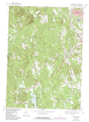
Pinardville Topo Map New Hampshire
To zoom in, hover over the map of Pinardville
USGS Topo Quad 42071h5 - 1:24,000 scale
| Topo Map Name: | Pinardville |
| USGS Topo Quad ID: | 42071h5 |
| Print Size: | ca. 21 1/4" wide x 27" high |
| Southeast Coordinates: | 42.875° N latitude / 71.5° W longitude |
| Map Center Coordinates: | 42.9375° N latitude / 71.5625° W longitude |
| U.S. State: | NH |
| Filename: | o42071h5.jpg |
| Download Map JPG Image: | Pinardville topo map 1:24,000 scale |
| Map Type: | Topographic |
| Topo Series: | 7.5´ |
| Map Scale: | 1:24,000 |
| Source of Map Images: | United States Geological Survey (USGS) |
| Alternate Map Versions: |
Pinardville NH 1968, updated 1971 Download PDF Buy paper map Pinardville NH 1968, updated 1985 Download PDF Buy paper map Pinardville NH 1968, updated 1985 Download PDF Buy paper map Pinardville NH 2012 Download PDF Buy paper map Pinardville NH 2015 Download PDF Buy paper map |
1:24,000 Topo Quads surrounding Pinardville
> Back to 42071e1 at 1:100,000 scale
> Back to 42070a1 at 1:250,000 scale
> Back to U.S. Topo Maps home
Pinardville topo map: Gazetteer
Pinardville: Airports
Dean Kamen II Heliport elevation 143m 469′Sams Heliport elevation 189m 620′
Pinardville: Basins
The Pulpit elevation 156m 511′Pinardville: Bays
Washer Cove elevation 71m 232′Pinardville: Capes
High Point elevation 71m 232′Pinardville: Dams
Lower Reservoir Dam elevation 150m 492′Uncanoonuc Lake Dam Number 2 elevation 199m 652′
Uncanoonuc Lake Dike elevation 199m 652′
Upper Reservoir Dam elevation 160m 524′
Pinardville: Islands
Clark Island elevation 75m 246′Pinardville: Lakes
Baboosic Lake elevation 71m 232′Damon Pond elevation 73m 239′
Jakes Pond elevation 100m 328′
Lincoln Pond elevation 83m 272′
Little Baboosic Lake elevation 71m 232′
Maddening Ponds elevation 222m 728′
McMahons Pond elevation 121m 396′
Pinardville: Populated Places
Bedford elevation 93m 305′Browns Corner elevation 224m 734′
Klondike Corner elevation 172m 564′
Mountain Base elevation 205m 672′
Pinardville elevation 81m 265′
Pinardville: Reservoirs
Goffstown Reservoirs elevation 155m 508′Lower Reservoir elevation 150m 492′
Uncanoonuc Lake elevation 199m 652′
Upper Reservoir elevation 160m 524′
Pinardville: Streams
Joe English Brook elevation 71m 232′McQuade Brook elevation 53m 173′
Pulpit Brook elevation 67m 219′
Riddle Brook elevation 52m 170′
Pinardville: Summits
Beards Hill elevation 143m 469′Bells Hill elevation 130m 426′
Benson Hill elevation 248m 813′
Bumbo Hill elevation 113m 370′
Chestnut Hill elevation 265m 869′
Cricket Hill elevation 142m 465′
Holbrook Hill elevation 256m 839′
Joppa Hill elevation 170m 557′
Laurel Hill elevation 144m 472′
Ledge Hill elevation 182m 597′
North Mountain elevation 401m 1315′
Powder Hill elevation 185m 606′
Rundlett Hill elevation 125m 410′
Shirley Hill elevation 251m 823′
South Mountain elevation 396m 1299′
Strawberry Hill elevation 145m 475′
Telford Hill elevation 220m 721′
Tirrell Hill elevation 137m 449′
Uncanoonuc Mountains elevation 402m 1318′
Walnut Hill elevation 186m 610′
Walnut Hill elevation 202m 662′
Pinardville digital topo map on disk
Buy this Pinardville topo map showing relief, roads, GPS coordinates and other geographical features, as a high-resolution digital map file on DVD:
Maine, New Hampshire, Rhode Island & Eastern Massachusetts
Buy digital topo maps: Maine, New Hampshire, Rhode Island & Eastern Massachusetts


