West Springfield Topo Map Massachusetts
To zoom in, hover over the map of West Springfield
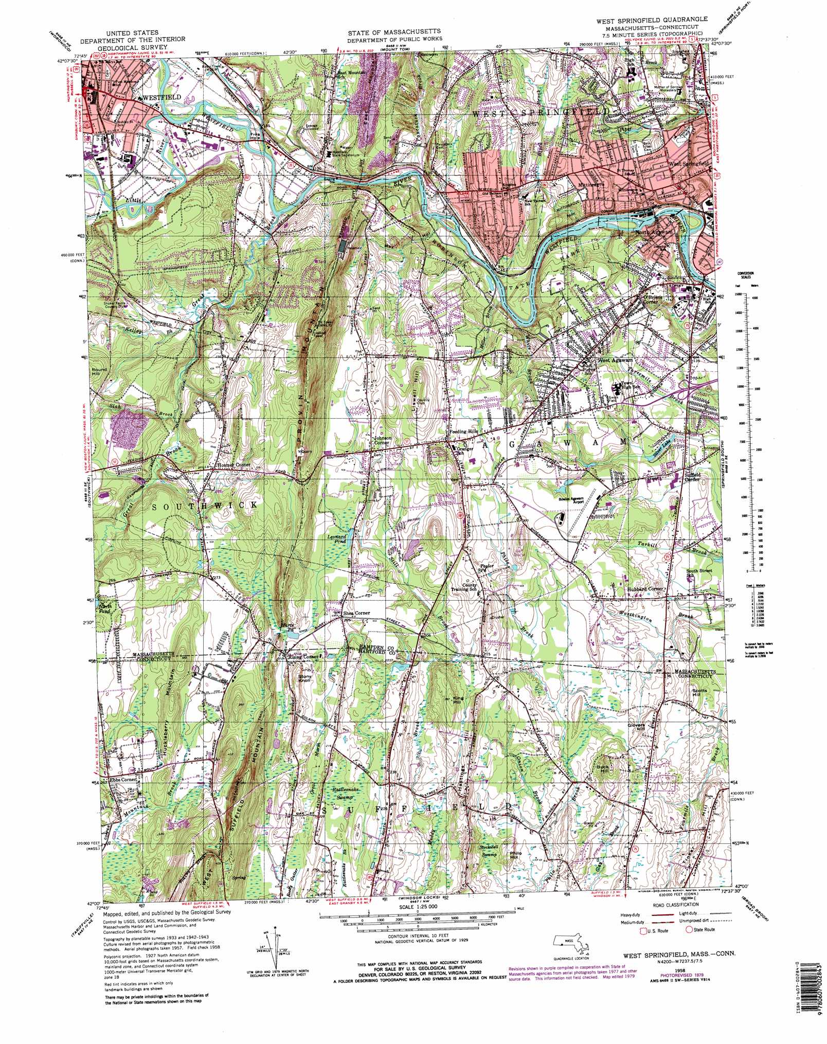
USGS Topo Quad 42072a6 - 1:25,000 scale
| Topo Map Name: | West Springfield |
| USGS Topo Quad ID: | 42072a6 |
| Print Size: | ca. 21 1/4" wide x 27" high |
| Southeast Coordinates: | 42° N latitude / 72.625° W longitude |
| Map Center Coordinates: | 42.0625° N latitude / 72.6875° W longitude |
| U.S. States: | MA, CT |
| Filename: | l42072a6.jpg |
| Download Map JPG Image: | West Springfield topo map 1:25,000 scale |
| Map Type: | Topographic |
| Topo Series: | 7.5´ |
| Map Scale: | 1:25,000 |
| Source of Map Images: | United States Geological Survey (USGS) |
| Alternate Map Versions: |
West Springfield MA 1958, updated 1979 Download PDF Buy paper map West Springfield MA 1975, updated 1981 Download PDF Buy paper map |
1:24,000 Topo Quads surrounding West Springfield
Westhampton |
Easthampton |
Mount Holyoke |
Belchertown |
|
Woronoco |
Mount Tom |
Springfield North |
Ludlow |
|
Southwick |
West Springfield |
Springfield South |
Hampden |
|
New Hartford |
Tariffville |
Windsor Locks |
Broad Brook |
Ellington |
Collinsville |
Avon |
Hartford North |
Manchester |
Rockville |
> Back to 42072a1 at 1:100,000 scale
> Back to 42072a1 at 1:250,000 scale
> Back to U.S. Topo Maps home
West Springfield topo map: Gazetteer
West Springfield: Airports
Lumber Jack Field elevation 56m 183′Micron Heliport elevation 71m 232′
Scibelli Heliport elevation 72m 236′
TGP Heliport elevation 39m 127′
Vergnani Heliport elevation 55m 180′
West Springfield: Bends
Frog Hole elevation 42m 137′West Springfield: Canals
Hampshire and Hampden Canal elevation 44m 144′Hampshire and Hampden Canal elevation 56m 183′
Springfield Aqueduct elevation 63m 206′
West Springfield: Dams
Nine Lot Dam elevation 65m 213′Provin Mountain Reservoir Dam elevation 110m 360′
Provost Dam elevation 53m 173′
Strathmore Paper Company Dam elevation 31m 101′
West Springfield Fish and Game Club Dam elevation 54m 177′
West Springfield: Forests
Jesse F Smith Memorial Forest elevation 53m 173′West Springfield: Lakes
Harts Pond elevation 69m 226′Leonard Pond elevation 63m 206′
Taylor Pond elevation 67m 219′
West Springfield: Parks
Cross Street Playground elevation 40m 131′Hastings Hill Historic District elevation 78m 255′
Mittineague Park elevation 42m 137′
Perry Lane Park elevation 33m 108′
Robinson State Park elevation 44m 144′
Shea Field elevation 61m 200′
Smith Field elevation 66m 216′
Veterans Field elevation 42m 137′
Wade Park elevation 64m 209′
West Springfield: Populated Places
Ebbs Corner elevation 81m 265′Feeding Hills elevation 68m 223′
Halladay Corner elevation 55m 180′
Hosmer Corner elevation 76m 249′
Hubbard Corner elevation 40m 131′
Johnson Corner elevation 72m 236′
Little River elevation 41m 134′
Mittineague elevation 62m 203′
North Agawam elevation 34m 111′
O'Briens Corner elevation 57m 187′
Paucatuck (historical) elevation 43m 141′
Rising Corner elevation 75m 246′
Shea Corner elevation 64m 209′
Springfield Hill elevation 70m 229′
Suffield Corner elevation 39m 127′
Tatham elevation 40m 131′
West Agawam elevation 63m 206′
West Springfield: Post Offices
Feeding Hills Post Office elevation 67m 219′West Springfield: Reservoirs
Provin Mountain Reservoir elevation 110m 360′Silver Lake elevation 42m 137′
Silver Lake Reservoir elevation 45m 147′
Spears Pond elevation 57m 187′
Westfield River Reservoir elevation 31m 101′
West Springfield: Streams
Block Brook elevation 34m 111′Great Brook elevation 36m 118′
Hundred Acre Brook elevation 44m 144′
Kellog Brook elevation 43m 141′
Little River elevation 43m 141′
Miller Brook elevation 41m 134′
Onion Brook elevation 41m 134′
Paucatuck Brook elevation 39m 127′
Pond Brook elevation 34m 111′
Powdermill Brook elevation 42m 137′
Slab Brook elevation 58m 190′
Still Brook elevation 55m 180′
Still Brook elevation 62m 203′
White Brook elevation 47m 154′
West Springfield: Summits
Buck Hill elevation 77m 252′Glovers Hill elevation 56m 183′
Hastings Hill elevation 72m 236′
Huckleberry Mountain elevation 101m 331′
Kelly Hill elevation 114m 374′
King Hill elevation 83m 272′
Liswell Hill elevation 100m 328′
Philo Hill elevation 55m 180′
Provin Mountain elevation 159m 521′
Scott Hill elevation 43m 141′
Stony Knoll elevation 82m 269′
Tinker Hill elevation 53m 173′
West Suffield Mountain elevation 184m 603′
West Springfield: Swamps
Great Marsh elevation 73m 239′Rattlesnake Swamp elevation 66m 216′
Stockwell Swamp elevation 51m 167′
West Springfield: Valleys
May Hollow elevation 39m 127′West Springfield digital topo map on disk
Buy this West Springfield topo map showing relief, roads, GPS coordinates and other geographical features, as a high-resolution digital map file on DVD:
New York, Vermont, Connecticut & Western Massachusetts
Buy digital topo maps: New York, Vermont, Connecticut & Western Massachusetts