Southwick Topo Map Massachusetts
To zoom in, hover over the map of Southwick
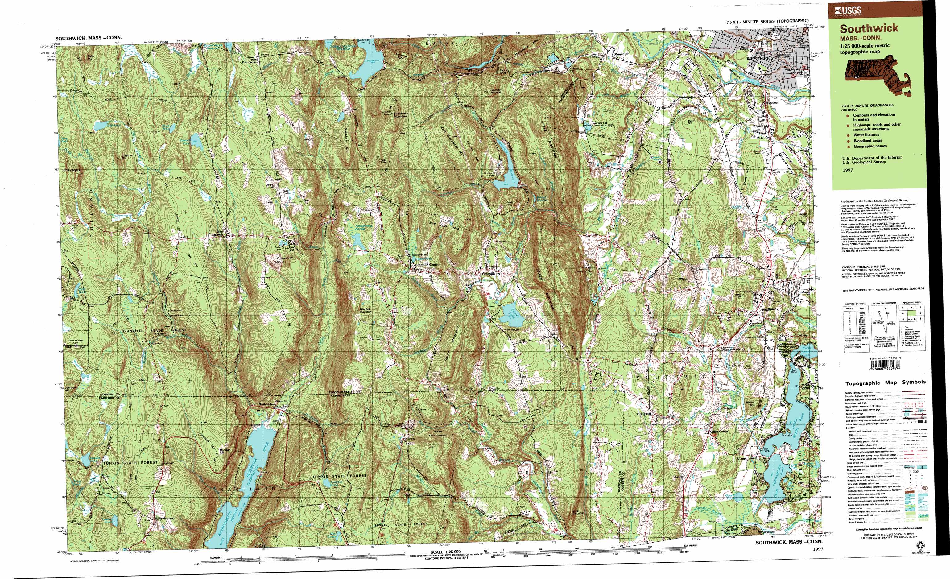
USGS Topo Quad 42072a7 - 1:25,000 scale
| Topo Map Name: | Southwick |
| USGS Topo Quad ID: | 42072a7 |
| Print Size: | ca. 39" wide x 24" high |
| Southeast Coordinates: | 42° N latitude / 72.75° W longitude |
| Map Center Coordinates: | 42.0625° N latitude / 72.875° W longitude |
| U.S. States: | MA, CT |
| Filename: | k42072a7.jpg |
| Download Map JPG Image: | Southwick topo map 1:25,000 scale |
| Map Type: | Topographic |
| Topo Series: | 7.5´x15´ |
| Map Scale: | 1:25,000 |
| Source of Map Images: | United States Geological Survey (USGS) |
| Alternate Map Versions: |
Southwick MA 1987, updated 1988 Download PDF Buy paper map Southwick MA 1997, updated 2000 Download PDF Buy paper map |
1:24,000 Topo Quads surrounding Southwick
Becket |
Westhampton |
Easthampton |
Mount Holyoke |
|
Otis |
Woronoco |
Mount Tom |
Springfield North |
|
Tolland Center |
Southwick |
West Springfield |
Springfield South |
|
Winsted |
New Hartford |
Tariffville |
Windsor Locks |
Broad Brook |
Torrington |
Collinsville |
Avon |
Hartford North |
Manchester |
> Back to 42072a1 at 1:100,000 scale
> Back to 42072a1 at 1:250,000 scale
> Back to U.S. Topo Maps home
Southwick topo map: Gazetteer
Southwick: Airports
Congamond Lake Heliport elevation 69m 226′Morehaven Airport elevation 348m 1141′
Mundale Airport elevation 85m 278′
South Pond Seaplane Base elevation 81m 265′
Southwick: Bays
Conn Cove elevation 69m 226′Southwick: Beaches
Babbs Beach elevation 69m 226′Southwick: Bridges
Hortons Bridge elevation 62m 203′Southwick: Canals
Wild Cat Aqueduct elevation 299m 980′Southwick: Dams
Congamond Lakes Middle Dike elevation 69m 226′Congamond Lakes North Dike elevation 76m 249′
Congamond Lakes South Dike elevation 78m 255′
Cooley Lake Dam elevation 193m 633′
Fosters Pond Dam elevation 361m 1184′
Granville Reservoir Dam elevation 168m 551′
Howells Pond Dam elevation 345m 1131′
Logie Dam Dropped elevation 96m 314′
Phelon Pond Dam elevation 354m 1161′
Springfield Water Works Intake Dam elevation 167m 547′
Stevens Paper Company Lower Dam elevation 50m 164′
Stevens Paper Company Upper Dam elevation 57m 187′
Trout Pond Dam elevation 403m 1322′
West Parish Filter Number One Dam elevation 128m 419′
West Parish Filter Number Three Dam elevation 148m 485′
West Parish Filter Number Two Dam elevation 135m 442′
Southwick: Flats
Wolfpit Meadows elevation 51m 167′Southwick: Forests
Granville State Forest elevation 364m 1194′Tunxis State Forest elevation 319m 1046′
Southwick: Lakes
Arnold Pond elevation 77m 252′Black Pond elevation 417m 1368′
Carson Pond elevation 153m 501′
Congamond Lakes elevation 69m 226′
Degano Pond elevation 317m 1040′
Emmons Pond elevation 334m 1095′
Fosters Pond elevation 352m 1154′
Goose Pond elevation 69m 226′
Hall Pond elevation 385m 1263′
Limon Pond elevation 74m 242′
May Ponds elevation 358m 1174′
Middle Pond elevation 69m 226′
North Pond elevation 69m 226′
Parsons Pond elevation 396m 1299′
South Pond elevation 69m 226′
Spencer Pond elevation 79m 259′
Trout Pond elevation 348m 1141′
Southwick: Parks
Allen Park elevation 53m 173′Babbs Beach Recreation Area elevation 74m 242′
Holcomb Park elevation 63m 206′
Southwick: Plains
Poverty Plains elevation 79m 259′Southwick: Populated Places
Baird Four Corners elevation 366m 1200′Camp Berkshire elevation 83m 272′
Congamond elevation 78m 255′
Gillett Corner elevation 93m 305′
Granville elevation 211m 692′
Granville Center elevation 315m 1033′
Mundale elevation 85m 278′
North Hollow elevation 169m 554′
Southwick elevation 81m 265′
Vining Hill elevation 137m 449′
West Granville elevation 361m 1184′
West Hartland elevation 354m 1161′
Southwick: Post Offices
Southwick Post Office elevation 86m 282′West Hartland Post Office elevation 360m 1181′
Southwick: Reservoirs
Congamond Lakes Middle Pond elevation 69m 226′Congamond Lakes North Pond elevation 76m 249′
Congamond Lakes South Pond elevation 78m 255′
Cooley Lake elevation 193m 633′
Crane Pond elevation 57m 187′
Fosters Pond elevation 361m 1184′
Granville Reservoir elevation 179m 587′
Howells Pond elevation 345m 1131′
Little River Reservoir elevation 57m 187′
Otter Pond elevation 426m 1397′
Phelon Pond elevation 354m 1161′
Sackett Reservoir elevation 129m 423′
Springfield Water Works Intake Reservoir elevation 167m 547′
Trout Pond elevation 403m 1322′
West Parish Filter Number Three Reservoir elevation 148m 485′
Winchell Reservoir elevation 166m 544′
Southwick: Ridges
Ore Hill elevation 391m 1282′Southwick: Streams
Babcock Brook elevation 355m 1164′Belden Brook elevation 109m 357′
Dickinson Brook elevation 165m 541′
Drake Brook elevation 149m 488′
Ellis Brook elevation 257m 843′
Falls Brook elevation 162m 531′
Fox Brook elevation 142m 465′
Fox Brook elevation 145m 475′
Halfway Brook elevation 276m 905′
Halfway Brook elevation 274m 898′
Hall Pond Brook elevation 355m 1164′
Hollister Brook elevation 194m 636′
Hubbard River elevation 161m 528′
Hurricane Brook elevation 162m 531′
Jacks Brook elevation 54m 177′
Japhet Brook elevation 168m 551′
Jim Brook elevation 62m 203′
Johnson Brook elevation 69m 226′
Mountain Brook elevation 69m 226′
Mountain Brook elevation 75m 246′
Munn Brook elevation 56m 183′
Palmer Brook elevation 73m 239′
Pearl Brook elevation 70m 229′
Pitcher Brook elevation 218m 715′
Pond Brook elevation 378m 1240′
Pond Brook elevation 190m 623′
Potash Brook elevation 259m 849′
Ring Brook elevation 165m 541′
Ripley Brook elevation 334m 1095′
Seymour Brook elevation 189m 620′
Shurtleff Brook elevation 70m 229′
Tillotson Brook elevation 165m 541′
Trumble Brook elevation 248m 813′
Tuttle Brook elevation 73m 239′
Valley Brook elevation 161m 528′
Valley Brook elevation 162m 531′
Walker Brook elevation 60m 196′
White Brook elevation 69m 226′
Southwick: Summits
Babb Hill elevation 465m 1525′Bad Luck Mountain elevation 347m 1138′
Booth Hill elevation 411m 1348′
Bush Hill elevation 114m 374′
Chestnut Hill elevation 423m 1387′
Cobble Mountain elevation 351m 1151′
Crag Mountain elevation 183m 600′
Drake Mountain elevation 350m 1148′
East Sweetman Mountain elevation 339m 1112′
Goff Ledges elevation 421m 1381′
Holden Hill elevation 412m 1351′
Johnson Hill elevation 439m 1440′
Liberty Hill elevation 448m 1469′
Millers Hill elevation 115m 377′
Morrison Hill elevation 370m 1213′
Prospect Hill elevation 424m 1391′
Rocky Point elevation 291m 954′
Round Hill elevation 99m 324′
Seymour Mountain elevation 312m 1023′
Sodom Mountain elevation 326m 1069′
South Mountain elevation 357m 1171′
Southwick Hill elevation 107m 351′
Stony Hill elevation 98m 321′
Sweetman Mountain elevation 446m 1463′
Winchell Mountain elevation 403m 1322′
Southwick: Swamps
Shaughnessy Swamp elevation 349m 1145′Southwick: Valleys
Sullivan Hollow elevation 226m 741′The Gorge elevation 204m 669′
Twining Hollow elevation 278m 912′
Southwick digital topo map on disk
Buy this Southwick topo map showing relief, roads, GPS coordinates and other geographical features, as a high-resolution digital map file on DVD:
New York, Vermont, Connecticut & Western Massachusetts
Buy digital topo maps: New York, Vermont, Connecticut & Western Massachusetts