East Brookfield Topo Map Massachusetts
To zoom in, hover over the map of East Brookfield
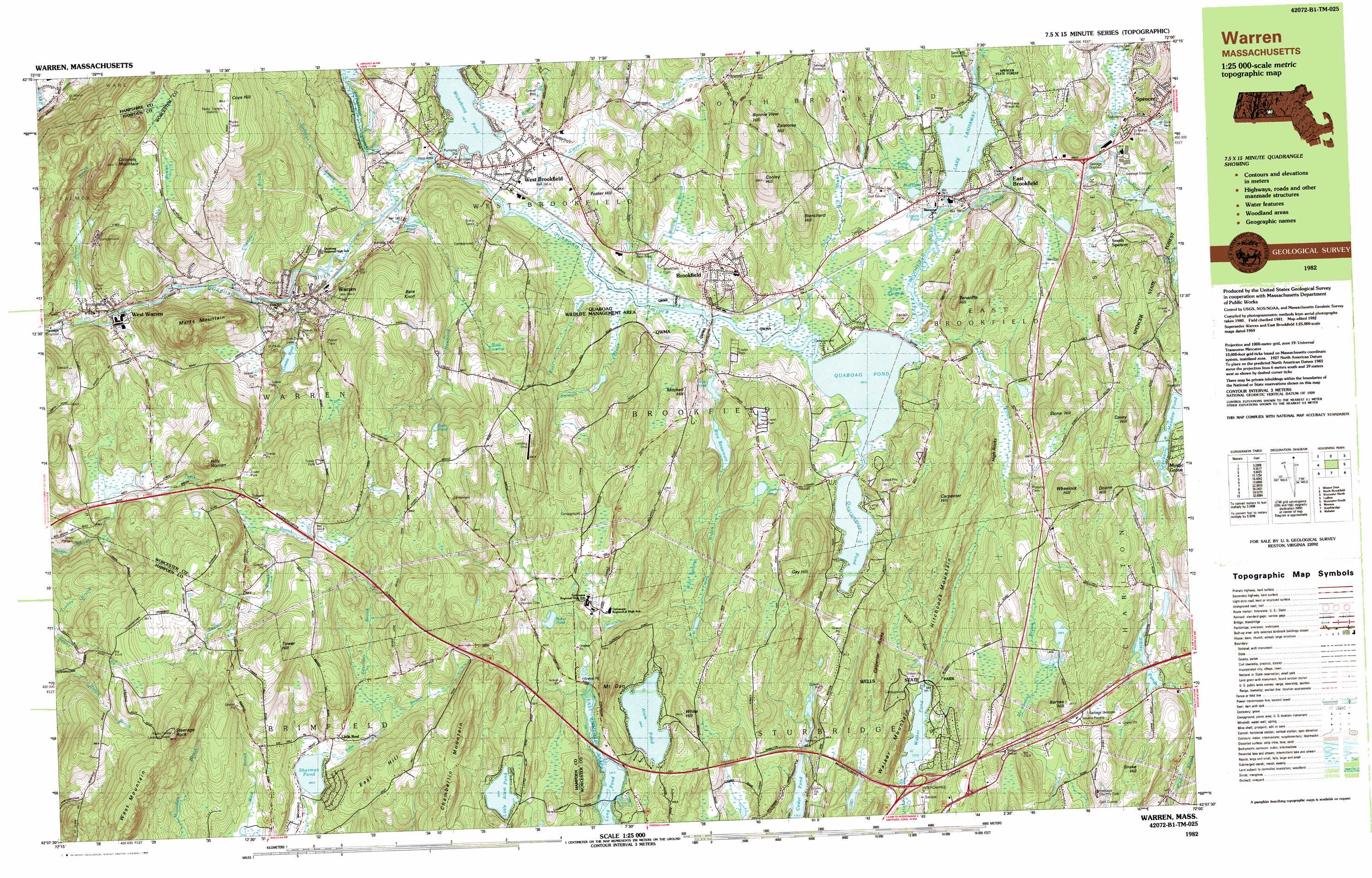
USGS Topo Quad 42072b1 - 1:25,000 scale
| Topo Map Name: | East Brookfield |
| USGS Topo Quad ID: | 42072b1 |
| Print Size: | ca. 39" wide x 24" high |
| Southeast Coordinates: | 42.125° N latitude / 72° W longitude |
| Map Center Coordinates: | 42.1875° N latitude / 72.125° W longitude |
| U.S. State: | MA |
| Filename: | k42072b1.jpg |
| Download Map JPG Image: | East Brookfield topo map 1:25,000 scale |
| Map Type: | Topographic |
| Topo Series: | 7.5´x15´ |
| Map Scale: | 1:25,000 |
| Source of Map Images: | United States Geological Survey (USGS) |
| Alternate Map Versions: |
Warren MA 1982, updated 1984 Download PDF Buy paper map Warren MA 1982, updated 1984 Download PDF Buy paper map |
1:24,000 Topo Quads surrounding East Brookfield
Quabbin Reservoir |
Barre |
Sterling |
||
Winsor Dam |
North Brookfield |
Worcester North |
||
Palmer |
East Brookfield |
Worcester South |
||
Monson |
Southbridge |
Oxford |
||
Stafford Springs |
Westford |
Eastford |
Putnam |
Thompson |
> Back to 42072a1 at 1:100,000 scale
> Back to 42072a1 at 1:250,000 scale
> Back to U.S. Topo Maps home
East Brookfield topo map: Gazetteer
East Brookfield: Airports
Pasport Airport elevation 307m 1007′East Brookfield: Dams
Alum Pond Dam elevation 226m 741′Ashworth Dam elevation 208m 682′
Beaudry Pond Dam elevation 186m 610′
Buxton Hill Pond Dam elevation 253m 830′
Comins Pond Dam elevation 190m 623′
Cranberry Meadow Pond Dam elevation 232m 761′
Fish Pond Dam C elevation 195m 639′
Howe Pond Dam elevation 207m 679′
Lake Lashaway Dam elevation 188m 616′
Lamberton Brook Dam elevation 191m 626′
Lower Sibley Pond Dam elevation 206m 675′
Saw Mill Pond Dam elevation 188m 616′
Shephard Pond Dam elevation 245m 803′
W D Cheney Dam elevation 214m 702′
West Warren Mill Pond Dam elevation 160m 524′
East Brookfield: Lakes
Claypit Pond elevation 188m 616′Cranberry Pond elevation 238m 780′
Earle Pond elevation 282m 925′
Howe Pond elevation 207m 679′
Little Alum Pond elevation 234m 767′
Long Pond elevation 192m 629′
Mud Pond elevation 192m 629′
Perry Pond elevation 191m 626′
Quaboag Pond elevation 182m 597′
Quacumquasit Pond elevation 182m 597′
Sherman Pond elevation 202m 662′
Walker Pond elevation 177m 580′
Wickaboag Pond elevation 182m 597′
East Brookfield: Parks
Brookfield Common Historic District elevation 216m 708′Dean Park elevation 165m 541′
Elm Hill Farm Historic District elevation 242m 793′
Mall Common elevation 209m 685′
Wells State Park elevation 220m 721′
West Brookfield Center Historic District elevation 191m 626′
East Brookfield: Populated Places
Brookfield elevation 219m 718′Brookfield Mobile Home Park elevation 222m 728′
East Brookfield elevation 187m 613′
Little Rest elevation 213m 698′
Marks Garrison elevation 192m 629′
Mystic Grove elevation 240m 787′
Nonatomqua Mobile Home Park elevation 195m 639′
South Spencer elevation 210m 688′
Union Chapel elevation 228m 748′
Warren elevation 193m 633′
West Brookfield elevation 191m 626′
West Warren elevation 170m 557′
East Brookfield: Reservoirs
Alum Pond elevation 226m 741′Baker Pond elevation 214m 702′
Beaudry Pond elevation 186m 610′
Comins Pond elevation 190m 623′
Cranberry Meadow Pond elevation 232m 761′
Fish Pond elevation 195m 639′
Lake Lashaway elevation 188m 616′
Lamberton Brook Reservoir elevation 191m 626′
Lower Sibley Pond elevation 206m 675′
Quoboag River Reservoir elevation 160m 524′
Rice Pond elevation 188m 616′
Rice Reservoir elevation 191m 626′
Shephard Pond elevation 245m 803′
Sibley Ponds elevation 207m 679′
Upper Sibley Pond elevation 208m 682′
East Brookfield: Ridges
Carpenter Rocks elevation 254m 833′High Rocks elevation 201m 659′
Hitchcock Mountain elevation 220m 721′
East Brookfield: Streams
Bradish Brook elevation 182m 597′Burr Brook elevation 183m 600′
Cheney Brook elevation 176m 577′
Coys Brook elevation 183m 600′
Cranberry River elevation 194m 636′
Dunn Brook elevation 183m 600′
East Brookfield River elevation 183m 600′
Fivemile River elevation 187m 613′
Forget-me-not Brook elevation 200m 656′
Great Brook elevation 183m 600′
Lamberton Brook elevation 183m 600′
Mill Brook elevation 184m 603′
Naultaug Brook elevation 183m 600′
O'Neil Brook elevation 174m 570′
Salmon Brook elevation 183m 600′
School Street Brook elevation 153m 501′
Sessions Brook elevation 212m 695′
Sevenmile River elevation 185m 606′
Sullivan Brook elevation 193m 633′
Taylor Brook elevation 236m 774′
Trout Brook elevation 183m 600′
Tufts Brook elevation 186m 610′
Willow Brook elevation 183m 600′
East Brookfield: Summits
Bare Hill elevation 268m 879′Bare Knoll elevation 294m 964′
Barnes Hill elevation 267m 875′
Blanchard Hill elevation 242m 793′
Bonnie View Hill elevation 283m 928′
Carpenter Hill elevation 274m 898′
Casey Hill elevation 303m 994′
Chamberlin Mountain elevation 258m 846′
Colonels Mountain elevation 362m 1187′
Cooley Hill elevation 294m 964′
Coys Hill elevation 356m 1167′
Doane Hill elevation 310m 1017′
East Hill elevation 250m 820′
Foster Hill elevation 235m 770′
Gay Hill elevation 271m 889′
Long Hill elevation 284m 931′
Marks Mountain elevation 331m 1085′
Mitchell Hill elevation 244m 800′
Mount Dan elevation 289m 948′
Snake Hill elevation 263m 862′
Steerage Rock elevation 367m 1204′
Stone Hill elevation 264m 866′
Teneriffe Hill elevation 259m 849′
Tower Hill elevation 336m 1102′
Walker Mountain elevation 256m 839′
West Mountain elevation 293m 961′
Wheelock Hill elevation 294m 964′
White Hill elevation 257m 843′
Zalatores Hill elevation 278m 912′
East Brookfield: Swamps
Allen Swamp elevation 183m 600′Ball Swamp elevation 250m 820′
Great Swamp elevation 183m 600′
Morgans Pond elevation 212m 695′
Wolf Swamp elevation 212m 695′
East Brookfield digital topo map on disk
Buy this East Brookfield topo map showing relief, roads, GPS coordinates and other geographical features, as a high-resolution digital map file on DVD:
New York, Vermont, Connecticut & Western Massachusetts
Buy digital topo maps: New York, Vermont, Connecticut & Western Massachusetts