Winsor Dam Topo Map Massachusetts
To zoom in, hover over the map of Winsor Dam
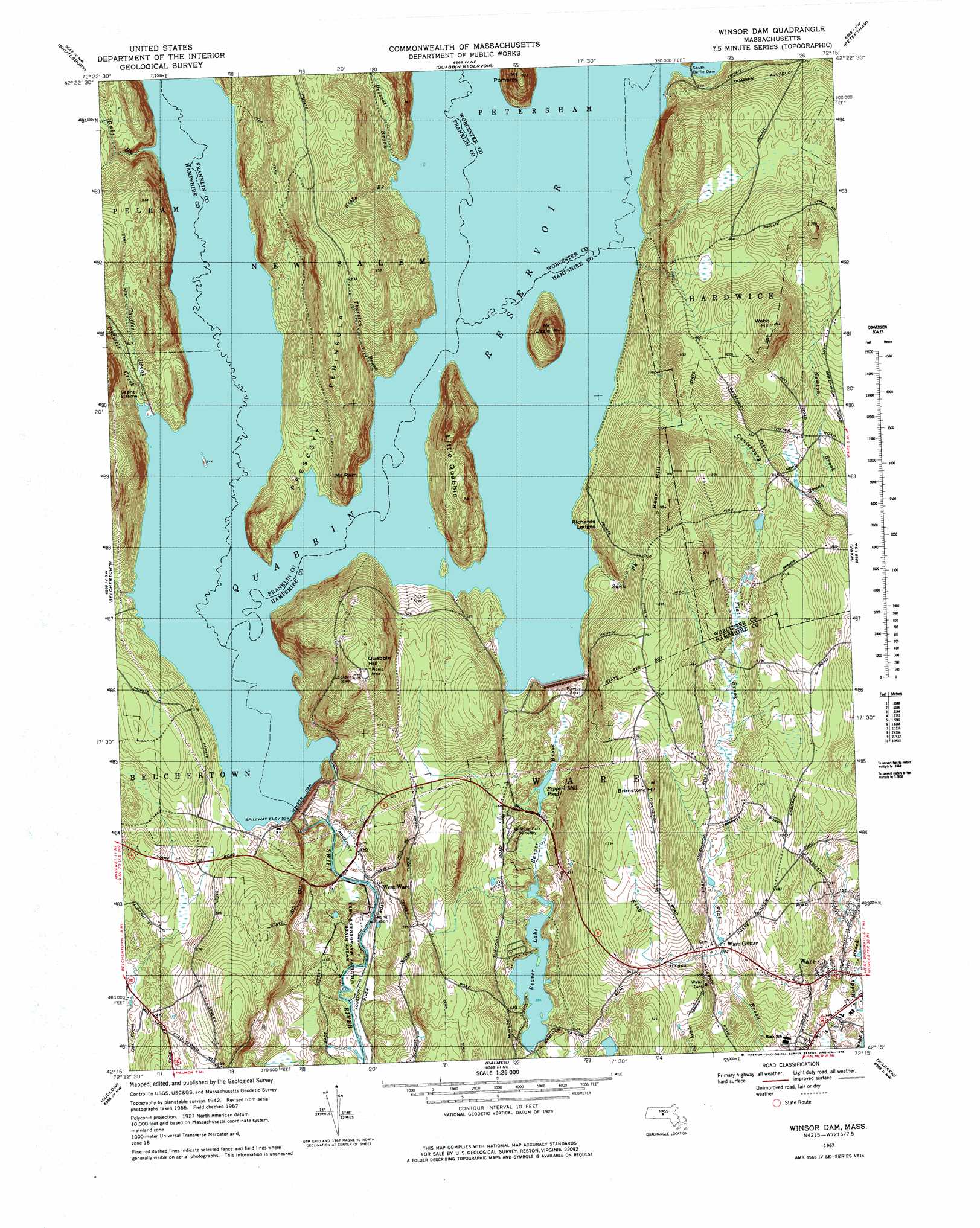
USGS Topo Quad 42072c3 - 1:25,000 scale
| Topo Map Name: | Winsor Dam |
| USGS Topo Quad ID: | 42072c3 |
| Print Size: | ca. 21 1/4" wide x 27" high |
| Southeast Coordinates: | 42.25° N latitude / 72.25° W longitude |
| Map Center Coordinates: | 42.3125° N latitude / 72.3125° W longitude |
| U.S. State: | MA |
| Filename: | l42072c3.jpg |
| Download Map JPG Image: | Winsor Dam topo map 1:25,000 scale |
| Map Type: | Topographic |
| Topo Series: | 7.5´ |
| Map Scale: | 1:25,000 |
| Source of Map Images: | United States Geological Survey (USGS) |
| Alternate Map Versions: |
Winsor Dam MA 1967, updated 1978 Download PDF Buy paper map Winsor Dam MA 1975, updated 1981 Download PDF Buy paper map |
1:24,000 Topo Quads surrounding Winsor Dam
Greenfield |
Orange |
Templeton |
||
Mount Toby |
Quabbin Reservoir |
Barre |
||
Mount Holyoke |
Belchertown |
Winsor Dam |
North Brookfield |
|
Springfield North |
Ludlow |
Palmer |
East Brookfield |
|
Springfield South |
Hampden |
Monson |
Southbridge |
> Back to 42072a1 at 1:100,000 scale
> Back to 42072a1 at 1:250,000 scale
> Back to U.S. Topo Maps home
Winsor Dam topo map: Gazetteer
Winsor Dam: Airports
Beaver Lake Seaplane Base elevation 117m 383′Winsor Dam: Bridges
Calvin Coolidge Bridge elevation 160m 524′Winsor Dam: Dams
Beaver Lake Dam elevation 122m 400′Goodnough Dike elevation 159m 521′
Juda Dam elevation 217m 711′
Peppers Mill Pond Dam elevation 122m 400′
Pilchs Number Three Dam elevation 156m 511′
Quabbin Spillway elevation 161m 528′
South Baffle Dam elevation 161m 528′
Winsor Dam elevation 144m 472′
Winsor Dam: Islands
Little Quabbin Island elevation 225m 738′Winsor Dam: Lakes
Davis Pond elevation 160m 524′East Pond elevation 160m 524′
Flask Pond elevation 160m 524′
Morton Pond elevation 160m 524′
Sunk Pond elevation 160m 524′
Winsor Dam: Parks
Quabbin Quabbin Park elevation 169m 554′Swift River Wildlife Management Area elevation 115m 377′
Ware Center Historic District elevation 154m 505′
Winsor Dam: Populated Places
Enfield (historical) elevation 160m 524′Greenwich (historical) elevation 160m 524′
Smiths (historical) elevation 160m 524′
Ware Center elevation 154m 505′
West Ware elevation 135m 442′
Winsor Dam: Post Offices
Ware Post Office elevation 124m 406′Winsor Dam: Reservoirs
Beaver Lake elevation 117m 383′Peppers Mill Pond elevation 126m 413′
Quabbin Reservoir elevation 144m 472′
Winsor Dam: Streams
Cadwell Creek elevation 161m 528′Canterbury Brook elevation 157m 515′
Chaffee Brook elevation 160m 524′
East Branch Swift River elevation 160m 524′
Gibbs Brook elevation 166m 544′
Gulf Brook elevation 160m 524′
King Brook elevation 152m 498′
Middle Branch Swift River elevation 160m 524′
Prescott Brook elevation 160m 524′
Sunk Brook elevation 166m 544′
Sunk Brook elevation 160m 524′
Thurston Brook elevation 160m 524′
West Branch Swift River elevation 160m 524′
Winsor Dam: Summits
Bear Hill elevation 301m 987′Brimstone Hill elevation 224m 734′
Little Quabbin elevation 266m 872′
Mount Lizzie elevation 256m 839′
Mount Ram elevation 250m 820′
Quabbin Hill elevation 306m 1003′
Richards Ledges elevation 166m 544′
Webb Hill elevation 324m 1062′
Winsor Dam digital topo map on disk
Buy this Winsor Dam topo map showing relief, roads, GPS coordinates and other geographical features, as a high-resolution digital map file on DVD:
New York, Vermont, Connecticut & Western Massachusetts
Buy digital topo maps: New York, Vermont, Connecticut & Western Massachusetts