Westhampton Topo Map Massachusetts
To zoom in, hover over the map of Westhampton
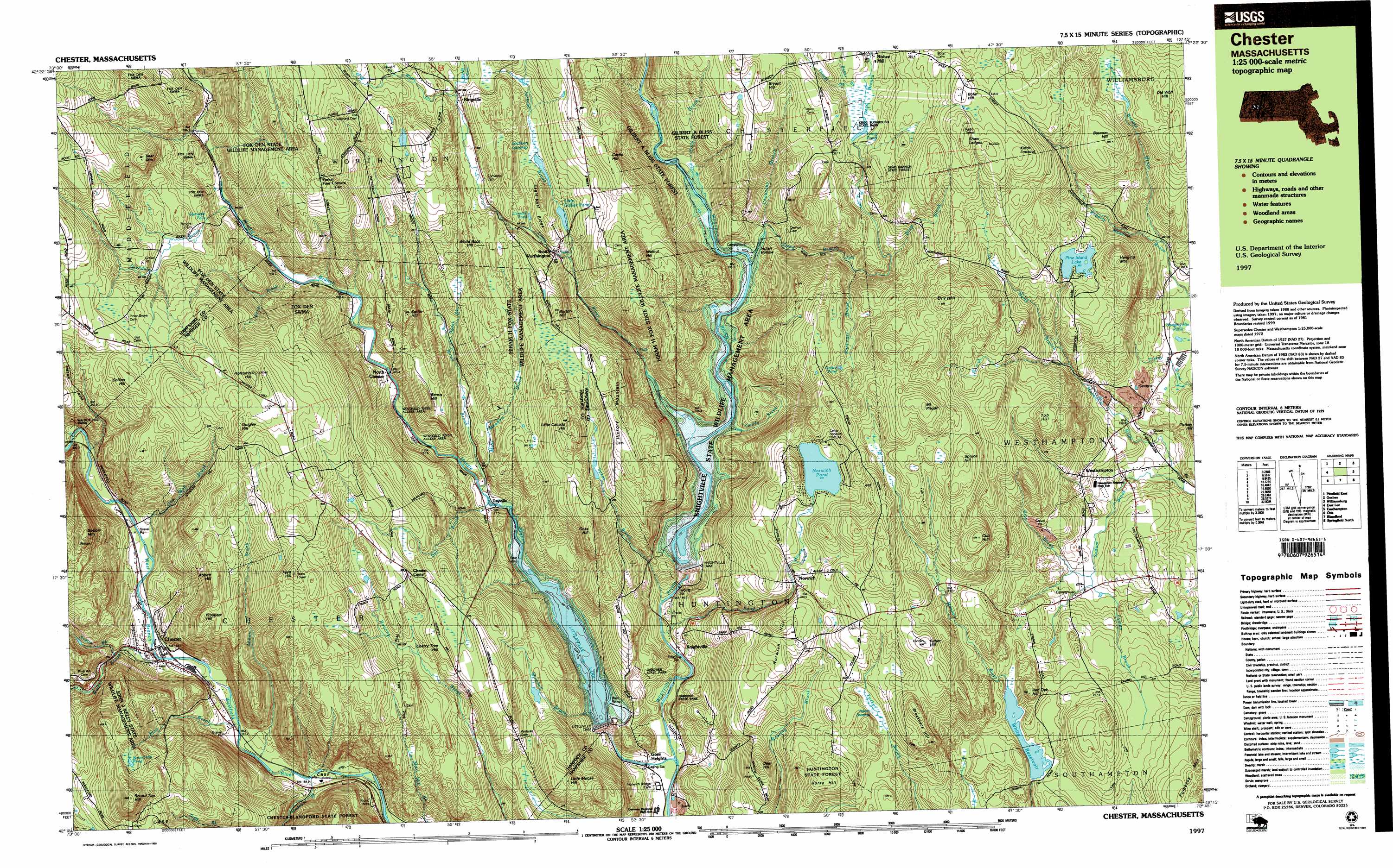
USGS Topo Quad 42072c7 - 1:25,000 scale
| Topo Map Name: | Westhampton |
| USGS Topo Quad ID: | 42072c7 |
| Print Size: | ca. 39" wide x 24" high |
| Southeast Coordinates: | 42.25° N latitude / 72.75° W longitude |
| Map Center Coordinates: | 42.3125° N latitude / 72.875° W longitude |
| U.S. State: | MA |
| Filename: | k42072c7.jpg |
| Download Map JPG Image: | Westhampton topo map 1:25,000 scale |
| Map Type: | Topographic |
| Topo Series: | 7.5´x15´ |
| Map Scale: | 1:25,000 |
| Source of Map Images: | United States Geological Survey (USGS) |
| Alternate Map Versions: |
Chester MA 1987, updated 1987 Download PDF Buy paper map Chester MA 1987, updated 1987 Download PDF Buy paper map Chester MA 1997, updated 1999 Download PDF Buy paper map |
1:24,000 Topo Quads surrounding Westhampton
Windsor |
Ashfield |
Greenfield |
||
Peru |
Goshen |
Mount Toby |
||
Becket |
Westhampton |
Easthampton |
Mount Holyoke |
|
Otis |
Woronoco |
Mount Tom |
Springfield North |
|
Tolland Center |
Southwick |
West Springfield |
Springfield South |
> Back to 42072a1 at 1:100,000 scale
> Back to 42072a1 at 1:250,000 scale
> Back to U.S. Topo Maps home
Westhampton topo map: Gazetteer
Westhampton: Dams
Knightville Dam elevation 164m 538′Littleville Dam elevation 156m 511′
Pine Island Lake Dam elevation 305m 1000′
White Reservoir Dam elevation 227m 744′
Westhampton: Falls
Glendale Falls elevation 306m 1003′Westhampton: Forests
Huntington State Forest elevation 342m 1122′Westhampton: Lakes
Conwell Pond elevation 302m 990′Grotto Pond elevation 364m 1194′
Hanging Mountain Pond elevation 163m 534′
Long Pond elevation 331m 1085′
Round Hill Pond elevation 421m 1381′
Westhampton: Parks
Chester Center Historic District elevation 380m 1246′Chester Factory Village Historic District elevation 181m 593′
Chester Wildlife Management Area elevation 290m 951′
Gardner State Park elevation 134m 439′
Westhampton: Populated Places
Bisbee Mill elevation 335m 1099′Chester elevation 180m 590′
Chester Center elevation 382m 1253′
Dayville elevation 177m 580′
Goss Heights elevation 187m 613′
Knightville elevation 151m 495′
Littleville elevation 158m 518′
North Chester elevation 204m 669′
Norwich elevation 333m 1092′
Ringville elevation 345m 1131′
South Worthington elevation 290m 951′
Westhampton elevation 190m 623′
Westhampton: Post Offices
Chester Post Office elevation 178m 583′Westhampton: Ranges
Bryant Hill elevation 407m 1335′Westhampton: Reservoirs
Knightville Reservoir elevation 185m 606′Little Gallilee Pond elevation 291m 954′
Littleville Lake elevation 156m 511′
Norwich Pond elevation 340m 1115′
Pine Island Lake elevation 305m 1000′
White Reservoir elevation 217m 711′
Westhampton: Ridges
Eagle Nest Ridge elevation 361m 1184′Westhampton: Streams
Abbott Brook elevation 160m 524′Austin Brook elevation 199m 652′
Baker Brook elevation 332m 1089′
Blair Brook elevation 166m 544′
Brewer Brook elevation 192m 629′
Chauncey Brook elevation 193m 633′
Day Brook elevation 174m 570′
Dead Branch elevation 174m 570′
Eastmans Brook elevation 346m 1135′
Florida Brook elevation 195m 639′
Glendale Brook elevation 245m 803′
Holly Brook elevation 189m 620′
Jackson Brook elevation 260m 853′
Kinne Brook elevation 179m 587′
Little River elevation 162m 531′
Lyman Brook elevation 172m 564′
Middle Branch Westfield River elevation 125m 410′
Moss Meadow Brook elevation 194m 636′
Otis Wait Brook elevation 198m 649′
Pittsinger Brook elevation 258m 846′
Pond Brook elevation 137m 449′
Rice Brook elevation 171m 561′
Sanderson Brook elevation 155m 508′
Shop Brook elevation 302m 990′
Skunk Brook elevation 219m 718′
Smith Brook elevation 231m 757′
Sodom Brook elevation 129m 423′
Still Brook elevation 166m 544′
Sykes Brook elevation 143m 469′
Thayer Brook elevation 332m 1089′
Walker Brook elevation 179m 587′
Wards Stream elevation 340m 1115′
Watts Stream elevation 336m 1102′
Winchell Brook elevation 158m 518′
Westhampton: Summits
Abbott Hill elevation 435m 1427′Bascom Hill elevation 375m 1230′
Bemis Hill elevation 342m 1122′
Bofat Hill elevation 434m 1423′
Breakneck Hill elevation 372m 1220′
Burton Hill elevation 379m 1243′
Castle Hill elevation 399m 1309′
Cherry Tree Hill elevation 369m 1210′
Collins Hill elevation 454m 1489′
Cub Hill elevation 424m 1391′
Deer Hill elevation 337m 1105′
Dry Hill elevation 454m 1489′
Fays Hill elevation 488m 1601′
Fisher Hill elevation 400m 1312′
Gobble Mountain elevation 504m 1653′
Goss Hill elevation 391m 1282′
Hanging Mountain elevation 361m 1184′
Hickory Mountain elevation 390m 1279′
Holcomb Hill elevation 525m 1722′
Horse Hill elevation 318m 1043′
Kidds Lookout elevation 438m 1437′
Little Canada Hill elevation 406m 1332′
Little Moose Hill elevation 367m 1204′
Mount Pisgah elevation 468m 1535′
Mud Hill elevation 324m 1062′
Norwich Hill elevation 361m 1184′
Old Wolf Hill elevation 371m 1217′
Red Oak Hill elevation 293m 961′
Round Top Hill elevation 538m 1765′
Shaw Ledges elevation 460m 1509′
Smith Hill elevation 366m 1200′
Spruce Hill elevation 438m 1437′
Tob Hill elevation 373m 1223′
Walnut Hill elevation 419m 1374′
White Rock Hill elevation 362m 1187′
Westhampton: Swamps
Adam Swamp elevation 301m 987′Jackson Swamp elevation 326m 1069′
Westhampton: Trails
Spring Trail elevation 375m 1230′Westhampton: Valleys
Indian Hollow elevation 188m 616′Westhampton digital topo map on disk
Buy this Westhampton topo map showing relief, roads, GPS coordinates and other geographical features, as a high-resolution digital map file on DVD:
New York, Vermont, Connecticut & Western Massachusetts
Buy digital topo maps: New York, Vermont, Connecticut & Western Massachusetts