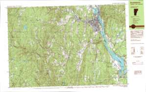
Brattleboro Topo Map Vermont
To zoom in, hover over the map of Brattleboro
USGS Topo Quad 42072g5 - 1:25,000 scale
| Topo Map Name: | Brattleboro |
| USGS Topo Quad ID: | 42072g5 |
| Print Size: | ca. 39" wide x 24" high |
| Southeast Coordinates: | 42.75° N latitude / 72.5° W longitude |
| Map Center Coordinates: | 42.8125° N latitude / 72.625° W longitude |
| U.S. States: | VT, NH |
| Filename: | k42072g5.jpg |
| Download Map JPG Image: | Brattleboro topo map 1:25,000 scale |
| Map Type: | Topographic |
| Topo Series: | 7.5´x15´ |
| Map Scale: | 1:25,000 |
| Source of Map Images: | United States Geological Survey (USGS) |
| Alternate Map Versions: |
Brattleboro VT 1984, updated 1984 Download PDF Buy paper map Brattleboro VT 1984, updated 1984 Download PDF Buy paper map |
1:24,000 Topo Quads surrounding Brattleboro
Jamaica |
Westminster West |
Gilsum |
||
West Dover |
Putney |
Keene |
||
Jacksonville |
Brattleboro |
West Swanzey |
||
Heath |
Bernardston |
Mount Grace |
||
Ashfield |
Greenfield |
Orange |
> Back to 42072e1 at 1:100,000 scale
> Back to 42072a1 at 1:250,000 scale
> Back to U.S. Topo Maps home
Brattleboro topo map: Gazetteer
Brattleboro: Benches
Mine Ledge elevation 399m 1309′Brattleboro: Bridges
Creamery Covered Bridge elevation 123m 403′Green River Covered Bridge elevation 215m 705′
Brattleboro: Crossings
Interchange 1 elevation 69m 226′Interchange 2 elevation 140m 459′
Brattleboro: Dams
Deer Park Pond Dam elevation 463m 1519′Sweet Pond Dam elevation 309m 1013′
Vernon Dam elevation 66m 216′
Vernon Dam elevation 66m 216′
Brattleboro: Islands
Stebbins Island elevation 68m 223′Brattleboro: Lakes
Indian Pond elevation 280m 918′South Pond elevation 505m 1656′
Sweet Pond elevation 295m 967′
Brattleboro: Parks
Brattleboro Downtown Historic District elevation 86m 282′Cromwell Park elevation 122m 400′
Eden Park elevation 128m 419′
Fort Dummer Monument elevation 126m 413′
Fort Dummer State Park elevation 194m 636′
Hinsdale Raceway elevation 81m 265′
Living Memorial Park elevation 154m 505′
Sweet Pond State Park elevation 291m 954′
The Common elevation 92m 301′
The Old Muster Ground elevation 537m 1761′
Whetsone Park elevation 96m 314′
Brattleboro: Populated Places
Algiers (historical) elevation 155m 508′Ames Hill elevation 532m 1745′
Brattleboro elevation 67m 219′
Fairview Village elevation 129m 423′
Green River elevation 215m 705′
Grove elevation 443m 1453′
Guilford elevation 135m 442′
Guilford Center elevation 216m 708′
Halifax elevation 481m 1578′
Harrisville elevation 416m 1364′
Marlboro elevation 531m 1742′
Mountain Home Trailer Park elevation 148m 485′
North Hinsdale elevation 119m 390′
North Vernon elevation 82m 269′
Reid Hollow elevation 373m 1223′
Vernon elevation 80m 262′
West Brattleboro elevation 147m 482′
West Guilford elevation 297m 974′
Whitneyville elevation 463m 1519′
Brattleboro: Post Offices
Brattleboro Post Office elevation 89m 291′Brattleboro: Reservoirs
Connecticut River Reservoir elevation 66m 216′Deer Park Pond elevation 463m 1519′
Sweets Pond elevation 309m 1013′
Brattleboro: Streams
Ames Hill Brook elevation 137m 449′Ash Swamp Brook elevation 66m 216′
Bell Brook elevation 95m 311′
Broad Brook elevation 66m 216′
Halladay Brook elevation 155m 508′
Harrisville Brook elevation 422m 1384′
Hinesburg Brook elevation 241m 790′
Lily Pond Brook elevation 104m 341′
Liscomb Brook elevation 68m 223′
Pond Brook elevation 378m 1240′
Sprague Brook elevation 68m 223′
West River elevation 66m 216′
Whetstone Brook elevation 66m 216′
Brattleboro: Summits
Central Mountain elevation 607m 1991′Chase Hill elevation 567m 1860′
Daniels Mountain elevation 371m 1217′
East Mountain elevation 416m 1364′
French Hill elevation 473m 1551′
Ginseng Hill elevation 459m 1505′
Governors Mountain elevation 497m 1630′
Jolly Mountain elevation 615m 2017′
Lyman Hill elevation 607m 1991′
Oak Hill elevation 132m 433′
Owls Head Mountain elevation 440m 1443′
Prospect Hill elevation 552m 1811′
Pulpit Mountain elevation 375m 1230′
Round Mountain elevation 441m 1446′
Stowe Mountain elevation 449m 1473′
Wantastiquet Mountain elevation 399m 1309′
Wilkens Hill elevation 392m 1286′
Brattleboro: Trails
Sunrise Trail elevation 194m 636′Sunset Trail elevation 191m 626′
Brattleboro: Valleys
Weatherhead Hollow elevation 140m 459′Brattleboro digital topo map on disk
Buy this Brattleboro topo map showing relief, roads, GPS coordinates and other geographical features, as a high-resolution digital map file on DVD:
New York, Vermont, Connecticut & Western Massachusetts
Buy digital topo maps: New York, Vermont, Connecticut & Western Massachusetts


