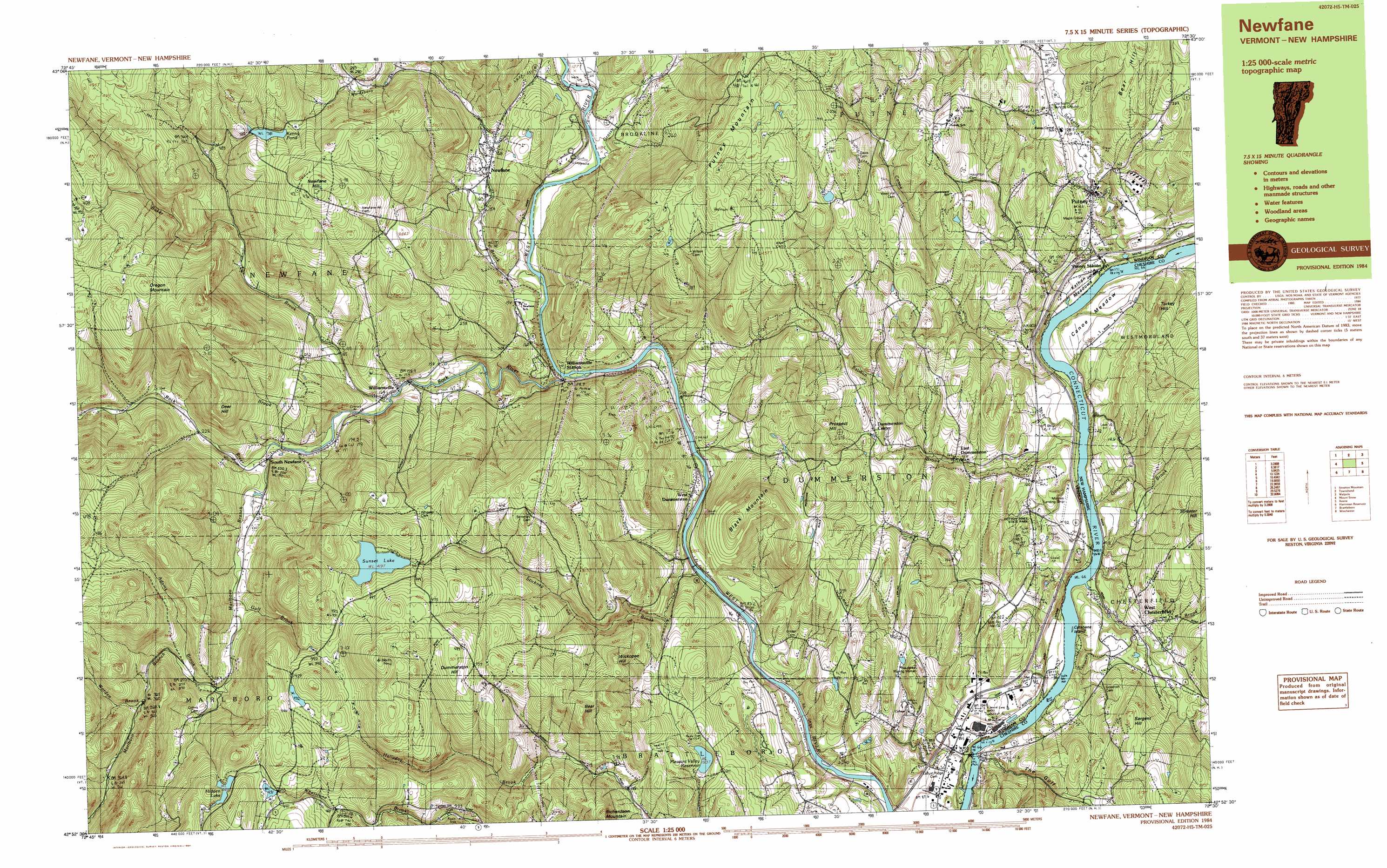
Putney Topo Map Vermont
To zoom in, hover over the map of Putney
USGS Topo Quad 42072h5 - 1:25,000 scale
| Topo Map Name: | Putney |
| USGS Topo Quad ID: | 42072h5 |
| Print Size: | ca. 39" wide x 24" high |
| Southeast Coordinates: | 42.875° N latitude / 72.5° W longitude |
| Map Center Coordinates: | 42.9375° N latitude / 72.625° W longitude |
| U.S. States: | VT, NH |
| Filename: | k42072h5.jpg |
| Download Map JPG Image: | Putney topo map 1:25,000 scale |
| Map Type: | Topographic |
| Topo Series: | 7.5´x15´ |
| Map Scale: | 1:25,000 |
| Source of Map Images: | United States Geological Survey (USGS) |
| Alternate Map Versions: |
Newfane VT 1984, updated 1984 Download PDF Buy paper map Newfane VT 1984, updated 1984 Download PDF Buy paper map |
1:24,000 Topo Quads surrounding Putney
Londonderry |
Saxtons River |
Alstead |
||
Jamaica |
Westminster West |
Gilsum |
||
West Dover |
Putney |
Keene |
||
Jacksonville |
Brattleboro |
West Swanzey |
||
Heath |
Bernardston |
Mount Grace |
> Back to 42072e1 at 1:100,000 scale
> Back to 42072a1 at 1:250,000 scale
> Back to U.S. Topo Maps home
Putney topo map: Gazetteer
Putney: Airports
Bobby Heliport elevation 124m 406′Moores Field elevation 92m 301′
Putney: Bridges
Sacketts Brook Stone Arch Bridge elevation 113m 370′West Dummerston Covered Bridge elevation 93m 305′
Williamsville Covered Bridge elevation 212m 695′
Putney: Crossings
Interchange 3 elevation 90m 295′Interchange 4 elevation 98m 321′
Putney: Dams
Goodrich Dam elevation 132m 433′Hidden Lake Dam elevation 449m 1473′
Kenny Pond Dam elevation 381m 1250′
Pleasant Valley Reservoir Dam elevation 193m 633′
Sunset Lake Dam elevation 419m 1374′
West Dummerston Dam elevation 108m 354′
Putney: Flats
Canoe Meadow elevation 83m 272′Kathan Meadows elevation 77m 252′
Putney: Forests
Putney Central School Forest elevation 120m 393′Putney: Islands
Catsbane Island elevation 66m 216′Putney: Parks
Dutton Pines State Forest Park elevation 120m 393′Newfane Village Historic District elevation 167m 547′
Putney: Populated Places
Dummerston Center elevation 231m 757′East Dummerston elevation 129m 423′
Newfane elevation 169m 554′
Putney elevation 114m 374′
South Newfane elevation 189m 620′
West Chesterfield elevation 111m 364′
West Dummerston elevation 132m 433′
Williamsville elevation 167m 547′
Williamsville Station elevation 115m 377′
Putney: Post Offices
Newfane Post Office elevation 184m 603′Putney Post Office elevation 115m 377′
Putney: Reservoirs
Hidden Lake elevation 449m 1473′Kenny Pond elevation 381m 1250′
Pleasant Valley Reservoir elevation 193m 633′
Sunset Lake elevation 419m 1374′
Putney: Streams
Adams Brook elevation 270m 885′Baker Brook elevation 160m 524′
Bellows Brook elevation 351m 1151′
Canoe Brook elevation 72m 236′
Catsbane Brook elevation 70m 229′
Fall Brook elevation 105m 344′
Governors Brook elevation 67m 219′
Grassy Brook elevation 119m 390′
Gulf Brook elevation 229m 751′
Joy Brook elevation 191m 626′
Marlboro Branch elevation 196m 643′
Mill Brook elevation 68m 223′
Pond Brook elevation 113m 370′
Rock River elevation 106m 347′
Sacketts Brook elevation 67m 219′
Salmon Brook elevation 71m 232′
Smith Brook elevation 114m 374′
Stickney Brook elevation 107m 351′
Worden Brook elevation 324m 1062′
Putney: Summits
Bear Hill elevation 402m 1318′Black Mountain elevation 367m 1204′
Deer Hill elevation 466m 1528′
Dummerston Hill elevation 499m 1637′
Newfane Hill elevation 490m 1607′
Oregon Mountain elevation 524m 1719′
Prospect Hill elevation 335m 1099′
Richardson Mountain elevation 365m 1197′
Sargent Hill elevation 266m 872′
Turkey Hill elevation 201m 659′
Wickopee Hill elevation 348m 1141′
Putney: Valleys
The Gulf elevation 70m 229′Putney digital topo map on disk
Buy this Putney topo map showing relief, roads, GPS coordinates and other geographical features, as a high-resolution digital map file on DVD:
New York, Vermont, Connecticut & Western Massachusetts
Buy digital topo maps: New York, Vermont, Connecticut & Western Massachusetts