Ashley Falls Topo Map Massachusetts
To zoom in, hover over the map of Ashley Falls
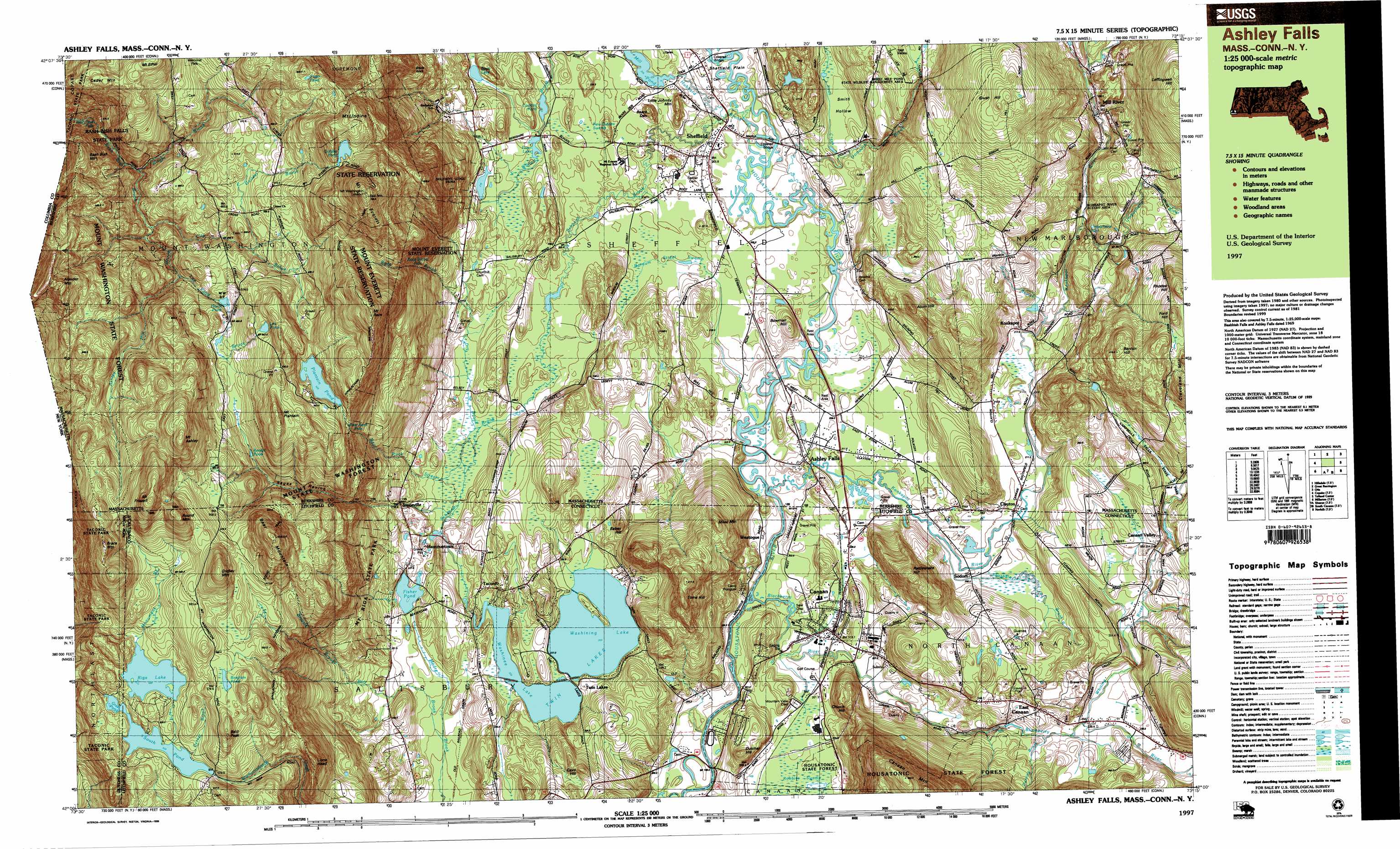
USGS Topo Quad 42073a3 - 1:25,000 scale
| Topo Map Name: | Ashley Falls |
| USGS Topo Quad ID: | 42073a3 |
| Print Size: | ca. 39" wide x 24" high |
| Southeast Coordinates: | 42° N latitude / 73.25° W longitude |
| Map Center Coordinates: | 42.0625° N latitude / 73.375° W longitude |
| U.S. States: | MA, CT |
| Filename: | k42073a3.jpg |
| Download Map JPG Image: | Ashley Falls topo map 1:25,000 scale |
| Map Type: | Topographic |
| Topo Series: | 7.5´x15´ |
| Map Scale: | 1:25,000 |
| Source of Map Images: | United States Geological Survey (USGS) |
| Alternate Map Versions: |
Ashley Falls MA 1987, updated 1987 Download PDF Buy paper map Ashley Falls MA 1987, updated 1987 Download PDF Buy paper map Ashley Falls MA 1997, updated 1999 Download PDF Buy paper map |
1:24,000 Topo Quads surrounding Ashley Falls
Chatham |
Stockbridge |
Becket |
||
Hillsdale |
Great Barrington |
Otis |
||
Copake |
Ashley Falls |
Tolland Center |
||
Millerton |
Sharon |
South Canaan |
Norfolk |
Winsted |
Amenia |
Ellsworth |
Cornwall |
West Torrington |
Torrington |
> Back to 42073a1 at 1:100,000 scale
> Back to 42072a1 at 1:250,000 scale
> Back to U.S. Topo Maps home
Ashley Falls topo map: Gazetteer
Ashley Falls: Airports
North Canaan Aviation Facilities Incorporated Airport elevation 202m 662′Ashley Falls: Bridges
Covered Bridge elevation 201m 659′Dutchers Bridge elevation 197m 646′
Old Covered Bridge elevation 201m 659′
Ashley Falls: Dams
Berkshire Trout Pond Dam elevation 214m 702′Combes Dam elevation 210m 688′
Fisher Pond Dam elevation 220m 721′
Garret Dam elevation 503m 1650′
Guilder Pond Dam elevation 625m 2050′
Mill Pond Dam elevation 205m 672′
Peyser Dam elevation 261m 856′
Plantain Pond Dam elevation 542m 1778′
Riga Lake Dam elevation 534m 1751′
South Pond Dam elevation 523m 1715′
Trout Pond Dam elevation 214m 702′
Twin Lakes Dam elevation 211m 692′
Whiting River Dam elevation 256m 839′
Ashley Falls: Falls
Bash Bish Falls elevation 345m 1131′Bear Rock Falls elevation 388m 1272′
Race Brook Falls elevation 380m 1246′
Umpachene Falls elevation 246m 807′
Ashley Falls: Flats
Sheffield Plain elevation 201m 659′Ashley Falls: Forests
Bashbish Falls State Forest (historical) elevation 348m 1141′Ashley Falls: Islands
Black Rock elevation 428m 1404′Mill River Cemetery elevation 275m 902′
Ashley Falls: Lakes
Becker Pond elevation 491m 1610′Bingham Pond elevation 577m 1893′
Fawn Lake elevation 211m 692′
Fisher Pond elevation 220m 721′
Grass Pond elevation 522m 1712′
Hunts Pond elevation 490m 1607′
Lee Pond elevation 545m 1788′
Riga Lake elevation 486m 1594′
Spurr Lake elevation 221m 725′
Twin Lakes elevation 224m 734′
Washinee Lake elevation 223m 731′
Washining Lake elevation 223m 731′
Yagar Pond elevation 598m 1961′
Ashley Falls: Parks
Bartholomews Cobble elevation 207m 679′Canaan Village Historic District elevation 207m 679′
Eddy Field elevation 209m 685′
Edith Scoville Memorial Sanctuary elevation 252m 826′
Lawrence FIeld elevation 203m 666′
Mount Riga State Park elevation 270m 885′
Sheffield Plain Historic District elevation 207m 679′
Ashley Falls: Populated Places
Alander elevation 558m 1830′Ashley Falls elevation 207m 679′
Canaan elevation 205m 672′
Canaan Valley elevation 258m 846′
Clayton elevation 229m 751′
East Canaan elevation 245m 803′
East Sheffield elevation 214m 702′
Foley (historical) elevation 237m 777′
Gomorrah elevation 210m 688′
Hammertown elevation 224m 734′
Joyceville elevation 239m 784′
Mill River elevation 257m 843′
Sheffield elevation 203m 666′
Sodom elevation 207m 679′
Taconic elevation 231m 757′
Twin Lakes elevation 225m 738′
Wangum Village elevation 198m 649′
Weatogue elevation 201m 659′
Ashley Falls: Post Offices
Alander Post Office (historical) elevation 506m 1660′Ashley Falls Post Office elevation 208m 682′
Canaan Post Office elevation 204m 669′
East Canaan Post Office elevation 243m 797′
Sheffield Post Office elevation 205m 672′
Ashley Falls: Reservoirs
Berkshire Trout Pond elevation 214m 702′Combes Pond elevation 210m 688′
Guilder Pond elevation 625m 2050′
Lee Pond Brook Reservoir elevation 503m 1650′
Mill Pond elevation 204m 669′
North Canaan Community Pool elevation 210m 688′
Plantain Pond elevation 523m 1715′
Riga Lake elevation 534m 1751′
South Pond elevation 522m 1712′
South Pond elevation 523m 1715′
Twin Lakes elevation 211m 692′
Whiting River Reservoir elevation 256m 839′
Ashley Falls: Streams
Ashley Hill Brook elevation 389m 1276′Ball Brook elevation 213m 698′
Bear Rock Stream elevation 207m 679′
Blackberry River elevation 196m 643′
Brassi Brook elevation 256m 839′
Brewer Brook elevation 216m 708′
City Brook elevation 389m 1276′
Decker Brook elevation 523m 1715′
Dry Brook elevation 207m 679′
Duming Brook elevation 225m 738′
Guilder Brook elevation 465m 1525′
Hubbard Brook elevation 201m 659′
Ironwork Brook elevation 198m 649′
Konkapot River elevation 196m 643′
Lee Pond Brook elevation 447m 1466′
Monument Brook elevation 533m 1748′
Race Brook elevation 217m 711′
Schenob Brook elevation 201m 659′
Soda Creek elevation 211m 692′
Squabble Brook elevation 207m 679′
Stony Brook elevation 207m 679′
Umpachene River elevation 228m 748′
Whiting River elevation 228m 748′
Wright Brook elevation 363m 1190′
Ashley Falls: Summits
Alum Hill elevation 330m 1082′Babes Hill elevation 296m 971′
Bald Peak elevation 588m 1929′
Bash Bish Mountain elevation 460m 1509′
Bear Mountain elevation 708m 2322′
Bears Den elevation 247m 810′
Benton Hill elevation 408m 1338′
Bowman Hill elevation 241m 790′
Brace Mountain elevation 706m 2316′
Brush Hill elevation 441m 1446′
Cave Hill elevation 313m 1026′
Cedar Mountain elevation 570m 1870′
Church Hill elevation 291m 954′
Dutcher Hill elevation 264m 866′
Ford Hill elevation 426m 1397′
Gridley Mountain elevation 668m 2191′
Lions Head elevation 517m 1696′
Little Johnny Mountain elevation 248m 813′
Miles Mountain elevation 356m 1167′
Mount Ashley elevation 725m 2378′
Mount Ethel elevation 588m 1929′
Mount Everett elevation 793m 2601′
Mount Frissell elevation 747m 2450′
Mount Plantain elevation 626m 2053′
Mount Race elevation 723m 2372′
Mount Undine elevation 669m 2194′
Mount Washington elevation 508m 1666′
Rattlesnake Hill elevation 354m 1161′
Rhodes Hill elevation 426m 1397′
Round Mountain elevation 695m 2280′
Toms Hill elevation 413m 1354′
Ashley Falls: Swamps
Barnum Street Swamp elevation 209m 685′New Guinea Swamp elevation 210m 688′
Ashley Falls: Trails
Elbow Trail elevation 389m 1276′Indian Trail elevation 570m 1870′
Northrop Trail elevation 560m 1837′
Ashley Falls: Valleys
Guilder Hollow elevation 519m 1702′Sages Ravine elevation 254m 833′
Sages Ravine elevation 261m 856′
Smith Hollow elevation 215m 705′
Ashley Falls digital topo map on disk
Buy this Ashley Falls topo map showing relief, roads, GPS coordinates and other geographical features, as a high-resolution digital map file on DVD:
New York, Vermont, Connecticut & Western Massachusetts
Buy digital topo maps: New York, Vermont, Connecticut & Western Massachusetts