Copake Topo Map New York
To zoom in, hover over the map of Copake
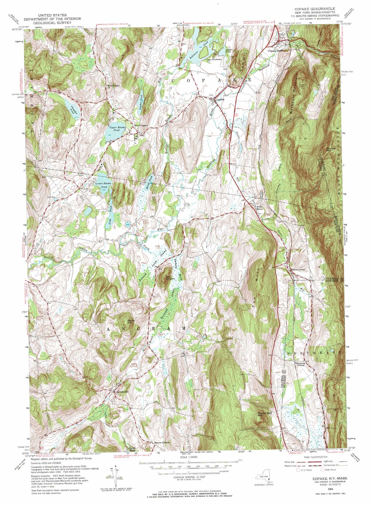
USGS Topo Quad 42073a5 - 1:24,000 scale
| Topo Map Name: | Copake |
| USGS Topo Quad ID: | 42073a5 |
| Print Size: | ca. 21 1/4" wide x 27" high |
| Southeast Coordinates: | 42° N latitude / 73.5° W longitude |
| Map Center Coordinates: | 42.0625° N latitude / 73.5625° W longitude |
| U.S. States: | NY, MA |
| Filename: | o42073a5.jpg |
| Download Map JPG Image: | Copake topo map 1:24,000 scale |
| Map Type: | Topographic |
| Topo Series: | 7.5´ |
| Map Scale: | 1:24,000 |
| Source of Map Images: | United States Geological Survey (USGS) |
| Alternate Map Versions: |
Copake NY 1953, updated 1955 Download PDF Buy paper map Copake NY 1953, updated 1965 Download PDF Buy paper map Copake NY 1953, updated 1971 Download PDF Buy paper map Copake NY 1953, updated 1984 Download PDF Buy paper map Copake NY 2010 Download PDF Buy paper map Copake NY 2013 Download PDF Buy paper map Copake NY 2016 Download PDF Buy paper map |
1:24,000 Topo Quads surrounding Copake
Hudson North |
Stottville |
Chatham |
Stockbridge |
|
Hudson South |
Claverack |
Hillsdale |
Great Barrington |
|
Clermont |
Ancram |
Copake |
Ashley Falls |
|
Rock City |
Pine Plains |
Millerton |
Sharon |
South Canaan |
Salt Point |
Millbrook |
Amenia |
Ellsworth |
Cornwall |
> Back to 42073a1 at 1:100,000 scale
> Back to 42072a1 at 1:250,000 scale
> Back to U.S. Topo Maps home
Copake topo map: Gazetteer
Copake: Lakes
Chrysler Pond elevation 176m 577′Long Pond elevation 152m 498′
Lower Rhoda Pond elevation 153m 501′
Miller Pond elevation 156m 511′
Robinson Pond elevation 162m 531′
Shaver Pond elevation 166m 544′
Snyder Pond elevation 163m 534′
Upper Rhoda Pond elevation 165m 541′
Copake: Parks
Taconic State Park elevation 393m 1289′Copake: Populated Places
Ancramdale elevation 167m 547′Boston Corner elevation 216m 708′
Copake elevation 166m 544′
Copake Falls elevation 196m 643′
Weed Mines elevation 185m 606′
West Copake elevation 169m 554′
Whitehouse Crossing elevation 230m 754′
Copake: Streams
Bash Bish Brook elevation 150m 492′Cedar Brook elevation 217m 711′
Cedar Brook elevation 219m 718′
Noster Kill elevation 162m 531′
Punch Brook elevation 149m 488′
Copake: Summits
Alander Mountain elevation 680m 2230′Fox Hill elevation 410m 1345′
Old Croken elevation 251m 823′
Round Ball Mountain elevation 401m 1315′
Smith Hill elevation 300m 984′
Tom Hill elevation 272m 892′
Washburn Mountain elevation 456m 1496′
Copake: Swamps
Drowned Lands Swamp elevation 152m 498′Copake: Valleys
Preechey Hollow elevation 182m 597′Copake digital topo map on disk
Buy this Copake topo map showing relief, roads, GPS coordinates and other geographical features, as a high-resolution digital map file on DVD:
New York, Vermont, Connecticut & Western Massachusetts
Buy digital topo maps: New York, Vermont, Connecticut & Western Massachusetts