Kinderhook Topo Map New York
To zoom in, hover over the map of Kinderhook
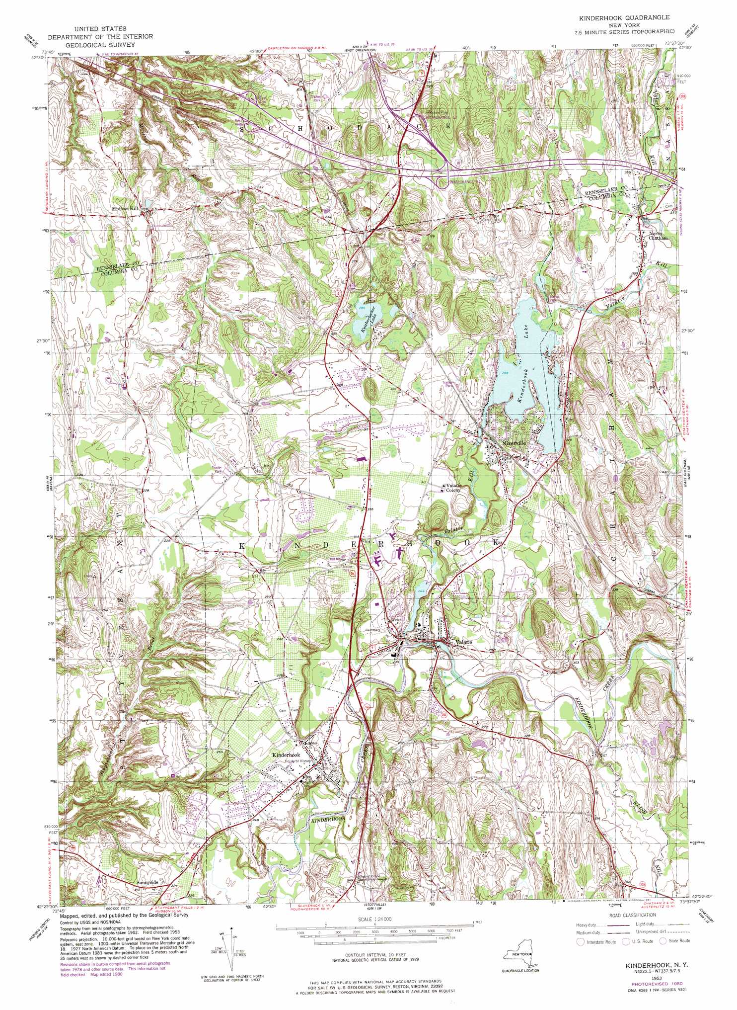
USGS Topo Quad 42073d6 - 1:24,000 scale
| Topo Map Name: | Kinderhook |
| USGS Topo Quad ID: | 42073d6 |
| Print Size: | ca. 21 1/4" wide x 27" high |
| Southeast Coordinates: | 42.375° N latitude / 73.625° W longitude |
| Map Center Coordinates: | 42.4375° N latitude / 73.6875° W longitude |
| U.S. State: | NY |
| Filename: | o42073d6.jpg |
| Download Map JPG Image: | Kinderhook topo map 1:24,000 scale |
| Map Type: | Topographic |
| Topo Series: | 7.5´ |
| Map Scale: | 1:24,000 |
| Source of Map Images: | United States Geological Survey (USGS) |
| Alternate Map Versions: |
Kinderhook NY 1953, updated 1955 Download PDF Buy paper map Kinderhook NY 1953, updated 1965 Download PDF Buy paper map Kinderhook NY 1980, updated 1981 Download PDF Buy paper map Kinderhook NY 2010 Download PDF Buy paper map Kinderhook NY 2013 Download PDF Buy paper map Kinderhook NY 2016 Download PDF Buy paper map |
1:24,000 Topo Quads surrounding Kinderhook
Voorheesville |
Albany |
Troy South |
Averill Park |
|
Clarksville |
Delmar |
East Greenbush |
Nassau |
|
Alcove |
Ravena |
Kinderhook |
East Chatham |
|
Leeds |
Hudson North |
Stottville |
Chatham |
|
Cementon |
Hudson South |
Claverack |
Hillsdale |
> Back to 42073a1 at 1:100,000 scale
> Back to 42072a1 at 1:250,000 scale
> Back to U.S. Topo Maps home
Kinderhook topo map: Gazetteer
Kinderhook: Lakes
Knickerbocker Lake elevation 87m 285′Kinderhook: Populated Places
Dwarf Orchard Park elevation 89m 291′Hanson Trailer Park elevation 70m 229′
Kinderhook elevation 77m 252′
Muitzes Kill elevation 77m 252′
Niverville elevation 97m 318′
North Chatham elevation 107m 351′
Stones Mobile Manor elevation 85m 278′
Sunnyside elevation 67m 219′
Valatie elevation 73m 239′
Valatie Colony elevation 96m 314′
Kinderhook: Reservoirs
Kinderhook Lake elevation 87m 285′Kinderhook: Streams
Kline Kill elevation 73m 239′Valatie Kill elevation 61m 200′
Kinderhook digital topo map on disk
Buy this Kinderhook topo map showing relief, roads, GPS coordinates and other geographical features, as a high-resolution digital map file on DVD:
New York, Vermont, Connecticut & Western Massachusetts
Buy digital topo maps: New York, Vermont, Connecticut & Western Massachusetts