Nassau Topo Map New York
To zoom in, hover over the map of Nassau
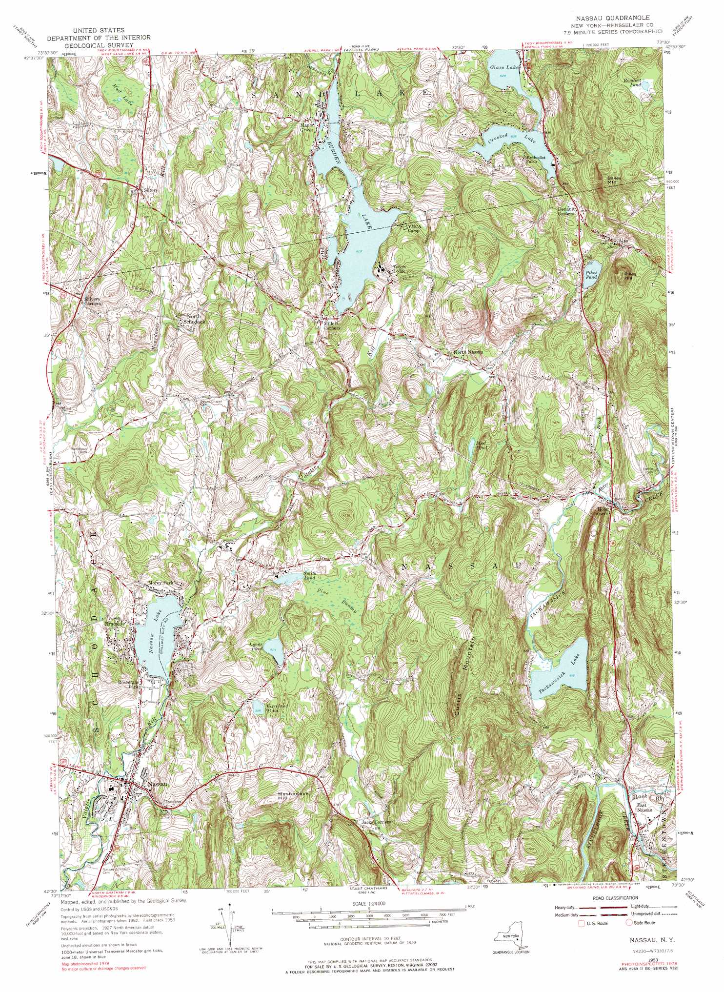
USGS Topo Quad 42073e5 - 1:24,000 scale
| Topo Map Name: | Nassau |
| USGS Topo Quad ID: | 42073e5 |
| Print Size: | ca. 21 1/4" wide x 27" high |
| Southeast Coordinates: | 42.5° N latitude / 73.5° W longitude |
| Map Center Coordinates: | 42.5625° N latitude / 73.5625° W longitude |
| U.S. State: | NY |
| Filename: | o42073e5.jpg |
| Download Map JPG Image: | Nassau topo map 1:24,000 scale |
| Map Type: | Topographic |
| Topo Series: | 7.5´ |
| Map Scale: | 1:24,000 |
| Source of Map Images: | United States Geological Survey (USGS) |
| Alternate Map Versions: |
Nassau NY 1953, updated 1955 Download PDF Buy paper map Nassau NY 1953, updated 1967 Download PDF Buy paper map Nassau NY 1953, updated 1979 Download PDF Buy paper map Nassau NY 1953, updated 1984 Download PDF Buy paper map Nassau NY 2010 Download PDF Buy paper map Nassau NY 2013 Download PDF Buy paper map Nassau NY 2016 Download PDF Buy paper map |
1:24,000 Topo Quads surrounding Nassau
Niskayuna |
Troy North |
Tomhannock |
Grafton |
North Pownal |
Albany |
Troy South |
Averill Park |
Berlin |
|
Delmar |
East Greenbush |
Nassau |
Hancock |
|
Ravena |
Kinderhook |
East Chatham |
Pittsfield West |
|
Hudson North |
Stottville |
Chatham |
Stockbridge |
> Back to 42073e1 at 1:100,000 scale
> Back to 42072a1 at 1:250,000 scale
> Back to U.S. Topo Maps home
Nassau topo map: Gazetteer
Nassau: Airports
Alexander Farm Airport elevation 154m 505′Nassau: Lakes
Burden Lake elevation 191m 626′Cleveland Pond elevation 178m 583′
Crooked Lake elevation 252m 826′
Glass Lake elevation 252m 826′
Lyons Pond elevation 190m 623′
Mud Lake elevation 188m 616′
Mud Pond elevation 215m 705′
Nassau Lake elevation 126m 413′
Pikes Pond elevation 242m 793′
Rendert Pond elevation 416m 1364′
Smith Pond elevation 172m 564′
Tackawasick Lake elevation 188m 616′
Nassau: Populated Places
Braeside elevation 128m 419′Cedar Acres Mobile Home Park elevation 142m 465′
Denault Corners elevation 266m 872′
East Nassau elevation 174m 570′
Hoag Corners elevation 212m 695′
Maple Grove elevation 195m 639′
Millers Corners elevation 199m 652′
Morey Park elevation 134m 439′
Nassau elevation 123m 403′
North Nassau elevation 199m 652′
North Schodack elevation 163m 534′
Rainbow Mobile Home Park elevation 129m 423′
Rosecrans Park elevation 128m 419′
Sliters elevation 181m 593′
Nassau: Streams
Alder Brook elevation 206m 675′Black Brook elevation 167m 547′
Tackawasick Creek elevation 161m 528′
Nassau: Summits
Bailey Mountain elevation 409m 1341′Curtis Mountain elevation 336m 1102′
Mashodack Hill elevation 265m 869′
Pikes Hill elevation 357m 1171′
Nassau: Swamps
Pine Swamp elevation 173m 567′Nassau digital topo map on disk
Buy this Nassau topo map showing relief, roads, GPS coordinates and other geographical features, as a high-resolution digital map file on DVD:
New York, Vermont, Connecticut & Western Massachusetts
Buy digital topo maps: New York, Vermont, Connecticut & Western Massachusetts