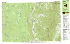
Berlin Topo Map New York
To zoom in, hover over the map of Berlin
USGS Topo Quad 42073f3 - 1:25,000 scale
| Topo Map Name: | Berlin |
| USGS Topo Quad ID: | 42073f3 |
| Print Size: | ca. 39" wide x 24" high |
| Southeast Coordinates: | 42.625° N latitude / 73.25° W longitude |
| Map Center Coordinates: | 42.6875° N latitude / 73.375° W longitude |
| U.S. States: | NY, MA, VT |
| Filename: | k42073f3.jpg |
| Download Map JPG Image: | Berlin topo map 1:25,000 scale |
| Map Type: | Topographic |
| Topo Series: | 7.5´x15´ |
| Map Scale: | 1:25,000 |
| Source of Map Images: | United States Geological Survey (USGS) |
| Alternate Map Versions: |
Berlin NY 1988, updated 1988 Download PDF Buy paper map Berlin NY 1998, updated 2001 Download PDF Buy paper map |
| FStopo: | US Forest Service topo Berlin is available: Download FStopo PDF Download FStopo TIF |
1:24,000 Topo Quads surrounding Berlin
Schaghticoke |
Eagle Bridge |
Hoosick Falls |
Bennington |
Woodford |
Tomhannock |
Grafton |
North Pownal |
Pownal |
Stamford |
Averill Park |
Berlin |
North Adams |
||
Nassau |
Hancock |
Windsor |
||
East Chatham |
Pittsfield West |
Peru |
> Back to 42073e1 at 1:100,000 scale
> Back to 42072a1 at 1:250,000 scale
> Back to U.S. Topo Maps home
Berlin topo map: Gazetteer
Berlin: Forests
Hopkins Memorial Forest elevation 397m 1302′Berlin: Gaps
Berlin Pass elevation 674m 2211′Petersburg Pass elevation 632m 2073′
Berlin: Lakes
Big Bowman Pond elevation 430m 1410′Bonesteel Pond elevation 390m 1279′
Cranberry Pond elevation 505m 1656′
Dyken Pond elevation 495m 1624′
Forest Lake elevation 475m 1558′
Gravel Pond elevation 435m 1427′
Hicks Pond elevation 368m 1207′
Hosford Pond elevation 412m 1351′
Kendall Pond elevation 530m 1738′
Little Bowman Pond elevation 431m 1414′
South Long Pond elevation 495m 1624′
Spring Lake elevation 538m 1765′
Taconic Pond elevation 499m 1637′
Berlin: Parks
Taconic Trail State Park elevation 451m 1479′Berlin: Populated Places
Berlin elevation 256m 839′Bucks Corner elevation 480m 1574′
Center Berlin elevation 294m 964′
Cherryplain elevation 346m 1135′
East Poestenkill elevation 331m 1085′
Petersburg elevation 217m 711′
Taborton elevation 435m 1427′
Berlin: Reservoirs
Round Pond elevation 534m 1751′Wager Pond elevation 420m 1377′
Berlin: Springs
Indian Spring elevation 324m 1062′Berlin: Streams
Cranberry Vly Creek elevation 432m 1417′Kronk Brook elevation 341m 1118′
North Branch Hemlock Brook elevation 321m 1053′
South Branch Hemlock Brook elevation 321m 1053′
Berlin: Summits
Berlin Mountain elevation 853m 2798′Berlin Mountain elevation 852m 2795′
Buck Rock elevation 562m 1843′
Mount Raimer elevation 784m 2572′
Perigo Hill elevation 571m 1873′
Rocky Hill elevation 625m 2050′
Smith Hill elevation 703m 2306′
Sugarloaf Hill elevation 423m 1387′
The Gipfel elevation 561m 1840′
The Snow Hole elevation 698m 2290′
White Rocks elevation 706m 2316′
Berlin: Trails
Southeast Hollow Trail elevation 473m 1551′Taconic Crest Trail elevation 741m 2431′
Williams Trail elevation 528m 1732′
Berlin: Valleys
Allen Hollow elevation 345m 1131′Browns Hollow elevation 318m 1043′
Comstock Hollow elevation 310m 1017′
Cowdry Hollow elevation 284m 931′
East Hollow elevation 276m 905′
East Hollow elevation 246m 807′
Green Brook Hollow elevation 300m 984′
Greene Hollow elevation 259m 849′
Jones Hollow elevation 206m 675′
Mattison Hollow elevation 341m 1118′
Mills Hollow elevation 430m 1410′
Satterlee Hollow elevation 255m 836′
Southeast Hollow elevation 266m 872′
The Notch elevation 467m 1532′
Berlin digital topo map on disk
Buy this Berlin topo map showing relief, roads, GPS coordinates and other geographical features, as a high-resolution digital map file on DVD:
New York, Vermont, Connecticut & Western Massachusetts
Buy digital topo maps: New York, Vermont, Connecticut & Western Massachusetts


