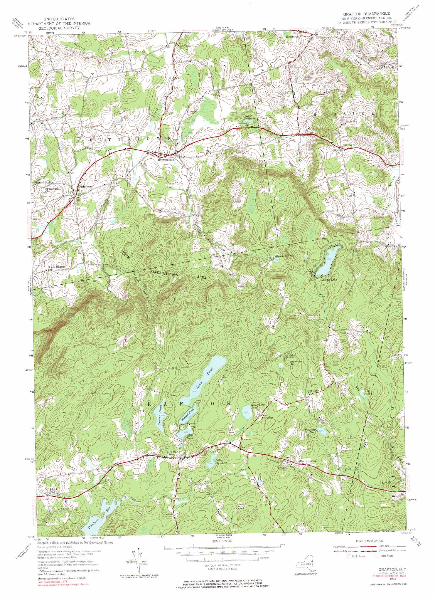
Grafton Topo Map New York
To zoom in, hover over the map of Grafton
USGS Topo Quad 42073g4 - 1:24,000 scale
| Topo Map Name: | Grafton |
| USGS Topo Quad ID: | 42073g4 |
| Print Size: | ca. 21 1/4" wide x 27" high |
| Southeast Coordinates: | 42.75° N latitude / 73.375° W longitude |
| Map Center Coordinates: | 42.8125° N latitude / 73.4375° W longitude |
| U.S. State: | NY |
| Filename: | o42073g4.jpg |
| Download Map JPG Image: | Grafton topo map 1:24,000 scale |
| Map Type: | Topographic |
| Topo Series: | 7.5´ |
| Map Scale: | 1:24,000 |
| Source of Map Images: | United States Geological Survey (USGS) |
| Alternate Map Versions: |
Grafton NY 1954, updated 1956 Download PDF Buy paper map Grafton NY 1954, updated 1964 Download PDF Buy paper map Grafton NY 1954, updated 1983 Download PDF Buy paper map Grafton NY 1978, updated 1983 Download PDF Buy paper map Grafton NY 2010 Download PDF Buy paper map Grafton NY 2013 Download PDF Buy paper map Grafton NY 2016 Download PDF Buy paper map |
1:24,000 Topo Quads surrounding Grafton
Quaker Springs |
Schuylerville |
Cambridge |
Shushan |
Arlington |
Mechanicville |
Schaghticoke |
Eagle Bridge |
Hoosick Falls |
Bennington |
Troy North |
Tomhannock |
Grafton |
North Pownal |
Pownal |
Troy South |
Averill Park |
Berlin |
||
East Greenbush |
Nassau |
Hancock |
> Back to 42073e1 at 1:100,000 scale
> Back to 42072a1 at 1:250,000 scale
> Back to U.S. Topo Maps home
Grafton topo map: Gazetteer
Grafton: Lakes
Banker Pond elevation 341m 1118′Lake Elizabeth elevation 446m 1463′
Lake Lorraine elevation 199m 652′
Long Pond elevation 457m 1499′
Peckham Pond elevation 451m 1479′
Red Pond elevation 417m 1368′
Second Pond elevation 454m 1489′
White Lily Pond elevation 476m 1561′
Grafton: Populated Places
Babcock Lake elevation 402m 1318′Boyntonville elevation 188m 616′
East Grafton elevation 468m 1535′
Factory Hollow elevation 166m 544′
Grafton elevation 449m 1473′
Pittstown elevation 173m 567′
Potter Hill elevation 273m 895′
Southwest Hoosick elevation 254m 833′
Grafton: Reservoirs
Dunham Reservoir elevation 402m 1318′Mill Pond elevation 450m 1476′
Shaver Pond elevation 447m 1466′
Grafton: Summits
Dickinson Hill elevation 537m 1761′Grafton: Valleys
Couch Hollow elevation 425m 1394′Ward Hollow elevation 168m 551′
Grafton digital topo map on disk
Buy this Grafton topo map showing relief, roads, GPS coordinates and other geographical features, as a high-resolution digital map file on DVD:
New York, Vermont, Connecticut & Western Massachusetts
Buy digital topo maps: New York, Vermont, Connecticut & Western Massachusetts