Troy North Topo Map New York
To zoom in, hover over the map of Troy North
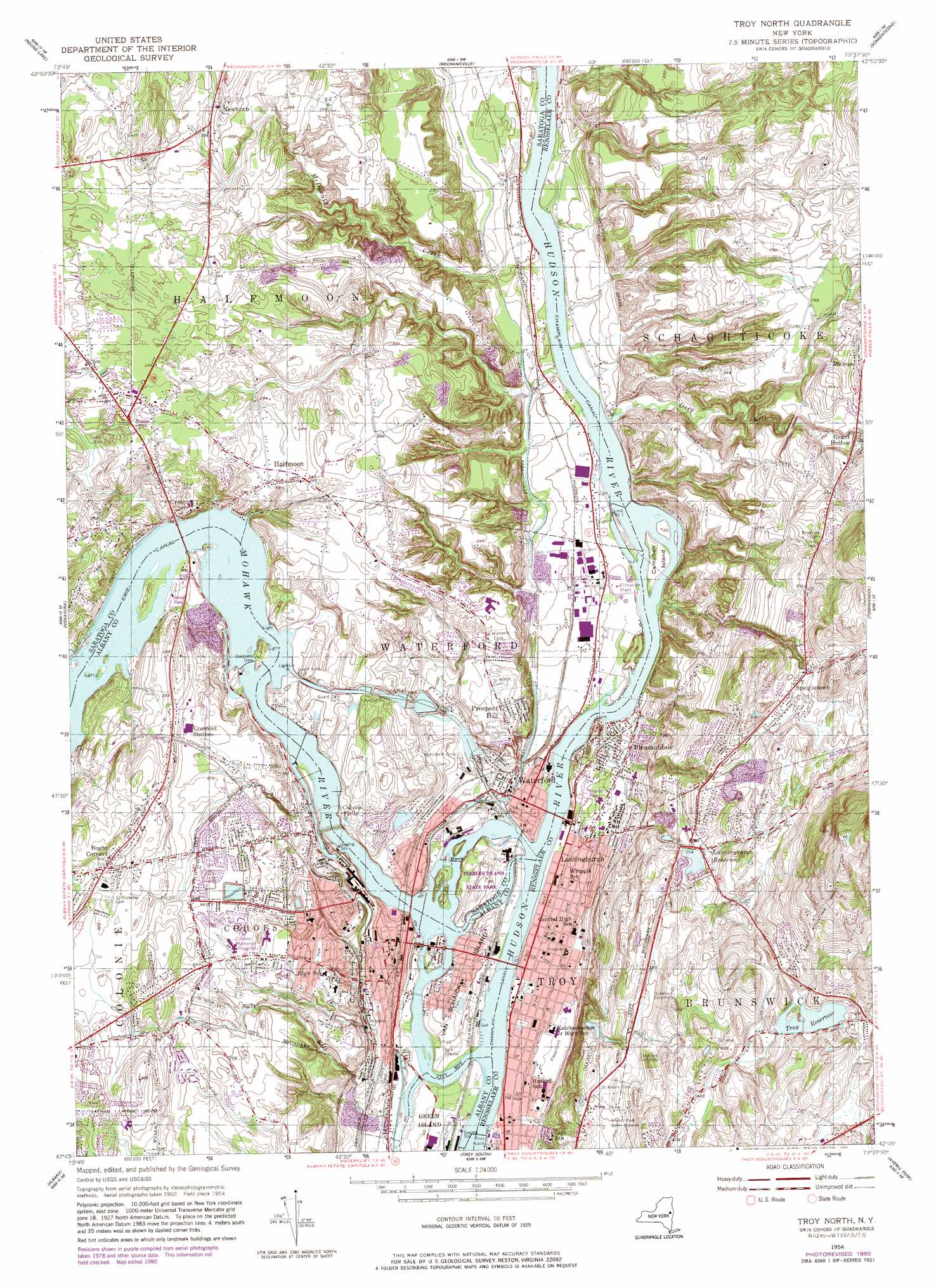
USGS Topo Quad 42073g6 - 1:24,000 scale
| Topo Map Name: | Troy North |
| USGS Topo Quad ID: | 42073g6 |
| Print Size: | ca. 21 1/4" wide x 27" high |
| Southeast Coordinates: | 42.75° N latitude / 73.625° W longitude |
| Map Center Coordinates: | 42.8125° N latitude / 73.6875° W longitude |
| U.S. State: | NY |
| Filename: | o42073g6.jpg |
| Download Map JPG Image: | Troy North topo map 1:24,000 scale |
| Map Type: | Topographic |
| Topo Series: | 7.5´ |
| Map Scale: | 1:24,000 |
| Source of Map Images: | United States Geological Survey (USGS) |
| Alternate Map Versions: |
Troy North NY 1954, updated 1956 Download PDF Buy paper map Troy North NY 1954, updated 1965 Download PDF Buy paper map Troy North NY 1954, updated 1976 Download PDF Buy paper map Troy North NY 1954, updated 1980 Download PDF Buy paper map Troy North NY 1978, updated 1982 Download PDF Buy paper map Troy North NY 2010 Download PDF Buy paper map Troy North NY 2013 Download PDF Buy paper map Troy North NY 2016 Download PDF Buy paper map |
1:24,000 Topo Quads surrounding Troy North
Middle Grove |
Saratoga Springs |
Quaker Springs |
Schuylerville |
Cambridge |
Burnt Hills |
Round Lake |
Mechanicville |
Schaghticoke |
Eagle Bridge |
Schenectady |
Niskayuna |
Troy North |
Tomhannock |
Grafton |
Voorheesville |
Albany |
Troy South |
Averill Park |
|
Clarksville |
Delmar |
East Greenbush |
Nassau |
> Back to 42073e1 at 1:100,000 scale
> Back to 42072a1 at 1:250,000 scale
> Back to U.S. Topo Maps home
Troy North topo map: Gazetteer
Troy North: Areas
The Triangle elevation 44m 144′Troy North: Bridges
112th Street Bridge elevation 3m 9′Troy-Waterford Bridge elevation 3m 9′
Troy North: Dams
Crescent Dam elevation 56m 183′Lock Number 1 elevation 9m 29′
Lock Number 2 elevation 9m 29′
Lock Number 4 elevation 34m 111′
Lock Number 5 elevation 46m 150′
Lock Number 6 elevation 56m 183′
Troy Lock elevation 0m 0′
Troy North: Falls
Buttermilk Falls elevation 6m 19′Cohoes Falls elevation 38m 124′
Troy North: Islands
Bock Island elevation 9m 29′Campbell Island elevation 8m 26′
Collins Island elevation 174m 570′
Fiona Island elevation 8m 26′
Goat Island elevation 18m 59′
Jan Gowson Island elevation 3m 9′
Peebles Island elevation 15m 49′
Peobles Island elevation 15m 49′
Second Island elevation 21m 68′
Simmons Island elevation 14m 45′
Van Schaick Island elevation 20m 65′
Troy North: Parks
Colonie Town Park elevation 68m 223′Greenbriar Park elevation 83m 272′
Knickerbocker Park elevation 12m 39′
Lansing Park elevation 70m 229′
Lansing Park elevation 11m 36′
Memorial Park elevation 9m 29′
Peebles Island State Park elevation 15m 49′
Powers Memorial Park elevation 10m 32′
Sunset Park elevation 75m 246′
Twilight Park elevation 75m 246′
Troy North: Populated Places
Ballards Mobile Home Court elevation 57m 187′Boght Corners elevation 108m 354′
Cohoes elevation 30m 98′
Colemans Trailer Park elevation 51m 167′
Crescent elevation 64m 209′
Crescent City Mobile Home Park elevation 76m 249′
Crescent Station elevation 88m 288′
Grant Hollow elevation 96m 314′
Halfmoon elevation 84m 275′
Hudson River Mobile Home Park elevation 6m 19′
Lansingburgh elevation 13m 42′
Midway Park elevation 80m 262′
Newtown elevation 95m 311′
Pine View Estates elevation 13m 42′
Pleasantdale elevation 13m 42′
Speigletown elevation 126m 413′
Sunnyside Trailer Court elevation 58m 190′
Ten Oaks Mobile Home Park elevation 93m 305′
Waterford elevation 21m 68′
Troy North: Reservoirs
Lansingburgh Reservoir elevation 88m 288′Troy Reservoir elevation 140m 459′
Troy North: Streams
Deep Kill elevation 6m 19′McDonald Creek elevation 10m 32′
Mohawk River elevation 3m 9′
Salt Kill elevation 6m 19′
Troy North: Summits
Prospect Hill elevation 55m 180′Troy North digital topo map on disk
Buy this Troy North topo map showing relief, roads, GPS coordinates and other geographical features, as a high-resolution digital map file on DVD:
New York, Vermont, Connecticut & Western Massachusetts
Buy digital topo maps: New York, Vermont, Connecticut & Western Massachusetts