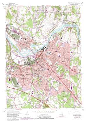
Schenectady Topo Map New York
To zoom in, hover over the map of Schenectady
USGS Topo Quad 42073g8 - 1:24,000 scale
| Topo Map Name: | Schenectady |
| USGS Topo Quad ID: | 42073g8 |
| Print Size: | ca. 21 1/4" wide x 27" high |
| Southeast Coordinates: | 42.75° N latitude / 73.875° W longitude |
| Map Center Coordinates: | 42.8125° N latitude / 73.9375° W longitude |
| U.S. State: | NY |
| Filename: | o42073g8.jpg |
| Download Map JPG Image: | Schenectady topo map 1:24,000 scale |
| Map Type: | Topographic |
| Topo Series: | 7.5´ |
| Map Scale: | 1:24,000 |
| Source of Map Images: | United States Geological Survey (USGS) |
| Alternate Map Versions: |
Schenectady NY 1954, updated 1957 Download PDF Buy paper map Schenectady NY 1954, updated 1965 Download PDF Buy paper map Schenectady NY 1954, updated 1981 Download PDF Buy paper map Schenectady NY 1954, updated 1981 Download PDF Buy paper map Schenectady NY 2010 Download PDF Buy paper map Schenectady NY 2013 Download PDF Buy paper map Schenectady NY 2016 Download PDF Buy paper map |
1:24,000 Topo Quads surrounding Schenectady
> Back to 42073e1 at 1:100,000 scale
> Back to 42072a1 at 1:250,000 scale
> Back to U.S. Topo Maps home
Schenectady topo map: Gazetteer
Schenectady: Airports
Jerry Phibbs Airport elevation 103m 337′Schenectady County Airport elevation 101m 331′
Wells Seaplane Base elevation 64m 209′
Schenectady: Bridges
Bridge 8, Erie Canal elevation 64m 209′Freemans Bridge elevation 64m 209′
Western Gateway Bridge elevation 64m 209′
Schenectady: Capes
Iroquois Peninsula elevation 68m 223′Schenectady: Crossings
Interchange Number 25 elevation 106m 347′Schenectady: Dams
Lock Number 8 elevation 67m 219′Schenectady: Islands
Dalys Island elevation 72m 236′Isle of the Cayugas elevation 67m 219′
Isle of the Mohawks elevation 67m 219′
Isle of the Oneidas elevation 70m 229′
Isle of the Onondagas elevation 67m 219′
Isle of the Senecas elevation 66m 216′
Van Slyck Island elevation 69m 226′
Schenectady: Lakes
Collins Lake elevation 64m 209′Iroquois Lake elevation 113m 370′
Schenectady: Parks
Alexander Field elevation 91m 298′Carman Park elevation 107m 351′
Central Park elevation 128m 419′
Chester Arthur Courtyard elevation 84m 275′
Collins Park elevation 68m 223′
Everett T Grout Athletic Field elevation 110m 360′
Frank Bailey Athletic Field and Track elevation 92m 301′
Hillhurst Park elevation 108m 354′
Ingersol Memorial for Aged Men elevation 125m 410′
Jackson's Garden elevation 85m 278′
Library Field elevation 84m 275′
Mount Pleasant Athletic Field elevation 103m 337′
Mrs. Perkin's Garden elevation 84m 275′
Pleasant Valley Park elevation 94m 308′
Poutre Park elevation 100m 328′
Riverside Park elevation 64m 209′
Robison Herb Garden elevation 84m 275′
Roger Hull Plaza elevation 86m 282′
Schenectady Park elevation 104m 341′
Schenectady Stadium elevation 109m 357′
Stanley and Geraldine Levine Wildflower Garden elevation 83m 272′
Steinmetz Memorial Park elevation 103m 337′
Steinmetz Park elevation 116m 380′
Veterans Park elevation 83m 272′
Schenectady: Populated Places
Alplaus elevation 79m 259′Aqueduct elevation 73m 239′
Bellevue elevation 103m 337′
Beukendaal elevation 97m 318′
Carman elevation 107m 351′
Coldbrook elevation 102m 334′
Glenridge elevation 90m 295′
Harding Crossing elevation 77m 252′
Hawthorne Hill elevation 134m 439′
Hungry Hill elevation 104m 341′
Hutchinson Crossing elevation 79m 259′
Mayfair elevation 106m 347′
Mount Pleasant elevation 104m 341′
Pine Grove elevation 97m 318′
Rexford elevation 76m 249′
Rotterdam elevation 103m 337′
Schenectady elevation 74m 242′
Schonowe elevation 90m 295′
Scotia elevation 74m 242′
South Schenectady elevation 103m 337′
Stanford Heights elevation 106m 347′
Steinmetz Homes elevation 104m 341′
Stoodley Corners elevation 107m 351′
Van Buren Park Homes elevation 126m 413′
Schenectady: Streams
Alplaus Kill elevation 64m 209′College Creek elevation 76m 249′
Collins Creek elevation 64m 209′
Indian Kill elevation 67m 219′
Poentic Kill elevation 64m 209′
Schenectady: Valleys
Pleasant Valley elevation 70m 229′Schenectady digital topo map on disk
Buy this Schenectady topo map showing relief, roads, GPS coordinates and other geographical features, as a high-resolution digital map file on DVD:
New York, Vermont, Connecticut & Western Massachusetts
Buy digital topo maps: New York, Vermont, Connecticut & Western Massachusetts


