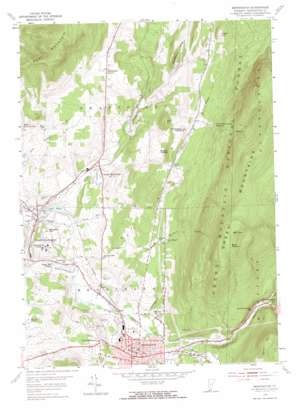
Bennington Topo Map Vermont
To zoom in, hover over the map of Bennington
USGS Topo Quad 42073h2 - 1:24,000 scale
| Topo Map Name: | Bennington |
| USGS Topo Quad ID: | 42073h2 |
| Print Size: | ca. 21 1/4" wide x 27" high |
| Southeast Coordinates: | 42.875° N latitude / 73.125° W longitude |
| Map Center Coordinates: | 42.9375° N latitude / 73.1875° W longitude |
| U.S. State: | VT |
| Filename: | o42073h2.jpg |
| Download Map JPG Image: | Bennington topo map 1:24,000 scale |
| Map Type: | Topographic |
| Topo Series: | 7.5´ |
| Map Scale: | 1:24,000 |
| Source of Map Images: | United States Geological Survey (USGS) |
| Alternate Map Versions: |
Bennington VT 1954, updated 1956 Download PDF Buy paper map Bennington VT 1954, updated 1965 Download PDF Buy paper map Bennington VT 1954, updated 1973 Download PDF Buy paper map Bennington VT 1997, updated 2000 Download PDF Buy paper map Bennington VT 2012 Download PDF Buy paper map Bennington VT 2015 Download PDF Buy paper map |
| FStopo: | US Forest Service topo Bennington is available: Download FStopo PDF Download FStopo TIF |
1:24,000 Topo Quads surrounding Bennington
> Back to 42073e1 at 1:100,000 scale
> Back to 42072a1 at 1:250,000 scale
> Back to U.S. Topo Maps home
Bennington topo map: Gazetteer
Bennington: Airports
Bennington Airport elevation 242m 793′William H Morse State Airport elevation 246m 807′
Bennington: Basins
Bear Wallow elevation 809m 2654′Bennington: Bridges
Paper Mill Village Bridge elevation 165m 541′Silk Road Covered Bridge elevation 170m 557′
Bennington: Crossings
Exit 1 elevation 177m 580′Exit 2 elevation 250m 820′
Bennington: Dams
Cider Mill Dam elevation 230m 754′Lake Paran Dam elevation 188m 616′
Bennington: Forests
Bennington Municipal Forest elevation 286m 938′North Bennington Memorial Forest elevation 771m 2529′
Bennington: Lakes
Lake Paran elevation 197m 646′Bennington: Parks
Bennington Battle Monument elevation 265m 869′Center Shaftsbury Historic District elevation 333m 1092′
Downtown Bennington Historic District elevation 207m 679′
Memorial Park elevation 226m 741′
Monument Square elevation 265m 869′
North Bennington Historic District elevation 195m 639′
Old Bennington Historic District elevation 243m 797′
Seth Warner Statue elevation 264m 866′
Willow Park elevation 258m 846′
Bennington: Populated Places
Bennington elevation 207m 679′North Bennington elevation 195m 639′
Old Bennington elevation 246m 807′
Paper Mill Village elevation 171m 561′
Shaftsbury Center elevation 332m 1089′
South Shaftsbury elevation 227m 744′
Bennington: Post Offices
Bennington Post Office elevation 207m 679′North Bennington Post Office elevation 199m 652′
Bennington: Reservoirs
Lake Paran elevation 188m 616′North Bennington Reservoir elevation 431m 1414′
Bennington: Streams
Barney Brook elevation 225m 738′Basin Brook elevation 382m 1253′
City Stream elevation 352m 1154′
Furnace Brook elevation 174m 570′
Paran Creek elevation 164m 538′
Roaring Branch Walloomsac Brook elevation 188m 616′
Stratton Brook elevation 254m 833′
Bennington: Summits
Bald Mountain elevation 868m 2847′Bingham Hill elevation 226m 741′
Bucks Cobble elevation 421m 1381′
Hale Mountain elevation 435m 1427′
Harrington Cobble elevation 437m 1433′
Maple Hill elevation 525m 1722′
Trumbull Mountain elevation 451m 1479′
Bennington: Trails
Bald Mountain Trail elevation 599m 1965′West Ridge Trail elevation 894m 2933′
Bennington: Woods
McCullough Woods elevation 209m 685′Bennington digital topo map on disk
Buy this Bennington topo map showing relief, roads, GPS coordinates and other geographical features, as a high-resolution digital map file on DVD:
New York, Vermont, Connecticut & Western Massachusetts
Buy digital topo maps: New York, Vermont, Connecticut & Western Massachusetts


