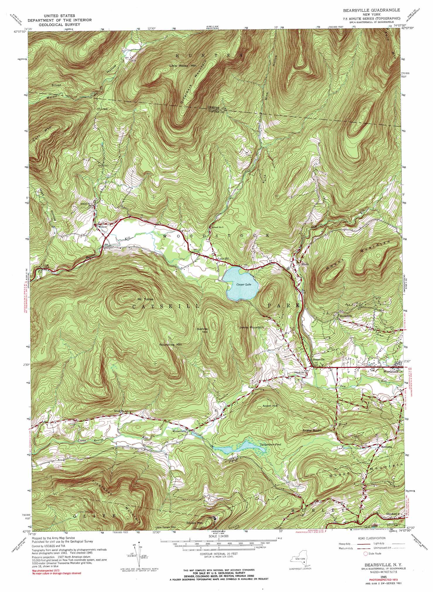
Bearsville Topo Map New York
To zoom in, hover over the map of Bearsville
USGS Topo Quad 42074a2 - 1:24,000 scale
| Topo Map Name: | Bearsville |
| USGS Topo Quad ID: | 42074a2 |
| Print Size: | ca. 21 1/4" wide x 27" high |
| Southeast Coordinates: | 42° N latitude / 74.125° W longitude |
| Map Center Coordinates: | 42.0625° N latitude / 74.1875° W longitude |
| U.S. State: | NY |
| Filename: | o42074a2.jpg |
| Download Map JPG Image: | Bearsville topo map 1:24,000 scale |
| Map Type: | Topographic |
| Topo Series: | 7.5´ |
| Map Scale: | 1:24,000 |
| Source of Map Images: | United States Geological Survey (USGS) |
| Alternate Map Versions: |
Bearsville NY 1945, updated 1962 Download PDF Buy paper map Bearsville NY 1945, updated 1968 Download PDF Buy paper map Bearsville NY 1945, updated 1990 Download PDF Buy paper map Bearsville NY 1946 Download PDF Buy paper map Bearsville NY 1997, updated 2001 Download PDF Buy paper map Bearsville NY 2010 Download PDF Buy paper map Bearsville NY 2013 Download PDF Buy paper map Bearsville NY 2016 Download PDF Buy paper map |
1:24,000 Topo Quads surrounding Bearsville
Prattsville |
Ashland |
Hensonville |
Freehold |
Leeds |
West Kill |
Lexington |
Hunter |
Kaaterskill |
Cementon |
Shandaken |
Phoenicia |
Bearsville |
Woodstock |
Saugerties |
Peekamoose Mountain |
West Shokan |
Ashokan |
Kingston West |
Kingston East |
Rondout Reservoir |
Kerhonkson |
Mohonk Lake |
Rosendale |
Hyde Park |
> Back to 42074a1 at 1:100,000 scale
> Back to 42074a1 at 1:250,000 scale
> Back to U.S. Topo Maps home
Bearsville topo map: Gazetteer
Bearsville: Populated Places
Bearsville elevation 213m 698′Byrdcliffe elevation 268m 879′
Glenford elevation 201m 659′
Lake Hill elevation 338m 1108′
Montoma elevation 311m 1020′
Shady elevation 297m 974′
Willow elevation 333m 1092′
Wittenberg elevation 251m 823′
Bearsville: Reservoirs
Cooper Lake elevation 335m 1099′Yanketown Pond elevation 257m 843′
Bearsville: Summits
Acorn Hill elevation 398m 1305′Beetree Hill elevation 555m 1820′
Carl Mountain elevation 879m 2883′
Johns Mountain elevation 466m 1528′
Little Rocky Mountain elevation 930m 3051′
Mount Guardian elevation 535m 1755′
Mount Tobias elevation 775m 2542′
Ohayo Mountain elevation 423m 1387′
Olderbark Mountain elevation 1048m 3438′
Roundtop Mountain elevation 605m 1984′
Snake Rocks elevation 368m 1207′
Ticetonyk Mountain elevation 765m 2509′
Tonshi Mountain elevation 607m 1991′
Bearsville: Valleys
Hoyt Hollow elevation 288m 944′Mink Hollow elevation 351m 1151′
Bearsville digital topo map on disk
Buy this Bearsville topo map showing relief, roads, GPS coordinates and other geographical features, as a high-resolution digital map file on DVD:
New York, Vermont, Connecticut & Western Massachusetts
Buy digital topo maps: New York, Vermont, Connecticut & Western Massachusetts