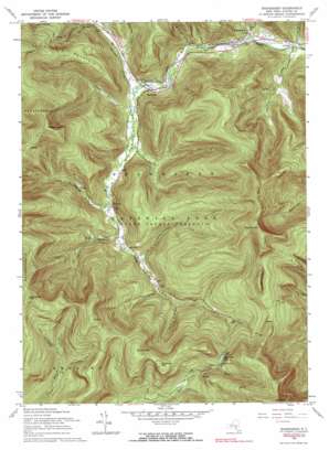
Shandaken Topo Map New York
To zoom in, hover over the map of Shandaken
USGS Topo Quad 42074a4 - 1:24,000 scale
| Topo Map Name: | Shandaken |
| USGS Topo Quad ID: | 42074a4 |
| Print Size: | ca. 21 1/4" wide x 27" high |
| Southeast Coordinates: | 42° N latitude / 74.375° W longitude |
| Map Center Coordinates: | 42.0625° N latitude / 74.4375° W longitude |
| U.S. State: | NY |
| Filename: | o42074a4.jpg |
| Download Map JPG Image: | Shandaken topo map 1:24,000 scale |
| Map Type: | Topographic |
| Topo Series: | 7.5´ |
| Map Scale: | 1:24,000 |
| Source of Map Images: | United States Geological Survey (USGS) |
| Alternate Map Versions: |
Shandaken NY 1946 Download PDF Buy paper map Shandaken NY 1946 Download PDF Buy paper map Shandaken NY 1960, updated 1961 Download PDF Buy paper map Shandaken NY 1960, updated 1969 Download PDF Buy paper map Shandaken NY 1960, updated 1990 Download PDF Buy paper map Shandaken NY 1960, updated 1990 Download PDF Buy paper map Shandaken NY 1997, updated 2001 Download PDF Buy paper map Shandaken NY 2010 Download PDF Buy paper map Shandaken NY 2013 Download PDF Buy paper map Shandaken NY 2016 Download PDF Buy paper map |
1:24,000 Topo Quads surrounding Shandaken
> Back to 42074a1 at 1:100,000 scale
> Back to 42074a1 at 1:250,000 scale
> Back to U.S. Topo Maps home
Shandaken topo map: Gazetteer
Shandaken: Cliffs
Giant Ledge elevation 932m 3057′Shandaken: Parks
Catskill State Park elevation 681m 2234′Shandaken: Populated Places
Big Indian elevation 371m 1217′Oliverea elevation 432m 1417′
Shandaken elevation 322m 1056′
Shandaken: Reservoirs
Winnisook Lake elevation 813m 2667′Shandaken: Streams
Birch Creek elevation 360m 1181′Bushnellsville Creek elevation 320m 1049′
Elk Bushkill elevation 449m 1473′
Giant Ledge Stream elevation 554m 1817′
Shandaken: Summits
Balsam Mountain elevation 1098m 3602′Belle Ayr Mountain elevation 1027m 3369′
Big Indian Mountain elevation 1121m 3677′
Fir Mountain elevation 1106m 3628′
Hemlock Mountain elevation 990m 3248′
Panther Mountain elevation 1135m 3723′
Spruce Mountain elevation 1032m 3385′
Shandaken: Trails
Seager West Branch Trail elevation 788m 2585′Shandaken: Valleys
Big Indian Hollow elevation 367m 1204′Fox Hollow elevation 326m 1069′
Hanging Birds Nest elevation 525m 1722′
Hatchery Hollow elevation 401m 1315′
Little Peck Hollow elevation 472m 1548′
Lost Clove elevation 389m 1276′
McKenley Hollow elevation 442m 1450′
Millbrook Hollow elevation 352m 1154′
Peck Hollow elevation 309m 1013′
Rochester Hollow elevation 396m 1299′
Seneca Hollow elevation 338m 1108′
Shandaken digital topo map on disk
Buy this Shandaken topo map showing relief, roads, GPS coordinates and other geographical features, as a high-resolution digital map file on DVD:
New York, Vermont, Connecticut & Western Massachusetts
Buy digital topo maps: New York, Vermont, Connecticut & Western Massachusetts


