West Kill Topo Map New York
To zoom in, hover over the map of West Kill
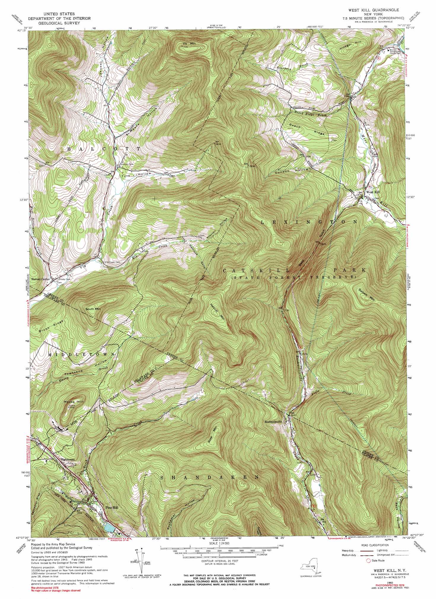
USGS Topo Quad 42074b4 - 1:24,000 scale
| Topo Map Name: | West Kill |
| USGS Topo Quad ID: | 42074b4 |
| Print Size: | ca. 21 1/4" wide x 27" high |
| Southeast Coordinates: | 42.125° N latitude / 74.375° W longitude |
| Map Center Coordinates: | 42.1875° N latitude / 74.4375° W longitude |
| U.S. State: | NY |
| Filename: | o42074b4.jpg |
| Download Map JPG Image: | West Kill topo map 1:24,000 scale |
| Map Type: | Topographic |
| Topo Series: | 7.5´ |
| Map Scale: | 1:24,000 |
| Source of Map Images: | United States Geological Survey (USGS) |
| Alternate Map Versions: |
West Kill NY 1945, updated 1946 Download PDF Buy paper map West Kill NY 1960, updated 1962 Download PDF Buy paper map West Kill NY 1960, updated 1966 Download PDF Buy paper map West Kill NY 1960, updated 1990 Download PDF Buy paper map West Kill NY 2010 Download PDF Buy paper map West Kill NY 2013 Download PDF Buy paper map West Kill NY 2016 Download PDF Buy paper map |
1:24,000 Topo Quads surrounding West Kill
Harpersfield |
Stamford |
Gilboa |
Livingstonville |
Durham |
Hobart |
Roxbury |
Prattsville |
Ashland |
Hensonville |
Margaretville |
Fleischmanns |
West Kill |
Lexington |
Hunter |
Arena |
Seager |
Shandaken |
Phoenicia |
Bearsville |
Willowemoc |
Claryville |
Peekamoose Mountain |
West Shokan |
Ashokan |
> Back to 42074a1 at 1:100,000 scale
> Back to 42074a1 at 1:250,000 scale
> Back to U.S. Topo Maps home
West Kill topo map: Gazetteer
West Kill: Gaps
Deep Notch elevation 585m 1919′West Kill: Populated Places
Bushnellsville elevation 447m 1466′Halcott Center elevation 531m 1742′
Highmount elevation 566m 1856′
Pine Hill elevation 457m 1499′
West Kill elevation 448m 1469′
West Kill: Ridges
Beech Ridge elevation 587m 1925′West Kill: Streams
Angle Creek elevation 450m 1476′Beech Ridge Brook elevation 420m 1377′
Elk Creek elevation 540m 1771′
Roarback Brook elevation 415m 1361′
West Kill elevation 396m 1299′
West Settlement Creek elevation 522m 1712′
West Kill: Summits
Balsam Mountain elevation 1022m 3353′Halcott Mountain elevation 1074m 3523′
Monka Hill elevation 757m 2483′
Rose Mountain elevation 942m 3090′
South Mountain elevation 865m 2837′
Vinegar Hill elevation 625m 2050′
Vly Mountain elevation 1076m 3530′
West Kill: Valleys
Cathedral Glen elevation 456m 1496′Condon Hollow elevation 552m 1811′
Giggle Hollow elevation 425m 1394′
Hemlock Gully elevation 608m 1994′
Johnson Hollow elevation 623m 2043′
Si Meade Hollow elevation 596m 1955′
Stanton Hollow elevation 636m 2086′
Turk Hollow elevation 572m 1876′
West Kill digital topo map on disk
Buy this West Kill topo map showing relief, roads, GPS coordinates and other geographical features, as a high-resolution digital map file on DVD:
New York, Vermont, Connecticut & Western Massachusetts
Buy digital topo maps: New York, Vermont, Connecticut & Western Massachusetts