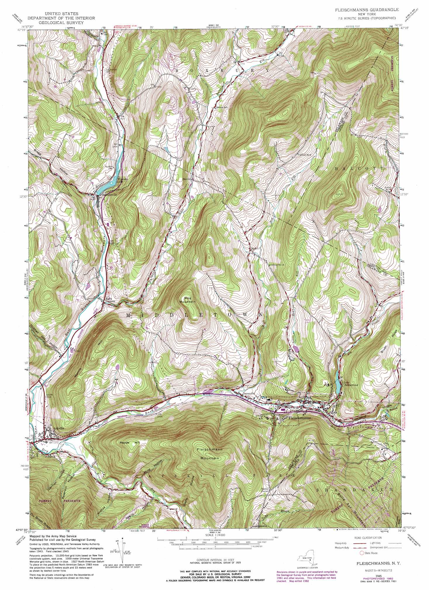
Fleischmanns Topo Map New York
To zoom in, hover over the map of Fleischmanns
USGS Topo Quad 42074b5 - 1:24,000 scale
| Topo Map Name: | Fleischmanns |
| USGS Topo Quad ID: | 42074b5 |
| Print Size: | ca. 21 1/4" wide x 27" high |
| Southeast Coordinates: | 42.125° N latitude / 74.5° W longitude |
| Map Center Coordinates: | 42.1875° N latitude / 74.5625° W longitude |
| U.S. State: | NY |
| Filename: | o42074b5.jpg |
| Download Map JPG Image: | Fleischmanns topo map 1:24,000 scale |
| Map Type: | Topographic |
| Topo Series: | 7.5´ |
| Map Scale: | 1:24,000 |
| Source of Map Images: | United States Geological Survey (USGS) |
| Alternate Map Versions: |
Fleischmanns NY 1945, updated 1946 Download PDF Buy paper map Fleischmanns NY 1945, updated 1963 Download PDF Buy paper map Fleischmanns NY 1945, updated 1970 Download PDF Buy paper map Fleischmanns NY 1945, updated 1983 Download PDF Buy paper map Fleischmanns NY 1946 Download PDF Buy paper map Fleischmanns NY 2010 Download PDF Buy paper map Fleischmanns NY 2013 Download PDF Buy paper map Fleischmanns NY 2016 Download PDF Buy paper map |
1:24,000 Topo Quads surrounding Fleischmanns
Davenport |
Harpersfield |
Stamford |
Gilboa |
Livingstonville |
Bloomville |
Hobart |
Roxbury |
Prattsville |
Ashland |
Andes |
Margaretville |
Fleischmanns |
West Kill |
Lexington |
Lewbeach |
Arena |
Seager |
Shandaken |
Phoenicia |
Livingston Manor |
Willowemoc |
Claryville |
Peekamoose Mountain |
West Shokan |
> Back to 42074a1 at 1:100,000 scale
> Back to 42074a1 at 1:250,000 scale
> Back to U.S. Topo Maps home
Fleischmanns topo map: Gazetteer
Fleischmanns: Lakes
Wawaka Lake elevation 428m 1404′Fleischmanns: Parks
Belleayre Mountain Winter Snow Park elevation 829m 2719′Fleischmann Athletic Park elevation 454m 1489′
Fleischmanns: Populated Places
Arkville elevation 416m 1364′Bedell elevation 565m 1853′
Clovesville elevation 442m 1450′
Denver elevation 497m 1630′
Fleischmanns elevation 457m 1499′
Halcottsville elevation 427m 1400′
Hanley Corner elevation 704m 2309′
Kelly Corners elevation 423m 1387′
Fleischmanns: Reservoirs
Lake Switzerland elevation 475m 1558′Fleischmanns: Ridges
Brush Ridge elevation 658m 2158′Red Kill Ridge elevation 918m 3011′
Fleischmanns: Streams
Batavia Kill elevation 416m 1364′Bush Kill elevation 412m 1351′
Emory Brook elevation 456m 1496′
Little Red Kill elevation 455m 1492′
Red Kill elevation 438m 1437′
Vly Creek elevation 456m 1496′
Fleischmanns: Summits
Fleischmann Mountain elevation 887m 2910′Hog Mountain elevation 795m 2608′
Meade Hill elevation 692m 2270′
Morris Hill elevation 704m 2309′
Fleischmanns: Valleys
Andrus Hollow elevation 433m 1420′Bragg Hollow elevation 426m 1397′
Castle Hollow elevation 456m 1496′
German Hollow elevation 416m 1364′
Hubbell Hill Hollow elevation 414m 1358′
Meeker Hollow elevation 441m 1446′
Mine Hollow elevation 442m 1450′
Negro Hollow elevation 449m 1473′
Reservoir Hollow elevation 427m 1400′
Townsend Hollow elevation 456m 1496′
Fleischmanns digital topo map on disk
Buy this Fleischmanns topo map showing relief, roads, GPS coordinates and other geographical features, as a high-resolution digital map file on DVD:
New York, Vermont, Connecticut & Western Massachusetts
Buy digital topo maps: New York, Vermont, Connecticut & Western Massachusetts