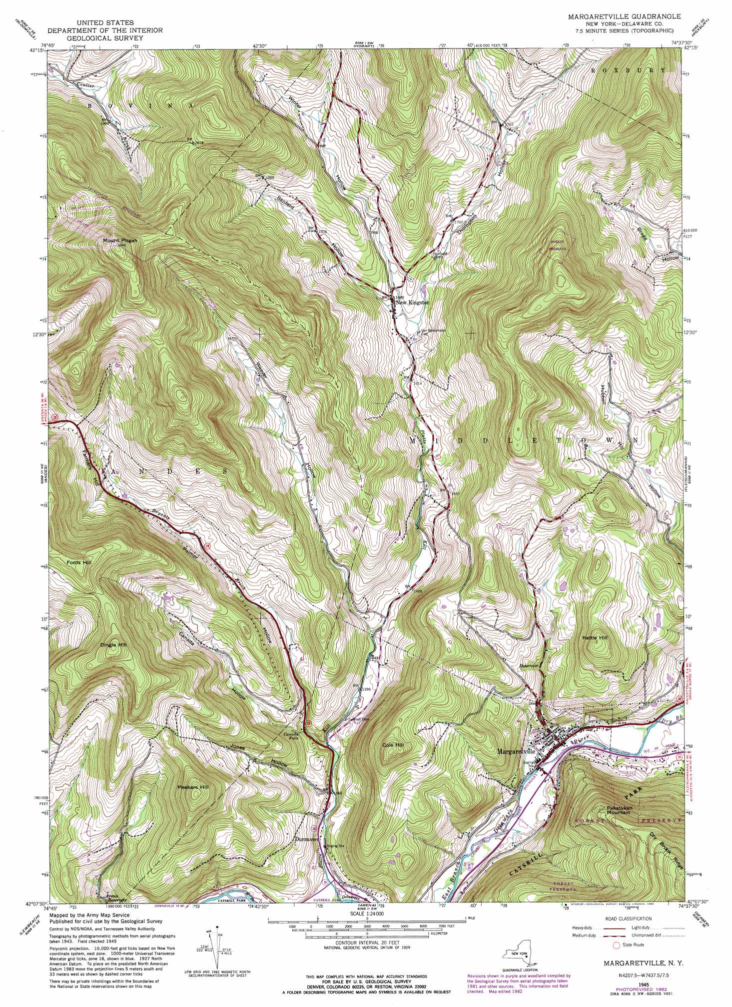
Margaretville Topo Map New York
To zoom in, hover over the map of Margaretville
USGS Topo Quad 42074b6 - 1:24,000 scale
| Topo Map Name: | Margaretville |
| USGS Topo Quad ID: | 42074b6 |
| Print Size: | ca. 21 1/4" wide x 27" high |
| Southeast Coordinates: | 42.125° N latitude / 74.625° W longitude |
| Map Center Coordinates: | 42.1875° N latitude / 74.6875° W longitude |
| U.S. State: | NY |
| Filename: | o42074b6.jpg |
| Download Map JPG Image: | Margaretville topo map 1:24,000 scale |
| Map Type: | Topographic |
| Topo Series: | 7.5´ |
| Map Scale: | 1:24,000 |
| Source of Map Images: | United States Geological Survey (USGS) |
| Alternate Map Versions: |
Margaretville NY 1945, updated 1963 Download PDF Buy paper map Margaretville NY 1945, updated 1972 Download PDF Buy paper map Margaretville NY 1945, updated 1983 Download PDF Buy paper map Margaretville NY 1946 Download PDF Buy paper map Margaretville NY 2010 Download PDF Buy paper map Margaretville NY 2013 Download PDF Buy paper map Margaretville NY 2016 Download PDF Buy paper map |
1:24,000 Topo Quads surrounding Margaretville
West Davenport |
Davenport |
Harpersfield |
Stamford |
Gilboa |
Delhi |
Bloomville |
Hobart |
Roxbury |
Prattsville |
Hamden |
Andes |
Margaretville |
Fleischmanns |
West Kill |
Downsville |
Lewbeach |
Arena |
Seager |
Shandaken |
Roscoe |
Livingston Manor |
Willowemoc |
Claryville |
Peekamoose Mountain |
> Back to 42074a1 at 1:100,000 scale
> Back to 42074a1 at 1:250,000 scale
> Back to U.S. Topo Maps home
Margaretville topo map: Gazetteer
Margaretville: Airports
Elliott Homestead Landing Strip elevation 586m 1922′Margaretville: Falls
Canada Falls elevation 435m 1427′Margaretville: Parks
Catskill Park elevation 654m 2145′Margaretville: Populated Places
Dunraven elevation 412m 1351′Margaretville elevation 401m 1315′
New Kingston elevation 514m 1686′
Margaretville: Reservoirs
Arena Reservoir elevation 429m 1407′Margaretville: Streams
Bryants Brook elevation 415m 1361′Dry Brook elevation 402m 1318′
Platte Kill elevation 390m 1279′
Margaretville: Summits
Cole Hill elevation 721m 2365′Dingle Hill elevation 862m 2828′
Farmers Hill elevation 602m 1975′
Fords Hill elevation 860m 2821′
Kettle Hill elevation 669m 2194′
Meekers Hill elevation 770m 2526′
Mount Pisgah elevation 1018m 3339′
Pakatakan Mountain elevation 743m 2437′
Margaretville: Valleys
Canada Hollow elevation 426m 1397′Jones Hollow elevation 409m 1341′
Palmer Hollow elevation 415m 1361′
Sanford Hollow elevation 500m 1640′
Thompson Hollow elevation 498m 1633′
Weaver Hollow elevation 437m 1433′
Winter Hollow elevation 500m 1640′
Margaretville digital topo map on disk
Buy this Margaretville topo map showing relief, roads, GPS coordinates and other geographical features, as a high-resolution digital map file on DVD:
New York, Vermont, Connecticut & Western Massachusetts
Buy digital topo maps: New York, Vermont, Connecticut & Western Massachusetts