Andes Topo Map New York
To zoom in, hover over the map of Andes
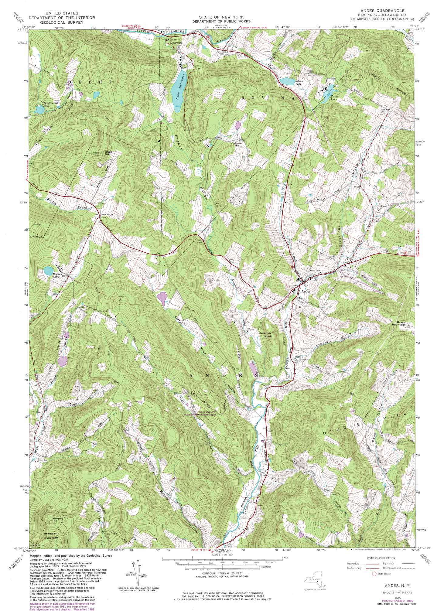
USGS Topo Quad 42074b7 - 1:24,000 scale
| Topo Map Name: | Andes |
| USGS Topo Quad ID: | 42074b7 |
| Print Size: | ca. 21 1/4" wide x 27" high |
| Southeast Coordinates: | 42.125° N latitude / 74.75° W longitude |
| Map Center Coordinates: | 42.1875° N latitude / 74.8125° W longitude |
| U.S. State: | NY |
| Filename: | o42074b7.jpg |
| Download Map JPG Image: | Andes topo map 1:24,000 scale |
| Map Type: | Topographic |
| Topo Series: | 7.5´ |
| Map Scale: | 1:24,000 |
| Source of Map Images: | United States Geological Survey (USGS) |
| Alternate Map Versions: |
Andes NY 1965, updated 1967 Download PDF Buy paper map Andes NY 1965, updated 1982 Download PDF Buy paper map Andes NY 1965, updated 1982 Download PDF Buy paper map Andes NY 2010 Download PDF Buy paper map Andes NY 2013 Download PDF Buy paper map Andes NY 2016 Download PDF Buy paper map |
1:24,000 Topo Quads surrounding Andes
Oneonta |
West Davenport |
Davenport |
Harpersfield |
Stamford |
Treadwell |
Delhi |
Bloomville |
Hobart |
Roxbury |
Walton East |
Hamden |
Andes |
Margaretville |
Fleischmanns |
Corbett |
Downsville |
Lewbeach |
Arena |
Seager |
Horton |
Roscoe |
Livingston Manor |
Willowemoc |
Claryville |
> Back to 42074a1 at 1:100,000 scale
> Back to 42074a1 at 1:250,000 scale
> Back to U.S. Topo Maps home
Andes topo map: Gazetteer
Andes: Lakes
Brydon Lake elevation 604m 1981′Andes: Populated Places
Andes elevation 487m 1597′Lake Delaware elevation 473m 1551′
Andes: Reservoirs
Lake Delaware elevation 550m 1804′Silver Lake elevation 551m 1807′
Tanglewood Lake elevation 569m 1866′
Tunis Lake elevation 608m 1994′
Andes: Streams
Liddle Brook elevation 486m 1594′Andes: Summits
Calhoun Hill elevation 631m 2070′Craig Hill elevation 811m 2660′
Grays Mountain elevation 878m 2880′
Hemlock Knoll elevation 585m 1919′
Murphy Hill elevation 703m 2306′
Andes: Valleys
Bigger Hollow elevation 494m 1620′Bullet Hole elevation 441m 1446′
Campbell Hollow elevation 470m 1541′
Davis Hollow elevation 489m 1604′
Gladstone Hollow elevation 512m 1679′
Skink Hollow elevation 467m 1532′
Skunk Hollow elevation 469m 1538′
State Road Hollow elevation 446m 1463′
Wolf Hollow elevation 425m 1394′
Andes digital topo map on disk
Buy this Andes topo map showing relief, roads, GPS coordinates and other geographical features, as a high-resolution digital map file on DVD:
New York, Vermont, Connecticut & Western Massachusetts
Buy digital topo maps: New York, Vermont, Connecticut & Western Massachusetts