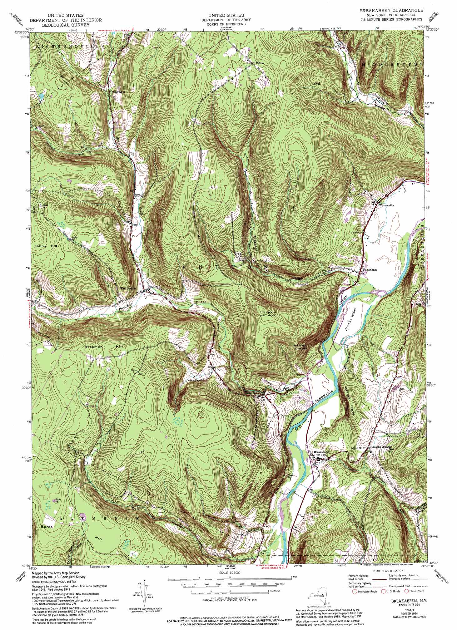
Breakabeen Topo Map New York
To zoom in, hover over the map of Breakabeen
USGS Topo Quad 42074e4 - 1:24,000 scale
| Topo Map Name: | Breakabeen |
| USGS Topo Quad ID: | 42074e4 |
| Print Size: | ca. 21 1/4" wide x 27" high |
| Southeast Coordinates: | 42.5° N latitude / 74.375° W longitude |
| Map Center Coordinates: | 42.5625° N latitude / 74.4375° W longitude |
| U.S. State: | NY |
| Filename: | o42074e4.jpg |
| Download Map JPG Image: | Breakabeen topo map 1:24,000 scale |
| Map Type: | Topographic |
| Topo Series: | 7.5´ |
| Map Scale: | 1:24,000 |
| Source of Map Images: | United States Geological Survey (USGS) |
| Alternate Map Versions: |
Breakabeen NY 1943, updated 1959 Download PDF Buy paper map Breakabeen NY 1943, updated 1959 Download PDF Buy paper map Breakabeen NY 1943, updated 1980 Download PDF Buy paper map Breakabeen NY 1943, updated 1988 Download PDF Buy paper map Breakabeen NY 1943, updated 1994 Download PDF Buy paper map Breakabeen NY 2010 Download PDF Buy paper map Breakabeen NY 2013 Download PDF Buy paper map Breakabeen NY 2016 Download PDF Buy paper map |
1:24,000 Topo Quads surrounding Breakabeen
Sprout Brook |
Sharon Springs |
Carlisle |
Esperance |
Duanesburg |
South Valley |
Richmondville |
Cobleskill |
Schoharie |
Gallupville |
Charlotteville |
Summit |
Breakabeen |
Middleburgh |
Rensselaerville |
Harpersfield |
Stamford |
Gilboa |
Livingstonville |
Durham |
Hobart |
Roxbury |
Prattsville |
Ashland |
Hensonville |
> Back to 42074e1 at 1:100,000 scale
> Back to 42074a1 at 1:250,000 scale
> Back to U.S. Topo Maps home
Breakabeen topo map: Gazetteer
Breakabeen: Falls
Boucks Falls elevation 258m 846′Breakabeen: Islands
Boucks Island elevation 207m 679′Breakabeen: Parks
Max V Shaul State Park elevation 250m 820′Breakabeen: Populated Places
Breakabeen elevation 226m 741′Fultonham elevation 214m 702′
Patria elevation 600m 1968′
Vintonton elevation 440m 1443′
Watsonville elevation 211m 692′
West Fulton elevation 353m 1158′
Breakabeen: Streams
Cole Brook elevation 225m 738′Heathen Creek elevation 402m 1318′
House Creek elevation 347m 1138′
Keyser Kill elevation 219m 718′
Panther Creek elevation 208m 682′
Breakabeen: Summits
Fulton Hill elevation 665m 2181′Rossman Hill elevation 634m 2080′
Towpath Mountain elevation 592m 1942′
Walhalla Rocks elevation 391m 1282′
Breakabeen: Valleys
Cole Hollow elevation 225m 738′Dibble Hollow elevation 356m 1167′
Pleasant Valley elevation 210m 688′
Warner Hollow elevation 318m 1043′
Breakabeen digital topo map on disk
Buy this Breakabeen topo map showing relief, roads, GPS coordinates and other geographical features, as a high-resolution digital map file on DVD:
New York, Vermont, Connecticut & Western Massachusetts
Buy digital topo maps: New York, Vermont, Connecticut & Western Massachusetts