Cooperstown Topo Map New York
To zoom in, hover over the map of Cooperstown
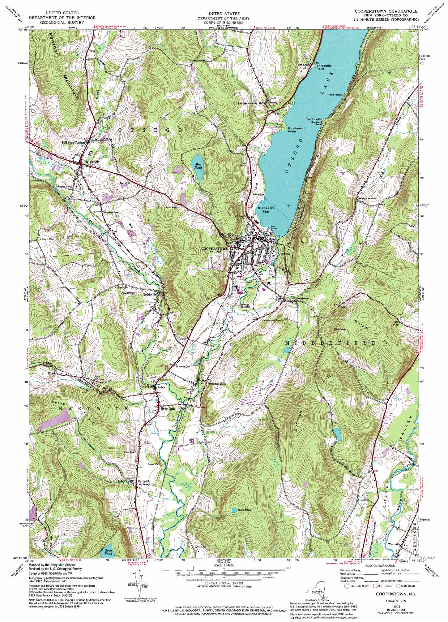
USGS Topo Quad 42074f8 - 1:24,000 scale
| Topo Map Name: | Cooperstown |
| USGS Topo Quad ID: | 42074f8 |
| Print Size: | ca. 21 1/4" wide x 27" high |
| Southeast Coordinates: | 42.625° N latitude / 74.875° W longitude |
| Map Center Coordinates: | 42.6875° N latitude / 74.9375° W longitude |
| U.S. State: | NY |
| Filename: | o42074f8.jpg |
| Download Map JPG Image: | Cooperstown topo map 1:24,000 scale |
| Map Type: | Topographic |
| Topo Series: | 7.5´ |
| Map Scale: | 1:24,000 |
| Source of Map Images: | United States Geological Survey (USGS) |
| Alternate Map Versions: |
Cooperstown NY 1943, updated 1960 Download PDF Buy paper map Cooperstown NY 1943, updated 1970 Download PDF Buy paper map Cooperstown NY 1943, updated 1992 Download PDF Buy paper map Cooperstown NY 1943, updated 1994 Download PDF Buy paper map Cooperstown NY 2010 Download PDF Buy paper map Cooperstown NY 2013 Download PDF Buy paper map Cooperstown NY 2016 Download PDF Buy paper map |
1:24,000 Topo Quads surrounding Cooperstown
West Winfield |
Millers Mills |
Jordanville |
Van Hornesville |
Fort Plain |
Unadilla Forks |
Schuyler Lake |
Richfield Springs |
East Springfield |
Sprout Brook |
Edmeston |
Hartwick |
Cooperstown |
Westford |
South Valley |
Morris |
Mount Vision |
Milford |
Schenevus |
Charlotteville |
Otego |
Oneonta |
West Davenport |
Davenport |
Harpersfield |
> Back to 42074e1 at 1:100,000 scale
> Back to 42074a1 at 1:250,000 scale
> Back to U.S. Topo Maps home
Cooperstown topo map: Gazetteer
Cooperstown: Airports
Cooperstown-Westville Airport elevation 375m 1230′Cooperstown: Bays
Blackbird Bay elevation 363m 1190′Cooperstown: Capes
Brookwood Point elevation 365m 1197′Point Florence elevation 365m 1197′
Point Judity elevation 366m 1200′
Threemile Point elevation 368m 1207′
Cooperstown: Falls
Leatherstocking Falls elevation 418m 1371′Cooperstown: Lakes
Goey Pond elevation 496m 1627′Moss Pond elevation 533m 1748′
Cooperstown: Parks
Cooper Grounds Park elevation 377m 1236′Doubleday Field elevation 377m 1236′
Cooperstown: Populated Places
Bowerstown elevation 389m 1276′Chase elevation 415m 1361′
Cooperstown elevation 374m 1227′
Fly Creek elevation 397m 1302′
Hartwick Seminary elevation 384m 1259′
Hyde Park elevation 370m 1213′
Index elevation 361m 1184′
Pail Shop Corners elevation 397m 1302′
Phoenix Mills elevation 378m 1240′
Toddsville elevation 379m 1243′
Westville elevation 374m 1227′
Whig Corners elevation 421m 1381′
Cooperstown: Streams
Chase Creek elevation 354m 1161′Fly Creek elevation 378m 1240′
Oaks Creek elevation 354m 1161′
Red Creek elevation 360m 1181′
Cooperstown: Summits
Burke Hill elevation 543m 1781′Cornish Hill elevation 680m 2230′
Murphy Hill elevation 540m 1771′
Cooperstown: Valleys
Chase Gorge elevation 385m 1263′Cooperstown digital topo map on disk
Buy this Cooperstown topo map showing relief, roads, GPS coordinates and other geographical features, as a high-resolution digital map file on DVD:
New York, Vermont, Connecticut & Western Massachusetts
Buy digital topo maps: New York, Vermont, Connecticut & Western Massachusetts