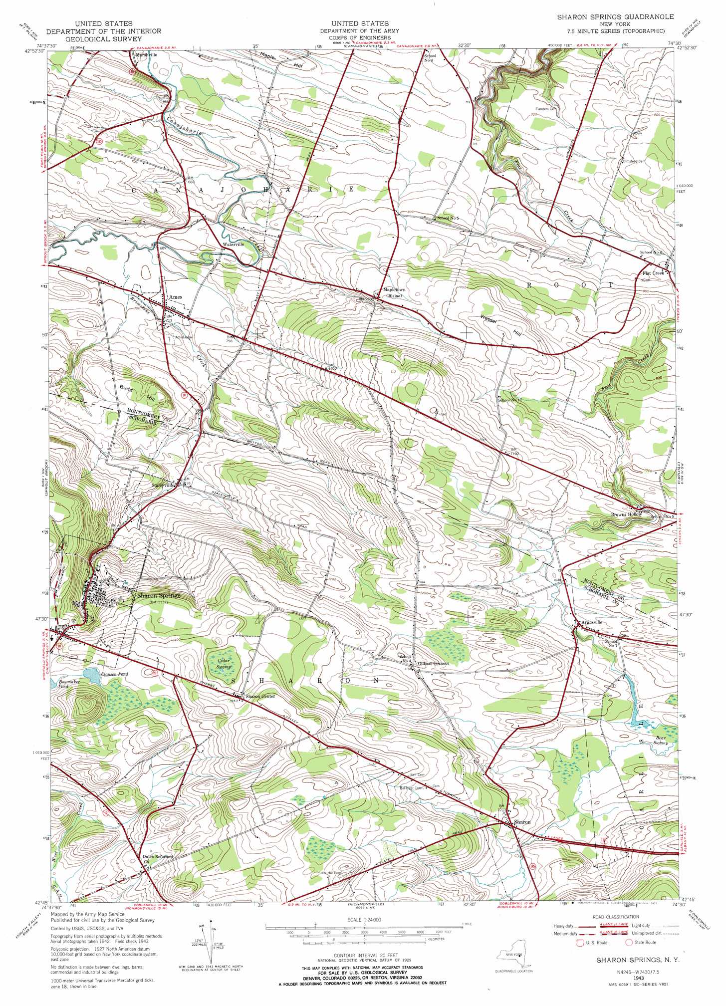
Sharon Springs Topo Map New York
To zoom in, hover over the map of Sharon Springs
USGS Topo Quad 42074g5 - 1:24,000 scale
| Topo Map Name: | Sharon Springs |
| USGS Topo Quad ID: | 42074g5 |
| Print Size: | ca. 21 1/4" wide x 27" high |
| Southeast Coordinates: | 42.75° N latitude / 74.5° W longitude |
| Map Center Coordinates: | 42.8125° N latitude / 74.5625° W longitude |
| U.S. State: | NY |
| Filename: | o42074g5.jpg |
| Download Map JPG Image: | Sharon Springs topo map 1:24,000 scale |
| Map Type: | Topographic |
| Topo Series: | 7.5´ |
| Map Scale: | 1:24,000 |
| Source of Map Images: | United States Geological Survey (USGS) |
| Alternate Map Versions: |
Sharon Springs NY 1943, updated 1955 Download PDF Buy paper map Sharon Springs NY 1943, updated 1971 Download PDF Buy paper map Sharon Springs NY 1943, updated 1977 Download PDF Buy paper map Sharon Springs NY 2010 Download PDF Buy paper map Sharon Springs NY 2013 Download PDF Buy paper map Sharon Springs NY 2016 Download PDF Buy paper map |
1:24,000 Topo Quads surrounding Sharon Springs
Little Falls |
Oppenheim |
Lassellsville |
Peck Lake |
Gloversville |
Van Hornesville |
Fort Plain |
Canajoharie |
Randall |
Tribes Hill |
East Springfield |
Sprout Brook |
Sharon Springs |
Carlisle |
Esperance |
Westford |
South Valley |
Richmondville |
Cobleskill |
Schoharie |
Schenevus |
Charlotteville |
Summit |
Breakabeen |
Middleburgh |
> Back to 42074e1 at 1:100,000 scale
> Back to 42074a1 at 1:250,000 scale
> Back to U.S. Topo Maps home
Sharon Springs topo map: Gazetteer
Sharon Springs: Airports
Boyles Landing Airport elevation 373m 1223′Canajoharie Airport elevation 239m 784′
Sharon Airport elevation 461m 1512′
Sharon Springs: Lakes
Bowmaker Pond elevation 401m 1315′Clausen Pond elevation 406m 1332′
Sharon Springs: Populated Places
Ames elevation 215m 705′Argusville elevation 321m 1053′
Browns Hollow elevation 296m 971′
Flat Creek elevation 227m 744′
Gilbert Corners elevation 365m 1197′
Mapletown elevation 287m 941′
Sharon elevation 361m 1184′
Sharon Center elevation 439m 1440′
Sharon Springs elevation 336m 1102′
Staleyville elevation 250m 820′
Waterville elevation 207m 679′
Sharon Springs: Streams
Brimstone Creek elevation 206m 675′Sharon Springs: Summits
Budd Hill elevation 305m 1000′Maple Hill elevation 224m 734′
Wessel Hill elevation 330m 1082′
Sharon Springs: Swamps
Cedar Swamp elevation 416m 1364′Sharon Springs digital topo map on disk
Buy this Sharon Springs topo map showing relief, roads, GPS coordinates and other geographical features, as a high-resolution digital map file on DVD:
New York, Vermont, Connecticut & Western Massachusetts
Buy digital topo maps: New York, Vermont, Connecticut & Western Massachusetts